|
Back in the 1960s, the
Rural Community Improvement Clubs of Greene County began charting
the locations of the county's numerous cemeteries. Later, the Greene
County Historical Society, under the leadership of Dr. C. W.
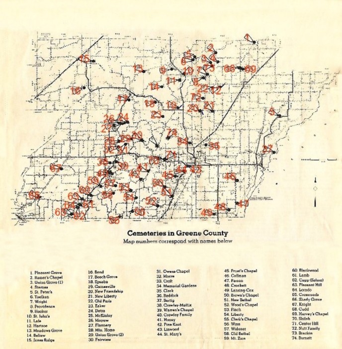
Starnes, took up where the RCI Clubs had left off. This map, prepared by Starnes, indicates the locations of 74 cemeteries, including all major ones and even some with just a single grave. It is obviously, as Starnes noted, "the result of many years of searching and interviewing." Starnes, the last president of the historical society when it was still active 10 years ago, now lives in Birmingham, Ala. During his presidency the society published a number of updated cemetery censuses in its quarterly. "Unfortunately, I left before the project was even half com-pleted. But it is my goal to eventually locate all of them, do updated censuses and publish them in a book," he said. While researching the cemeteries on the map, Starnes and others found or heard references to several other cemeteries or family plots that they have not yet been able to locate. That list included: Unity (perhaps two unmarked cem-eteries known by that name), Howell, McDaniel, Hargroves, Cupp, Tenneson, Sig Island, Oak Grove, Clemens, Macy, Blooming Grove, Bratton, Lovell, Fender, Straughn's Chapel (also known as Baker-Stevenson and later Marvin Thompson Farm), Nutt-Ray and a second Lamb cemetery. The researchers had also heard that there might be a cemetery of graves on the J. T. Williams farm, which may have been known as Johnson Hill; graves on the W. I. Holland farm near Campground; a cemetery or graves on the Ellis Walls farm; a grave or graves on the Bud Stevenson farm; and an unmarked cemetery near Delaplaine, which may have been known as the Green Cemetery. Starnes has asked that any readers who may have heard anything about these cemeteries or graves write him at 4939 Coshatt Drive, Birmingham, Ala., 35244. He is particularly interested in any history of the cemeteries as well as specific directions so they can be located and added to the county map. Starnes also suggested that readers submit names, cemetery of burial, dates of birth and death, if available, of persons known to have no burial markers.
|