We know from early descriptions, maps and text by outsiders like the early Spanish missionaries and French traders there were Indians in the Red River Valley and the Arkansas River Valley. Also, by recounted history by the Caddo Indians themselves. The Caddo language was oral, never a written language. Caddo songs recount their past history they still do the Turkey Dance, the first of a series of dancers. Men sit in a circle in the middle at the drums and sing and women dance around the men. There is still approximately 5000 Caddo Indian's scattered around the States mostly in Oklahoma around the Binger area [4,206 on the tribal roll in 2001]. They don't have a reservation, never had, but do have a face book page. They were formally recognized by the federal government in 1936 and the Caddo Nation is self-governing under a Constitution that provides for tribally elected officials. Administration offices, Culture Center, Heritage Museum, Head Start and Senior Citizen Activity buildings and a traditional dance ground are located within a complex on Caddo Trust land near the town of Binger, OK. Many pieces of pottery have over the later years been repatriated back to the Caddo Indian Nation.
Caddo Indians flourished in Arkansas from 1000 A.D. to 1800 A.D. By 1804 Caddo Indians had migrated south and relocated to Texas and Oklahoma. This was a tough period for all natives. Population levels dropped drastically. Native people were pushed out of the area and disease took its toll. Archeologists have studied material traces of the past activity like things left behind e.g. tools. They try and leave things in place and take a lot of photographs and try and answer questions. Where did they come from? How did they deal with climate change?
What evidence do you see of
trade and interactions?
These people were not isolated, they were connected as we know they traded.
Trading was an important part of the Caddo society and culture and had developed
extensive networks. It provided some security against attack and served as a
means of acculturation into the new European society. Trade was also a
major factor in the exploration/settlement for Europeans- Americans.
What did people do for food?
The Caddo Indians relied on the white-tailed deer for food, and the skins were
used for clothes and moccasins also they used the skins for bed coverings and
curtains for privacy. Tools for flaking stone into arrowheads were made from
deer antlers. Awls, needles and pins were shaped from deer bone. All but the
head and intestines were cooked.
When did they start to farm? When did we see increasing complexity in society? The answer come from archeological data e.g. artifacts and ecofacts. It is not just what is found, but where and with what. Recording location and association is key to interpretation. If pottery is found the chemical composition is looked at to work out if it was local or did it come from somewhere else.
Ouachita a member of a former North American Indian tribe, apparently of the Caddoan stock, of NE Louisiana. The name Ouachita comes from the name of a group, "Washita Indians," or town of Indians living along the Ouachita River near what is now the AR-LA state border in the early 1700s. Ouachita is the river flowing SE from west Arkansas through NE Louisiana to the Red River. 605 miles (975 km) long. According to the Encyclopedia of Oklahoma History and Culture, the name comes from the French transliteration of the Caddo word washita, meaning "good hunting grounds."
Why did the Caddo Indians settle in the area?
Maybe multi factorial: Water, waterways, shelter, timber for fuel and building, fishing, hunting, wild plants, weather, and novaculite.
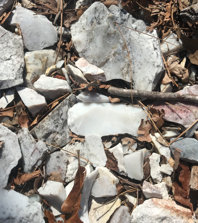
Novaculite
quarries have been used for thousands of years. The silica stone has
been used as
a sharp tool, it was an important resource. It was a mineral that was mined then traded
with lowland tribes.
Where they trading more or keeping more?
Novaculite,
derived from the Latin word novacula, meaning razor stone, is very resistant to
erosion and the beds stand out as ridges in the
Ouachita Mountains.
This rock is made up of very small quartz crystals, and is quite dense and hard. The Ouachita are the only ridges in the U.S. that run east and west. The
sedimentary origin rock is tightly compressed and sharply folded and listed here
in order of abundance: shale, snadstone, chert, novaculite, tuff, limestone and
coglomerate. Limited metamorphic hard rock include shale to slate and sandstone
to quartz. Novaculite is unique to the Ouachitas and is found along the upper
slopes of the mountains in a variety of colors. The colors range from white to
black, red, brown, green including blue-gray, peach and cream. It can be chipped
into arrowheads, spear points and was a valuable cutting tool. It is estimated
there is 300 to 500 miles of novaculite ridges in the Ouachitas.
Montgomery County. Specific quarries are located in
different counties in the Ouachita Mountains around the Hot Springs area.
See map.
Novaculite rocks can be seen on mountain ridges in western Arkansas
and eastern Oklahoma. Novaculite is hard with a high content of
microcrystalline quartz, white to grey or black in color. Arkansas
novaculite has two categories. 1. Arkansas Stone is extremely fine-grained with
a waxy luster. 2. Ouachita stone aka Washita stone has a dull luster, it is less
dense.
Geocache.
Research on Arkansas Novaculite – from quarries to tool production locales to the exchange of raw material or tools beyond the Ouachita Mountain sources – led to a new website, “Arkansas Novaculite: A Virtual Comparative Collection.”
Glossary
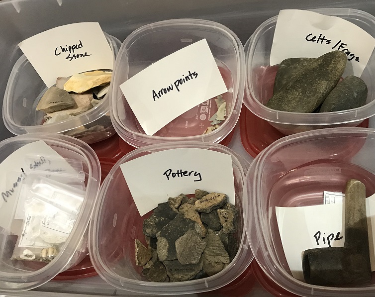
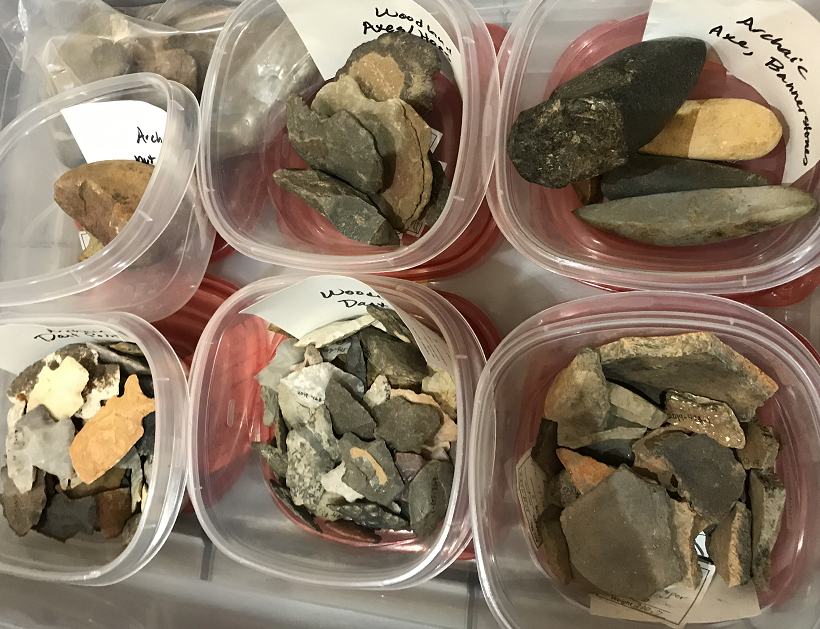
Arrowheads are classified according to the notch
type, including side, bottom, corner, and stem, blade form/shape, and size.
Birdpoint: a colloquial classification, small arrowhead .5inches long.
Collier mean length 3.11 to 4.46cm, relatively long, narrow points with side
notches and convex stems.
Keota mean length in the Ouachita basin 2.37cm. Relatively widespread in the
Ouachita Basin. [Early]
Womble points lengths range 2.22cm to 3.39cm, mean 3.17cm. Stemmed, corner
notched, slender triangular, straight non serrated blades, distinct unbarred
shoulders, expanding and convex lateral basal stems.
cobble: is a clast of rock
celt: a prehistoric stone or metal implement with a beveled cutting edge,
probably used as a tool or weapon.
clast: a constituent fragment of a clastic rock.
clastic: denoting rocks composed of broken pieces of older rocks.
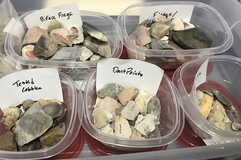
dart points: large unstemmed thin bifaces that were probably used as knives.
Dart points differ from spear points principally in the length of the
shaft upon which the pointed was hafted i.e. fixed to.
flake: a piece of hard stone chipped off for use as a tool
haft: the handle of a weapon or tool.
Knapped: chipped. Hard percussion is done to rough out the specimen. with soft
percussion following. This can be broken down into direct and indirect
percussion using an intermediate tool. Pressure flaking is used to put on
the finishing touches done by hand with an antler.
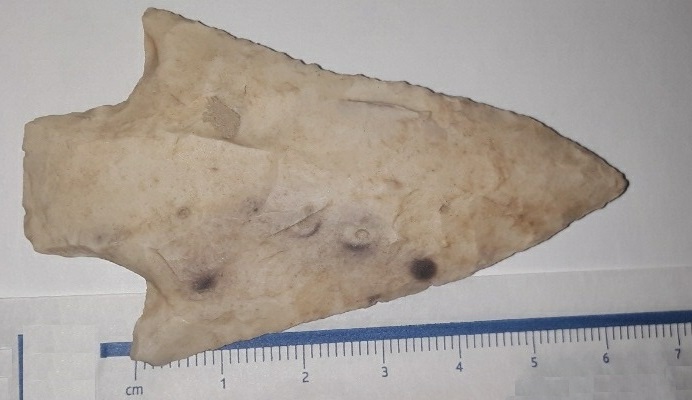
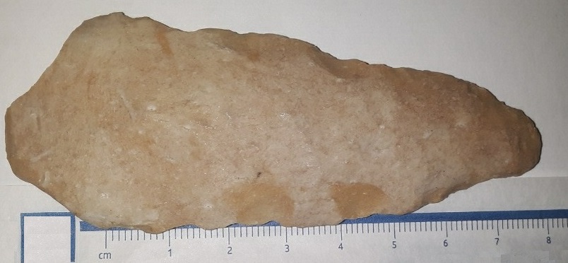
Yes, man-made! Both look like novaculite. They both look like dart points (hafted onto thrown darts rather than shot from bow and arrow), although the one may not be all the way finished. The one with the straight base looks like a Late Archaic style of point archeologists call Bulverde around here - a style found in this area on sites ca. 3000-1000 BC. The one with the u-shaped base looks thicker and may not be finished (or may have been used as a hafted knife rather than a hafted dart point) - it looks like the style we call Gary, and would be a little younger, maybe 1000-0 BC, Woodland period. Compare with some on website wrote Mary Beth D. Trubitt, Ph.D. 10 Feb. 2020. Found by TJ near Bonnerdale, Hot Springs County, January 2020.
Coleman, Roger E. Novaculite acquisition and
use at Little Missouri Falls: an early middle archaic site in Montgomery County,
Arkansas
The Arkansas Archeologist: Bulletin of the Arkansas Archeological Society
42:15-43 2001 (published in 2003) maps, tables, diagrams, graphs, bibl.
Subject Excavations (Archaeology), Indians of North America--Implements
Preservation of sites are protected and come under the legislation at State Level (Arkansas Historic Preservation Project) and Federal Level and COE if involving a waterway.
The WPA archeological projects 1930s -1940s.
There were four WPA sites in this area, two of
them are now under Lake Ouachita.
Poole site 3GA3, Wood 1981, is now
under Lake Ouachita
had a rectangular house, pottery chips and dart points made from local available
stone.
Adair site excavated by the WPA crews and is now under Lake Ouachita.
Dragover site on Ouachita National Forest property. Found fruits, grapes,
berries and persimmons and wild animals including deer, turkey, squirrel, bear,
fish and mussels.
Jones Mill site
in Hot Springs County. Lots of burned hickory nuts enable carbon dating to be
done. Middle Archaic period. Cooking techniques changed over the centuries. A
method of indirect cooking was using a pit with heated stones in the bottom,
food wrapped and dirt put on top. Pits often found in clusters, a cooking zone.
Anvil stones uses for processing nuts have been uncovered by archeologist in the
Lake Ouachita region.
Squash from Montgomery County, AR has been radiocarbon dated to AD 715-940, proving early farming in the Ouachita River Valley.
Adair, Garland County
It would have been like a service town with important structures for the
Dragover and other communities.
The Adair site was excavated
in 1939 by Samuel Claudius Dellinger and field assistants, was interesting as it included several mounds
including on 14ft high. Mounds are usually
mortuary or structural mound (burned buried buildings.) The WPA trenched through
a mound and found it to be a structural mound. When a building was
decommissioned it was burned and dirt thrown on top to smother the cinders and a
new building would be built on top of this. The cycle repeated over the decades,
so on structural mound might have 7 or 8 burned and buried structures. Also at
Adair there were wall posts from large circular houses and a cemetery.
Mounds in TX. Sam Dellinger: Raiders of
the Lost Arkansas by
Robert C. Mainfort, published Dec. 2008, Lavishly illustrated with over two
hundred images of artifacts, 144 pages.
Dellinger a professor at Hendrix College in Conway, Arkansas, had a passion for archaeology. His first excavations were along the Ouachita River in the 1920s. In 1929 Dellinger was able to persuade Harvey Couch, head of Arkansas Power and Light, to fund excavation of several important archaeological sites along the Ouachita River in Garland County that would be inundated upon completion of the Carpenter Dam. This work represents one of the earliest examples of “salvage archaeology” in the eastern United States. Dellinger gave some of the excavated pottery vessels to Couch and Couch’s friend Senator Caraway.
M.R. Harrington Indian Notes and Monographs online. 1920
Certain Caddo sites in Arkansas
Harrington explored five sites near Cedar Glades, 22 miles west of Hot Springs.
Site 1. Where?
Site 2. Judge O.H. Stumper owner of the next farm up the river from Golden's.
John Lillard was the tenant. The site was level land lying at the forks of the
two streams where Blakeley Creek joined the Ouachita about 18 miles west of Hot
Springs.
Site 3. Ritter place. Mr T.H. Ritter. Across the creek from the Stumper farm.
Site 4. Mr Cotten Golden
Site 5. Mr Samuel Robbins, Sr., of Cedar Glades, on east bank of Blakely creek,
a mile and a quarter above its junction with the Ouachita. On the hillside above
was a fine large spring. plate XLIX
Best to use all sources in combination.
Paleo-Indian Period
-12,000-10,000 BC. Humans first appeared in the archeological record in North
America. Had a distinctive style of tools made out of quartz crystal. In Arkansas
they were not hunting big animals.
Dalton culture - changes in climate, had to adapt.
Archaic period - the people were hunters, fishermen and gathers
so ate wild plants. Population was increasing. For fishing they made nets out of
organic material and used notched pebble weights (a simple tool), can be found
in clusters, like a necklace that was once tied to a fishing net so evidence of
gathering organic materials, making string: making a net is complicated.
Woodland period - 500 BC - AD 1100 - appearance of pottery, bow
& arrow, evidence of farming and settled villages, mound building. There was a
shift from oily nuts to oily seeded plants like sunflowers, marsh elder, squash
and to starch seeded plants like goosefoot (a relative of quinoa), knotweed and a little barley. Later
we get maize and corn which came from the SW. They were adding fat to their
diet. Already into the idea of farming, collecting and domestication. Arkansas
has been a farming state for 3000 years.
History of the Ouachita Mountains.
Novaculite, is hard, fine grained silica, similar to chert or flint.
Mary Beth D. Trubitt, Ph.D., Archeologist,
Arkansas Archeological Survey -
Henderson State University Research Station
Some of the information and photographs above gathered from a lecture 3rd Feb. 2020 at the COE
headquarters, Blakely Dam. Posted here with Mary Beth D. Trubitt, Ph.D.
permission. 5 June. 2020.
Annual report of the Geological Survey of Arkansas 1892
Caddo Gap is a deep gorge through which the Caddo River, in the western part of 4 S., 24 W., crosses one of the main novaculite ridges. Beyond, to the west, the ridge rises again to a height of 580 feet, and continues toward the head waters of the Little Missouri River.
In the ridge on the west side of the Caddo River, and immediately north of the village of Caddo Gap, a stain of iron occurs in the novaculite at the contact of that rock with the shale, on both sides of the ridge, and occasionally small masses of ore are seen. These exposures can be followed thence westward, but the quantity of the ore is insignificant and of no commercial importance.
"S Crossing" Such occurrences as those just mentioned at Caddo Gap, are again seen on a trail crossing the main ridge about two miles west-by-north from the village of Caddo Gap. The trail passes through a circuitous gorge, from which the name " S Crossing " has been derived. In places on the south slope of the mountain, on this trail, the novaculite is stained a deep rusty color, and contains thin seams and pockets of iron ore like that just described as occurring at Caddo Gap. These vary from one to eighteen inches in thickness and occur in a belt of novaculite about fifty feet wide. They are not in workable quantities.
North Mountain is the name locally applied to the novaculite ridge running north-of-west in 4 S., 26 W., about two miles north of Fancy Hill Post-office. It is the continuation of the ridge at Caddo Gap. On the slopes of the mountain the iron and manganese stratum occur in the gray- novaculite, near its contact with the shale, and follows the strike of the rocks along the ridge. Both the iron and the manganese ores are in very small quantities, the latter especially so, and the ore-bearing stratum is usually marked only by a ferruginous stain or by small seams or bunches of iron ore.
A similar ore occurs in a hollow separating this hill from the mountain to the north, and in one place a bed ten feet thick was seen. In many other places in the neighborhood, both to the east and to the west, in the direction of the strike of the rock, similar though somewhat smaller outcrops occur. The ore intermittently blends into the shale and disappears.
Caddo Mountain bears east and west through the extreme southwestern part of 3 S., 26 W., and into 3 S., 27 W. It runs parallel to and on the immediate south side of the Caddo River, rising about 400 feet above it. The crest and the upper parts of the ridge are composed of gray novaculite, and the black siliceous shale occurs on the slopes. On the summit are numerous outcrops of a black or dark gray iron ore, with a bright submetallic lustre, frequently in globular, stalactitic, or mamillary forms. It is in thin seams- and pockets, from a fraction of an inch to a foot in thickness, and generally forms the cement of a breccia of novaculite fragments. It decomposes on the surface into a brown, earthy-ore. The mixture of ore and rock is from ten to forty feet in width. It was followed for two miles along the crest of the ridge and is doubtless traceable for a still greater distance. The amount of ore, however, in any one place is small, as the novaculite fragments compose by far the larger part of the ore- bearing stratum. The ore, though sometimes in small pockets free from rock, is generally in the form of thin layers or films in the novaculite.
Centennial History of Arkansas By Dallas Tabor Herndon pg31 (1922)
In Arkansas the only recognized Cambrian exposure occurs in Montgomery County, in a valley between the headwaters of the Ouachita and Little Missouri rivers. This valley is from one to three miles wide and about fifteen miles long. The formation (known as Collier shale) is composed chiefly of a dark shale and a bluish-gray or dark limestone, interspersed with layers of chert. None of the limestone is adapted for building purposes, and very little of it is suitable for the manufacture of lime, on account of the impurities it contains. The shale beds are believed to be five hundred feet or more in thickness. Other geologists assert that the lower part of the novaculite formation belongs to the Devonian period. The novaculite (whetstone) area occurs in the hilly regions south of the Arkansas River, especially in the Zigzag Mountains about Hot Springs, in the Ouachita Mountain system south of the Ouachita River, and extends from the eastern part of Hot Spring County almost to the Oklahoma line. Concerning the finest quality of this novaculite, commercially known as Ouachita oilstone, Owen says: "
Next in geologic age is the Lower Silurian, or Ordovician the oldest certainly recognized sedimentary rocks in Arkansas. They consist of magnesium and siliceous limestones, sandstones and cherts. A geological map of Arkansas published by the United States Geological Survey in 1907, shows two well defined Lower Silurian areas. The first, in the northern part of the state, the second area, south of the Arkansas River, includes the larger part of Garland, Saline and Montgomery counties, the southwestern part of Pulaski. a triangle in the eastern part of Polk, a small section of the northern part of Pike, and a belt across the northern part of Hot Spring County.
page 34. The Stanley shale occurs in Clark, Garland, Hot Spring, Howard, Montgomery, Pike, Polk and Sevier counties. In Pike County it is about six thousand feet thick. Quartz veins in this formation in Sevier County contain antimony, lead and zinc, but the deposits have never been fully developed.
page 474. About 1839 Ira B. Whitmore, of Little Rock, became associated with Tapley H. Stewart, who had been interested in the mines amount Dahlonega, Georgia, and the two men visited one of the old Spanish diggings in Montgomery County. They brought back to Little Rock a few specimens of gold ore, but it does not appear that they made any effort to develop the mines in that locality.
page 475. Dr. John C. Branner's report for 1888 may have been responsible for some of the activity that followed immediately afterward. In that report he says: "There is a very enticing field for prospectors northeast of the Bellah and Davis mines, as far as Silver City (in Montgomery County), along a narrow belt and in a southwestward continuation of the same belt indefinitely into Oklahoma. In his report for 1920 the commissioner of mines, manufactures and agriculture mentions but one concern engaged in silver mining. That was the Silver King Mining Company, a Hot Springs corporation, which was organized for the purpose of developing the Waterloo mine, near old Silver City, Montgomery County. In June, 1921, this company published a report stating that ore from the lower levels of the mine had been sent to St. Louis for examination and assayed $380 of pure silver per ton. If this report be true, silver mining in Arkansas may become a reality.
At Balanced Rock, Hot Springs, off Cedar Glades Rd, March 2021.Annual report of the Geological Survey of Arkansas 1892
The Bud Jones claim No. 2. The Bud Jones claim No. 2 is in 3 S., 23 W, section 23, the southwest quarter. It is less- than a mile south-by-east from the last locality. Fragments- of iron ore, similar to the first kind described at the last place, are scattered over the surface. The ore is not seen in place, as the main deposit is concealed by loose material. The surface fragments are frequently made up of a mass of thin stalactite branches, from a sixteenth to a quarter of an inch in'
diameter.
The Bud Jones claim No. j.
The Bud Jones claim No. 3 is in 3 S., 23 W., section 29, the north half. This claim is on the north side of a novaculite ridge and half way up its slope. The gray novaculite forms the summit and upper part of the ridge; the siliceous shale forms the lower slope. The rocks all strike east-west and dip steeply to the north. A seam, two and a- half feet in thickness, of a porous brown iron ore, occurs in the gray novaculite, and is often coated with a brilliant red ochre. Unlike most of such exposures, however, this deposit of ore is not interbedded with the rock, but dips at about 70 east, and strikes north and south directly across the stratification. On the slope of the ridge, the gray novaculite forms an almost vertical ledge for ten or fifteen feet above its contact with the siliceous shale, and then slopes upward more gradually. In the face of this ledge a cross section- of the ore deposit is well exposed. Twenty feet above the shale the deposit thins out to a few inches in width. Sections- of similar though smaller deposits, from one to twelve inches in thickness, are seen in the face of the ledge. Sometimes- thin layers or small pockets of the same kind of ore follow the contact of the two rocks in the normal interbedded manner. The deposits across the bedding probably represent crevices filled with ore derived from the bedded deposits or from iron scattered through the surrounding rocks. The ore is in too-small quantities to be of value as a source of iron.
Analysis of iron ore from the Bud Jones claim No. j, Montgomery County.
Iron 54.54
Silica 0.84
Phosphorus 1.79
Manganese 0.30
The analysis shows the ore to be of good quality in its high percentage of iron and low percentage of silica, but its value is injured by its large percentage of phosphorus. The Dunney claim. The Dunney claim is in 3 S., 23 W., section 30, the northeast quarter of the northeast quarter. It is about a half a mile west of the last claim and on the summit of the same gray novaculite ridge. The ore deposit consists of a breccia of soft, angular, novaculite fragments, from a fraction of an inch to six inches in diameter, cemented by a bright, submetallic, steel-gray iron ore. The ore is generally in the form of thin seams, a fraction of an inch in thickness, cementing the rock fragments, though sometimes pure masses several inches in diameter are seen. Occasionally it is in mammillary or stalactitic forms, or in small, flat nodules stuck to the novaculite fragments. The breccia runs along the ridge, but rapidly thins out in either direction. This ore is too much mixed with the rock to be of value, and the quantity is too small to pay to concentrate it. An examination of the breccia shows that, though the fragments of the rock are separated by thin layers of ore, the angles of any two pieces of rock directly opposite each other would almost always fit together if the ore were removed. It is probable, therefore, that the brecciation is caused by the shattering of the rock in place, and not by the cementing together of novaculite fragments indiscriminately mixed. The Golden Gate claim. The Golden Gate claim is in 3 S., 23 W., section 31, the northwest quarter. Here the same breccia is seen as at the last place, except that the iron ore has a brown, dull, earthy, porous appearance, instead of a bright submetallic lustre; a fact, however, which may be due to surface weathering. The thickness of the outcrop is not seen on account of the covering of loose material, but fragments of ore are scattered for a distance of over two hundred yards along the north slope of the mountain. Occasionally masses of pure ore are found, weighing from one to two hundred pounds. Township 4. S., 24. W. The main novaculite ridge of this region passes through township 4 S., 24 W., from northeast to southwest, in a series of zigzag folds. Small quantities of iron and manganese ores are found in the novaculite at many places in the hills, but both are in quantities of no importance whatever and do not require further mention. Minerals in AR by county. Quartz
Archeology dig in Montgomery County, AR
Caddo Hills Ceramics.
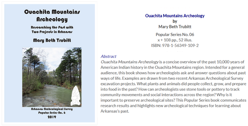
Ouachita Mountains Archeology by Mary Beth Trubitt 108pp, 52 illus.
A concise overview of the past 10,000 years of American Indian history in the
Ouachita Mountains region.
Rock hounding in Arkansas
Collecting rocks - always record where the rock was found.
Self
Guided Float Trip of Lake Ouachita 16 miles.
Rockhounding
Minerals in ONF
The Caddo Indian Burial Ground, Norman, Arkansas &
Caddo Indian Memorial Trail, Norman
Early, Ann M. with Burnett and Wolfman, Standridge: Caddoan Settlement in a Mountain Environment, Arkansas Archeological Survey Research Series No.29, 1988. Both circular and rectangular houses and special purpose structures have been found at other Mississippian Caddo sites in Montgomery County. One of these was the Standridge site about five miles down the Caddo River from Norman. Yellow pine was used for framing Caddoan wooden structures. White oak and hickory were also found at the site. A total of 97 small arrow points was documented from the Standridge site. Ear ornaments
The early Caddo Indians hunted wild game, cultivated vegetables and gathered nuts and berries. They lived near water and forests. They also developed ceramics for storage of seeds. Trees and shrubs were relied on for food and shelter. Black walnut, peach, pecan, persimmon (sweet after frost) and wild plum. The Smooth Sumac was used for tea. Shrubs include Possum-Haw, Elderberry, Indian Currant, Witch Hazel, Prickly Ash ("Tooth-Ache" tree), Leatherwood useful for weaving/basket making and Silverbell which feeds small mammals, birds, deer and bear. Bois D'Arc the straight grained pieces were used for bowls. Hackberry, Willow, Black Cherry, Mulberry, Redbud, Pawpaw and American Holly, Flowering Dogwood, Black Gum (often has cavities for wildlife) all still serving a variety of purposes. The vines commonly found include Grapes (Muscadine, Pepper Vine, Possum), Honeysuckle, Creeping Cumber, Morning Glory, Poison Ivy, Woodvine... Wildflowers in the Caddo River area include Corn Gromwell, Beggar's Lice (both seeds were found in archeological sites), Lettermans Ironweed, Poke Weed, Gold Seal, Buttercup, Bloodroot (can be used for the dye), Wild Strawberry, St. John's Wort, Wood Violet, Queen Ann's Lace, Button Weed (turkey food), Goldenrod, Dandelion...
The Caddo pottery was made by rolling out prepared and kneaded clay into long strips, which were coiled round and round, each coil until the form had been built up, and being blended with the preceding, by aid of fingers and a wet smoothing stone. Pottery was woman's work.
Today in 2020
People are finding Caddo artifacts daily, yes, there is still plenty to discover. Up the Ouachita River around Sims, farmers and their family members know where to look. During agriculture work stone artifacts still get uncovered and after floods. Going for an evening walk they keep their eyes open. Many of the local children have a collection and some families have buckets full of arrowheads. They keep the arrowheads in a bucket and just keep on adding to it. Around Pencil Bluff usually in a bend in the river and on the land in the vicinity stone artifacts are discovered. In the south part of the county especially along creeks and neighboring counties, families have good collections. The local museum does not have a collection on display and declines to accept pottery as they know it is probably excavated from Indian mounds years ago. Excavation of artifacts from federal lands without a permit (and that includes State Parks) is a violation of the Archaeological Resources Protection Act of 1979. All artifacts excavated from federal lands are the property of the United States, according to the act.
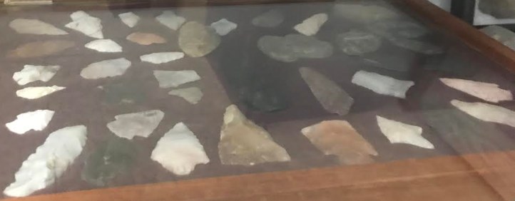
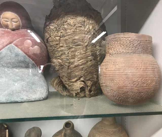
Burl's Smokehouse in Crystal Springs, AR. I stopped there
and had a look around in Feb. 2020. There is a room dedicated to Indian artifacts - Caddo,
Quapaw as well as Mississippian collected in the 1930-40. Three collectors, one
being a Dr Meeks, would trade artifacts between each other. There is Caddo pottery and also some pieces
from further east in Arkansas as well as some pieces from the American Southwest
and other areas too. Remember a vessel that is complete, with minimal evidence
of repair, strongly indicates that it was found in a Caddo grave, where it had
been placed as a funerary object. The term "funerary object" means an object
that, as part of a death rite or ceremony of a culture, is intentionally placed
with individual human remains, either at the time of burial or later.
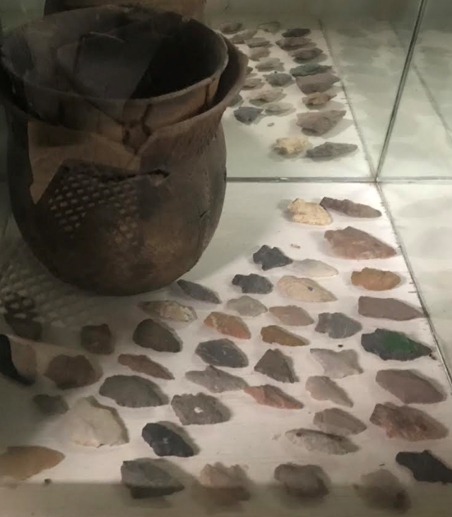
At Burls.
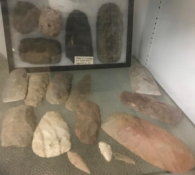
At Burls. In frame 2 scrappers & 3 spade blades from Crawford Co. AR.
I also understand Wright's Grocery Store in Glenwood has a display on a back
wall of Caddo Indian artifacts.
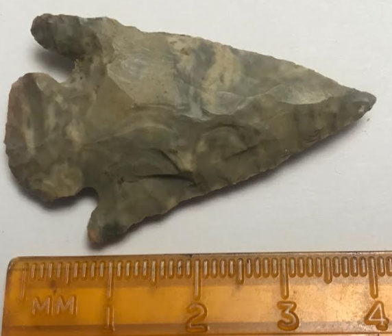
Is this arrowhead old or a modern arrowhead? Said it was found in Murfreesboro, AR.
At living history events in Arkansas you can often see someone flint knapping.
Knapping is the shaping of flint, chert or other fracturing stone to manufacture
stone tools. The original Germanic term knopp meant to strike, shape, or work.
Modern usage is more specific, referring almost exclusively to the hand-tool
pressure-flaking process. Remember no piece of Novaculite is exactly the same as
another – even of the same grade. Translucent to gray are considered common
colors. All other colors are uncommon.
At Burl's.
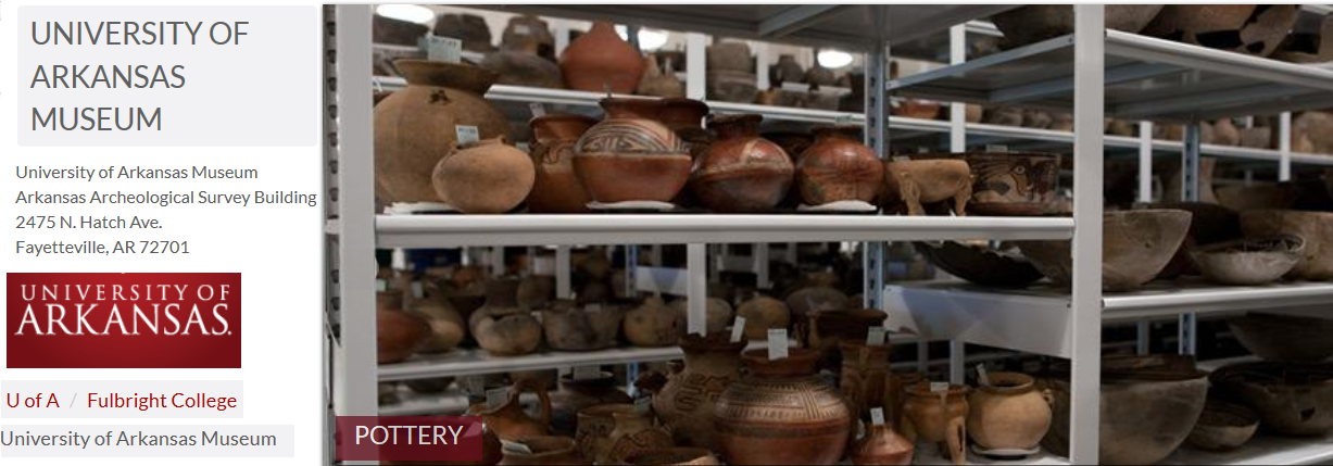
University of Arkansas Museum Collections
The collections housed at the University of Arkansas Collections Facility, located at the University of Arkansas Agricultural Experiment Station in Fayetteville are Arkansas' the largest and most significant collection of archeological material anywhere with more than 7,000 catalogued Native American whole pottery vessels. These vessels represent late Mississippian Period cultures of the Mississippi and Arkansas River Valleys and Caddoan culture of the Red and Ouachita River regions. Collection Tours are free just need an appointment, email lalamb@uark.edu or call 479-575-3456 to schedule your tour!
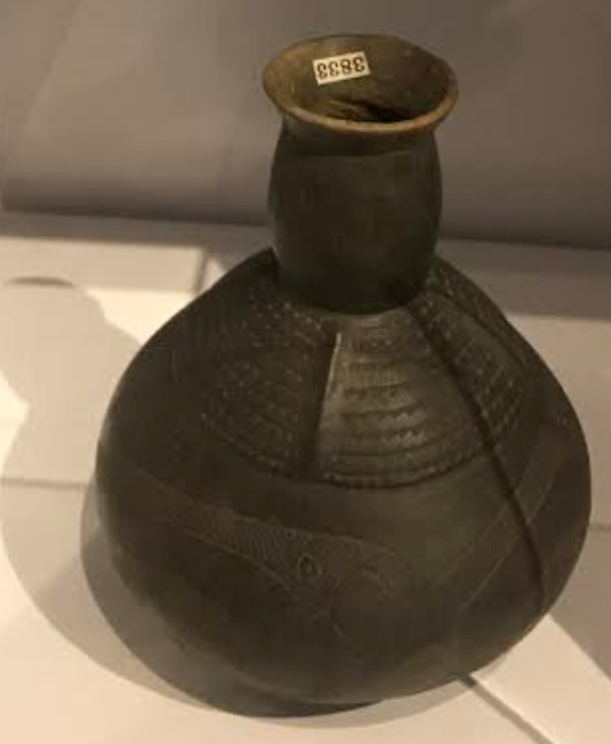
CLAY
This Caddo vessel from southwest Arkansas was likely made of local clay and fired in an open hearth. Such clay is found throughout western Arkansas. Caddo potters started using it around 1000 A.D., and today Arkansas is one of the top clay-producing states in the United States. Caddo vessel on display June 2020 at the Mid America Museum, Hot Springs, AR. The vessel is on loan from the University of Arkansas Museum Collection.