Blakely Mountain Dam, Arkansas
History Civil Works Project Info May Maps
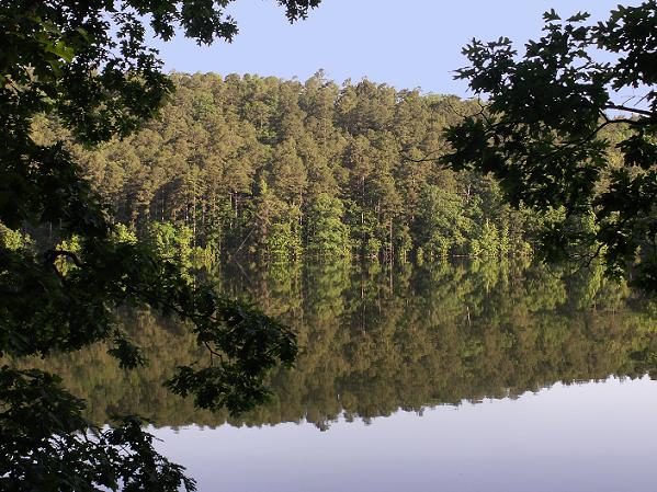
Beautiful Lake Ouachita, a recreational haven, is located in Garland and Montgomery Counties, Arkansas, 13 miles west of Hot Springs. The lake was formed when the flow of the Ouachita River [pronounced Wash-i-taw] was dammed by the COE in July 1952 with the closing of the gates. Jim Stephens was the resident engineer said he was unable to estimate the time it will take for the lake to form, saying that it depended largely on the amount of rainfall. Six hundred graves were relocated and communities and farm land lost. Old Buckville, Cedar Glades (Harold), Flea Bend (Aultville), Oakwood (Chalybeate Spring), White Plains area are under the waters of Lake Ouachita. It is one of the cleanest lakes in the nation. Provides a variety recreational opportunities for fishing, scuba diving, skiing, sailing, boating but also provides hydroelectric power and flood control. Camping and hiking trails abound in the Ouachita National Forest. Trophy striped bass and largemouth bass are common pursuits at Ouachita, but this is also one of the state's top producers of bream, heavyweight catfish, white and spotted bass, crappie, and walleyes.
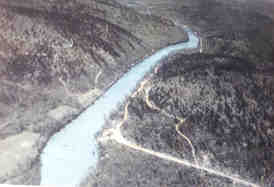
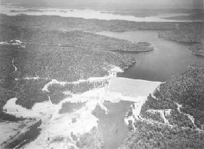
Aerial view of the Blakely Mountain Dam site prior and soon
after construction. map
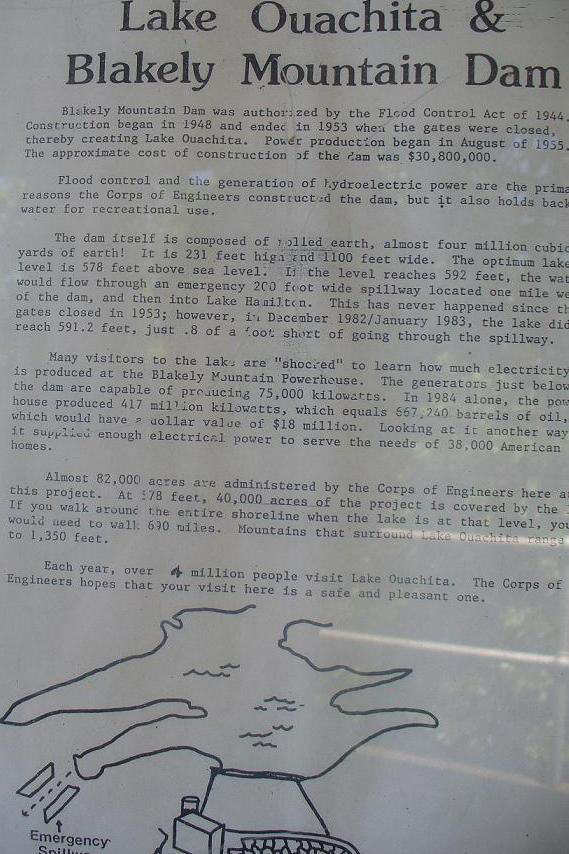
The Blakely Mountain Dam was authorised by the Flood Control Act of 1944. Construction began in 1948 and ended in July 1952 when the gates where closed, there by creating Lake Ouachita. Power production began in August of 1955. The power station is open to visitors Monday - Friday between 9 am and 4 pm. You can view photographs from the construction period, the control room and the two turbines. The generators are capable of producing 75,000 kilowatts. In 1984 produced 417 million kilowatts. Constructed and operated by the Corps of Engineers, US Army, Vicksburg District, Vicksburg Miss. Blakely Mountain Dam, was dedicated July 3-4, 1956.
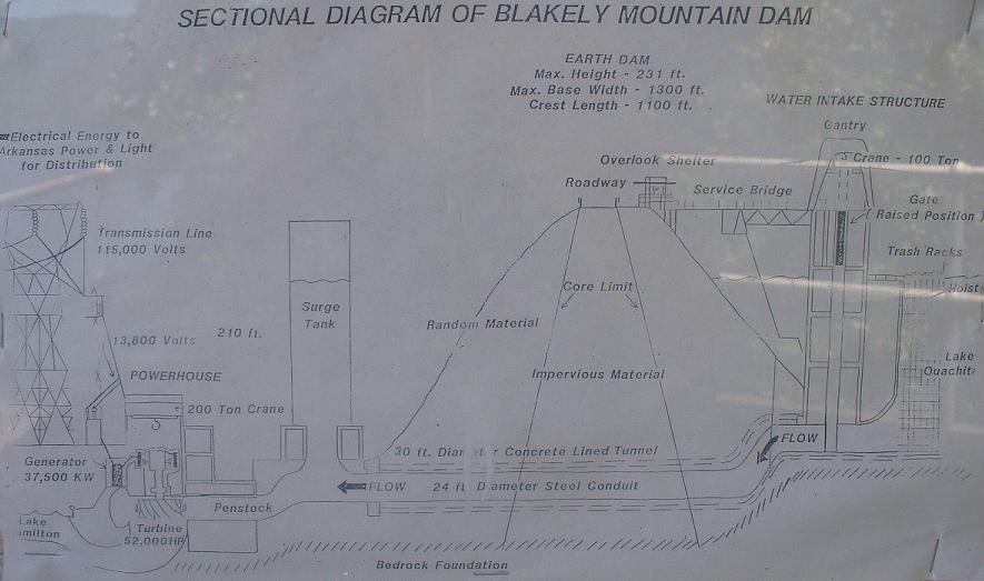
The dam itself is composed of rolled earth, almost four million cubic yards of earth, a $32,600,00 project. It is 231 feet high and 1100 feet wide. The optimum lake level is 578' above sea level. If the level reaches 592' the water would flow through an emergency 200 feet wide spillway located one mile west of the dam and then into Lake Hamilton. This has never happened since the gates where closed in 1953 however in December 1982 - January 1983, the lake did reach 591.2 feet, just .8 of a foot short of going through the spillway.
The COE area covers 82,000 acres. At 578 feet, 40,100 acres of the project is covered by the lake. 690 miles around the shoreline. At 592 ft above sea level it would be 975 miles around the shoreline and the flood control pool would be 48,300 acres. Drainage area is 1105 sq. miles. Total storage capacity 2,768,000 acre feet. (One acre foot equals one acre of water one foot deep). The hills that surround the lake range up to 1,350'. At the top of the dam you can drive across and watch the sunset. From the COE info posted at the dam.
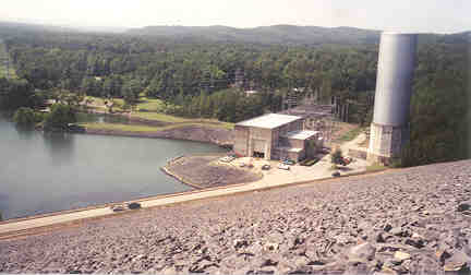
Blakely Mountain Dam
Avery Park is on the right. Stephens Park on the left. July 2001.
Riprap - is placing rocks or material for erosion control. The size of the
rock needed on a project depends on the steepness of the slope and how fast
water is moving. Riprap is a very durable, natural-looking treatment.
Note the seepage area has now been reclaimed - the clay.
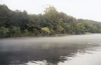
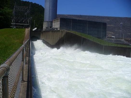
May 19 2009 - the lake was high so water was being released.
Below Blakely Mountain Dam on the Ouachita River / Lake Hamilton is the COE Stephens Park Campground. Visitors can enjoy trout and striper fishing but we didn't have any luck as the water was too cold. Water had been released that afternoon to build up the water level in the river/lake below the dam and the meeting of cold water and warm air caused fog. It was cool and beautiful to watch the thick fog roll in. There was also a water moccasin along the little path at the water edge near the power house and a mallard duck with six ducklings. It had been hot and dry up there in Garland and Montgomery Co. AR and all the creeks in the counties were low in July 2001. Bald Eagles are an attraction for the visitors during the winter. Avery day use park has a public boat ramp. Closest place to pick up picnic supplies would be Mountain Pine. Further north is Lake Ouachita State Park. Blakely Dam Road to Owl Creek Rd is a short cut to 270W west and on to Mt Ida. On the way stop at Charlton, a ONF Park. Fishing: white bass, strippers (sea bass), small mouth bass, rock bass, crappie, perch, walleye, catfish and others.
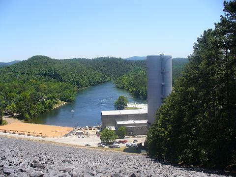
Below Blakely Mountain Dam
Stephens Park on the left. The water runs into Lake Hamilton. July 2001
"Mist" is generally applied to vapours
condensed on marshes, rivers, and lakes; "fog," to vapours condensed on
land.
If the surface of the earth is in a hollow then the air the vapour of the earth
is, chilled by the cold rain and becomes fog.
A wind touching on north will be too warm for a fog, and warm air converts
fog into clouds, or clouds into invisible vapour.
Lake Ouachita by Leslee Jaquette 1 May
1998
Trailer Boats 92 Vol. 27, No. 5
The largest body of water in Arkansas, this lake with the strange sounding
name beckons trailerboaters to play and fish, but most of all, soak up the
solitude and relax. This view from 1000-foot-high Vista Point on Hickory Nut
Mountain, shows how wild and undeveloped Arkansas' largest lake and
surrounding forest remain. The Frasier family of Malvern, Arkansas launches
their 17-foot Alumaweld before breakfast to take advantage of the best
conditions for waterskiing. This view from 1000-foot-high Vista Point on
Hickory Nut Mountain, shows how wild and undeveloped Arkansas' largest lake
and surrounding forest remain. Horseshoe-shaped and covered by a canopy of
oaks and maples, Sunset Point on Lake Ouachita (pronounced Wash-e-taw) looks
just as pretty over morning coffee as it does with cocoa at sundown. After
eggs and bacon on the aft deck of our 65-foot DreamChaser houseboat, my
teen-age nieces floated off a few calories. Gossiping and giggling, they
bobbed about in PFD's in the 89-degree Fahrenheit water of this Arkansas
lake. Dishes done, we fired up a 1997 Larson 20 1/2-foot, armed with a 5.7L
MerCruiser for an hour's skirmish through the watery "S" curve locals call
Skier's Cove. As the summer temperature cracked 100, we exchanged the rental
ski boat for a wave runner and carved lazy loops around Hotdog and Hamburger
islands. That evening after steak on the grill, the girls begged me to take
them bass fishing early, before the Midwest sun fried us whole. I said,
"Twist my arm." There's no choice but to surrender to the relaxed pace
presented by Lake Ouachita, Arkansas' largest lake. Rated as one of the
country's cleanest lakes and completely surrounded by wilderness, this U.S.
Army Corps of Engineers-created lake invites folks to slip out of their
shoes into a peaceful, unpolluted playground. With nearly 800 miles of
shoreline, hundreds of islands and coves, great fishing in combination with
down-home hospitality and first-rate marinas and camping, Lake Ouachita
offers trailerboaters enormous and underutilized recreational opportunities.
THE LAKE
After driving seven hours south on Highway 7 from my hometown of
Springfield, Missouri, I was overwhelmed by this lake's size and feeling of
isolation. Although Hot Springs, an historic vacation mecca known for its
bathhouses, hotels and horse races, sits a mere 13 miles east of Ouachita, I
felt far removed from civilization. The lake spreads 30 miles across like a
flat octopus with four sturdy arms reaching west and four puny arms reaching
east. The most southeasterly arm dead-ends at the Blakely Mt. Dam and
powerhouse built in the late 1940s. The lake was flooded nearly a decade
later. The only building directly on the lake is a relocated church, rescued
before the town of Buckville was submerged. The remainder of the shoreline
is protected as part of the Ouachita Mountain National Forest and is
uninhabited except for seven marinas. Lake Ouachita offers boaters a
playground with hundreds of islands and coves, first-rate marinas and water
so clean that some boaters drink it straight from the lake. We arrived the
middle of the week in mid-July, checking in with our host, Bill Barnes
owner/operator of the largest marina, Mountain Harbor Resort on Lake
Ouachita. He took me out to sample the eastern third of the lake. Boarding a
Cobalt 20, we cruised a lake that was nearly deserted. Bill explained that
while the Lake of The Ozarks in central Missouri claims nearly half a
million registered boats, Lake Ouachita only documents 4000. Summer weekends
may attract 500 to 700 boats with as few as 200 mid-week. And even though
the lake is centrally located near major highways, not many snowbirds
capitalize on the area's moderate winters.
MOUNTAIN HARBOR MARINA
Located about 23 miles east of Hot Springs, Mountain Harbor Marina caters to
all sorts of boaters, fishermen and day-trippers. With the recent addition
of the largest docks in Arkansas to accommodate a fleet of 90-foot
houseboats, the resort offers 27 separate docks with storage for 930 boats
(100 are sail). Bill plans to expand the family business eventually, which
was started by his father 47 years ago, to house 1400 boats. Other plans
include increasing the marine store from 1200 square feet to 4000 and
expanding the marine repair facility to accommodate a broader spectrum of
vessels. After our big night on the houseboat, we stayed at one of Mountain
Harbor's palatial condo apartments. For dinner we sampled the Lodge
Restaurant's Midwest-friendly service, indulging in the deep-fried onion
appetizer and catfish fingers. "We're a family place," says Bill. "We don't
sell alcohol and we don't want it loud. We think the world needs comfortable
and casual."
CRUISE, FISH, DIVE THE LAKE
At sunrise the next morning I caught up with Marina Manager Dick Antoine.
The temperature had already edged over 80 and steam smokes off the lake.
Manager for six years and host of the regional radio talk show, Talk of the
Town," Dick captivated me with his local knowledge and velvety baritone
voice. As we departed the marina he informed me that the Environmental
Protection Agency recently named Lake Ouachita the cleanest in the country.
What is more, Mountain Harbor is one of the ten largest inland marinas in
the states. With his ancient, yellow Labrador, Wendy Marina, anchoring the
bow, Dick told me that the Ouachitas are the only mountain range in the
Continental United States that runs east and west. This phenomenon tends to
provide protected waters except in spring. Buzzing past the arch of Skiers
Cove, we encountered several men fishing from a HydroSport 17. They were
pursuing black bass in preparation for the upcoming Poor Boys Bass Club
Tournament. "We're fishing between 20 and 30 feet using a Carolina rig. Go
to any point and fish off the moss beds," said angler Joey Fisher of Casa,
Arkansas. Carefully backing away, Dick told me, that of 30 participants in
the lake's Bass Master Classic, 13 are local fishermen. In fact, Mountain
Harbor Guide Gerry Bean probably claims more pounds than anyone around. And
according to a newspaper article mounted on the wall at the lodge Bean
admitted that he uses large shad suspended by a balloon. learned that, not
only is the lake full of largemouth bass weighing up to 15 pounds, it is
chockfull of Kentucky spotted bass, trout, walleye, bream, crappie and huge
trophy stripers in the 30- to 50pound range.
Local marinas rent houseboats up to 80 feet in length,
providing boaters with a moveable condo. Fishing nearby from his 20-foot
Champion bassboat powered by a 200hp Merc outboard, Robert Brown from
Dallas, Texas, detailed his motivation. "I come up here for a week's
vacation to get away from the steel and the glass," says Brown, who uses
live shad for bass. "Besides, I love this clear water and the fishing is
real good." Indeed, fishing is such a big deal that the resort publishes a
daily fishing report prepared by Dick and guide Hugh Albright. One report
noted, for example, that the largemouth are taking Texas- rigged 6- to
8-inch plastic worms, preferably crab-apple or June-bug colors. I also
learned that to optimize my chances I must return when the lake cools down
to around 70 degrees, either in the spring or in October. A little further
up the bend we glimpsed the family nature of Lake Ouachita. Craig Fraiser, a
school principal from Malvern, Arkansas, and his wife, Kay, and 12-year-old
daughter, Meredith, were out early to ski and swim before the heat
handcuffed activity. The family tows a raft behind their 17-foot Alumaweld,
powered by an 88hp Johnson. Craig waxed eloquent while his women fed a
family of mallards. "You've got to appreciate this lake; it's big, pretty
and fun to explore. Besides, Meredith would rather come here than be dragged
on a whirlwind tour of the country," he said.
EXPLORING THE DEPTHS
While most folks explore the lake's surface, it seems that a contingency of
about 80 scuba divers explore underwater for artifacts and fish. Gray Miles,
manager of R-Man Ski & Scuba Shop located at Mountain Harbor, said
visibility is good and divers are allowed to spearfish one-half the legal
fishing limit of bass, crappie, sunfish, walleye and catfish. Miles showed
me a photo of a diver clutching a 20-pound catfish. Divers tend to stay in
the top 30 feet of the thermocline, hunting around sunken brush piles that
are considered, "closely guarded secrets." While fishermen fear the divers
will decimate the lake, Miles says that's not a problem, "Divers are very
selective." Next door to R-Man, Tiny Borland of Tiny's offers visitors a
menu of rental PWC's, parasail adventures, houseboats and movie videos for
the off, rainy day. The first parasail operation in the state, that pleasure
costs $45 a sail. Continuing our tour, Dick pointed out 1000-foot high Vista
Point on Hickory Nut Mountain. He told how the lake elevation of 578 feet
can vary as much as 25 feet in the spring and how visitors can camp free for
up to two weeks on any of the lake's 200 islands. An enforced, no-discharge
waterway, Lake Ouachita boasts the only marine pump-out boat in Arkansas.
Reflecting on the character of the lake, Dick described one client, a
"zillionaire," who comes out on the lake in bib overalls to fish. Even this
man and his family need a place to relax. "See, our society beats us up, and
this is the best way to be captive with the family," philosophized Dick
Antoine. "Besides, everyone's got a little pirate in them and that pirate
wants to get out and play." Lake Ouachita is the place to do just that.
Navigating Lake Ouachita - Tipns by Mountain Harbor marina staff Dick
Antoine and Cort Bosley.
First thing, go to the marina office for topographical maps and a fish
report. While most of the 200 islands are buoyed, you'll need to watch
carefully for these drowned mountains. If you're serious about fishing, hire
a guide the first day. Summer heatbursts bring storms - be wary when it
comes to the weather. Don't boat at night. Ramming an island causes big
trouble. In October, take a naturalist trip to best view the lake's 80 to
120 bald eagles. This is a no discharge lake. Utilize the marine pump-out
boat. You are safe in the main channels. They are 120 to 180 feet deep.
Look out for moss around points. It can foul a prop or clog a water intake.
Play hard early to beat the heat in the summer.
Ouachita Dams - Arkansas Gazette
Magazine p.3 Nov 3, 1936
Dams--Blakely Mountain , Flood Control
Rounding up the dams
Abstract plans for building federal dams, and information on Blue Mountain,
Narrows, Norfolk, Bull Shoals, Blakely Mountain, Table Rock
Publication Arkansas Democrat p.5 Feb 10, 1957
Blakely Dam, a man-made mountain - Arkansas Gazette p.1F Jan 28, 1951
Ouachita River @ Blakely Mountain Dam, AR -
Pool Level Longitude:
93 41'51" Latitude: 34 36'36"
06/03/2013 586.99 Ft. 11.2" rain at Oden May 31 -
June 2 2013
05/19/2009
587.27 Ft. photo
05/16/2009 588.10 Ft.
06/03/2009 582.89 Ft.
06/19/2009 577.77 Ft.
01/27/2009 572.15 Ft.
1929 0 Ft.
Full Pool Stage: 578.00 Ft.
The optimum lake level is 578ft. above sea level.
Flood Pool: 592.00 Ft.
Spillway crest elevation 592 Ft.
Record High Stage: 590.1 Ft. Record High Stage Date: 12/05/1982
The water level rose 13.5 feet between December 2, 1982 and December 5,
1982.
Record Low Stage: 535.86 Ft. Date: 01/09/1954 . In July 1952 the
gates were closed and the lake started filling.
Level Controlled by: U.S. Army Corps of Engineers
Water level 567.72 Feet MSL Tuesday, October 26, 2021 & 7 Sunday 7 Nov. 2021. Level is 10.28 ft
below full pool of 578ft.
March 2009: Mt Ida precipitation 6.38 in.
April 2009: Mt Ida precipitation 5.25 in.
May 2009: Mt Ida precipitation 11.64 in
The annual average precipitation at Mt. Ida is 57.95 inches. Rainfall in
is fairly evenly distributed throughout the year. The wettest month of
the year is May with an average rainfall of 6.24 inches.