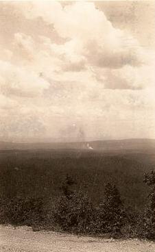
"No Man's Land Fire" .. its remote location seven miles west of
Black Springs in Montgomery County.
A wildfire has spread through a section of the Ouachita National
Forest in western Arkansas. Officials said today the fire had spread
over more than eight-thousand acres. Note
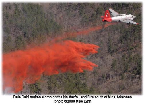
the spelling mistake in the photo caption - Mina should read Mena.
Montgomery County News, Thursday March 23 2006, page 1
It took five days, local fire crews and out of state fire crews, an
inter-tribal crew composed 20 Iowa and Cherokee Native Americans from
Oklahoma and 20 Northwest Regulars from Washington State, a Type 2,
Initial Attack group, and three days of rain to finally stop the
spreading "No Man's Land Fire" in southwest Montgomery County, Arkansas.
8,123 acres was burned.
Four fires were first reported to the local ranger stations on Monday,
March 13 after a storm Sunday night. Three were quickly put out.
The one fire that started on Bear Den Mountain about seven miles west of
Black Springs on Highway 8 and one and a half miles south of the
pavement from a lightening strike grew for a few days and then exploded
from the initial 700 acres. The fire spread south onto Statehouse
Mountain.
The crews lined up along Roads 43 and 73 and started back fires. The
back burn fires burned up the undergrowth and denied the main fire the
fuel necessary to continue spreading. The fire was also stopped to the
east by a defensive position along Polk Creek. Over flights were later
done to determine if there were any hot spots and the extent of the
damage done.
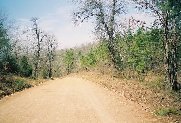
A typical road (Manfred
Rd, west of Norman) in the area in March 2008.
Note how dry the area is, the undergrowth, the dead trees and the width
of the road.
SOUTHERN FIRES KEEP CREWS AND
AIRCRAFT BUSY
SO # P-Code Date 	District IQCS and Incident Numbers 	   Fire Name
41 P8CD5X   3/13/2006 	CAD/WOM  IQCS ID 00000059293 AR-OUF-006291 NO MANS LAND
MARCH 16 -- TULSA, OK: The Southern Area Coordination Center
(SACC) reported that initial
attack yesterday included over 200 fires in Florida, Mississippi, North
Carolina, Oklahoma, Tennessee, and Virginia. The No Man's Land Fire in
Arkansas was at 300 acres this morning with zero containment, and
reported tonight at 2,000 acres with 20 percent containment.
The fire started on Monday in Montgomery County west of Little Rock
and had air tankers on it today after proving a challenge yesterday; it's
burning in heavy fuels with thick underbrush, and yesterday burned
through retardant lines and jumped fire lines. The fire's in steep rocky
terrain in a remote area with difficult access. The fire's burning in hardwood litter and deadfall from the
ice storm
that hit the area hard almost six years ago, with six or eight feet of
brush growing up since then through the deadfall of the 2000 storm. More than 50 personnel are assigned to the fire.
Hot Springs, AR - A large wildfire on the Ouachita National Forest in
Montgomery County continues to burn. The fire, named "No Mans Land
Fire", is located on the Caddo/Womble Ranger District, 7 miles west of
Black Springs and south of Highway 8. The fire was 65% contained as of
Saturday morning. It is expected to be 100% contained by nightfall.
Lightning is believed to have caused the fire, which has already burned
approximately 8,000 acres.
Current resources working this fire include helicopters from the Mena
Helibase, tankers and lead planes from Ardmore, Oklahoma, dozers,
engines, and 75 personnel including two firefighting crews along with
local resources.
Ouachita wildfire burns 10,000 acres
Posted on 3/17/2006
by Sandra Kirk
The Ouachita National Forest is dealing with its largest wildfire in
over forty years.
The fire has spread across Montgomery County south of the communities of
Norman and Black Springs along Highway 8 about 50 miles west of Hot
Springs. By late Friday It had grown to a size of nearly 10,000 acres.
What started with a lightning strike last Sunday and a 10-acre fire grew
rapidly late this week. Jim Burton with the U.S. Forest Service says
when the wind changed yesterday fighting the flames became much more
difficult.
"There is backcountry here, real steep and rocky. We've had a lot snags
to contend with so we've had a hard time getting it contained. So we've
backed off to the roads that surround the area," says Burton. This is the largest fire in the Ouachita National Forest
since the early 1960’s and is highly unusual. However, a large build up
of fuels over several decades combined with a severe ice storm six years
ago, allowed the fire to spread.
Forestry Service firefighters from the state of Washington worked all
day setting a nearly eight mile backline of fire to try and contain the
blaze. Dubbed the "No Man's Land Fire" because of the rugged and remote
terrain, it has grown to a size threatening homes in the area.
"It was in the middle of nowhere, but it has progressed out into
civilization,” says Burton. “Here along Highway 8 near Norman and Black
Springs there are several residences, we have contingency lines around
all of those."
The Forestry Service considered the wildfire still uncontained late
Friday, but by mid day Saturday they anticipate that will change for the
better. Monitoring will continue over the weekend, and forecasted rain
will help bring it fully under control.
A forest fire that had been growing slowly all week exploded into a
remote and rugged part of the Ouachita National Forest on Friday,
consuming thousands of acres, a U. S. Forest Service official said.
The fire, triggered by lightning Sunday, had burned 800 acres by
Thursday and Forest Service officials had expected it to grow, U. S.
Forest Service spokesman Debbie Ugbade said. And grow it did. By early Friday evening the fire, named No Man’s Land
for its remote locale, had ravaged 5, 000 to 7, 000 acres, Ugbade said.
“Our priority is still protecting people and property,” she said.
Fire crews took steps to protect 10 homes and a church, she said, but no
evacuations were ordered.
“It is the largest fire on the Caddo Ranger District in history and
possibly on the forest since 1960 s,” Ugbade said of the fire seven
miles west of Black Springs in Montgomery County.
The blaze was expected to grow to 10, 000 acres before crews could
contain it. By late Friday the fire was 35 percent contained.
Ugbade said the fire should be contained this afternoon with some help
from Mother Nature. “I hope we have rain,” she said.
In the meantime, fire crews from Oklahoma and Washington along with 15
to 20 employees from the Natural State were using backburns and relying
on rural roads for break lines, Ugbade said.
Helicopters from the Mena Helibase dropped water, and large Forest
Service tankers capable of dropping 2, 500 gallons of retardant, made
drops as well. Ugbade was not sure how many drops were made Friday but
said the tankers made four drops Thursday.
“We’re mostly fighting it from the air because of the rough terrain,”
she said. “We can’t actually get in there to fight the fire.”
Wildfires have plenty of dry timber and brush to feed off, but rain
expected this weekend should ease conditions. Last year was the
second-driest on record, prompting burn bans across the state in
December and January.
During a typical year, wildfires burn about 9, 500 acres from January to
March, according to the Arkansas Forestry Commission. Through March 15
of this year, 21, 050 acres had burned. Wildfire season starts in
October and goes through the end of April.
The National Weather Service calls for widespread rain across the state
this weekend. But dry, cool weather should return by early next week.
The service was calling for a 90 percent chance of rain today and again
Sunday in the Ouachita National Forest, which includes parts of Garland,
Montgomery, Perry, Pike, Polk, Saline and Scott counties.
The national forest covers 1. 8 million acres, stretching from central
Arkansas to southeast Oklahoma. When there is a lack of rain, the fire
danger usually increases.
Beneficial rain fell in Arkansas on March 18th through the 20th. It was
the biggest rainfall event of the year thus far, with 3 to 5 inch
amounts common in much of southern Arkansas. Parts of the southwest
received over 6 inches. By contrast, precipitation was limited in
northern and eastern sections of the state...with less than an inch of
rain reported in some cases.
Mt Ida 5.67" Seventy two hour rainfall totals through 12 am CST on
03/21/2006.
U-S Forest Service spokeswoman said the
fire was started by lightning last Sunday. She said it had burned about
800 acres by Thursday in an area west of Black Springs in Montgomery
County, but then spread rapidly yesterday.
Jim Burton, fire team leader for the Forest Service in Oklahoma and
Arkansas, said conditions in the forest allowed the fire to expand
rapidly. He said the area had not had fire in it for decades. According
to Burton, some of the old-timers in the area say they haven't seen fire
on the mountains in at least 50 years. He said that had allowed a
tremendous amount of buildup of fuel on the forest floor.
Burton said the fire was likely to spread over about ten-thousand acres
before firefighters are able to contain it. But he said they hoped to
achieve that by tonight. As of mid-morning today, he said the fire was
60 to 65 percent contained.
Rains quench national forest wildfire by Katherine Marks, Arkansas
Democrat 3/21/2006 |