

ONSITE LINKS
Cemeteries
*Cecil *Cecil Chapel *Center *Foote *Nunley *Pleasant Grove/near Cove *Pleasant Grove/Big Fork *Westview *Witherspoon/Vandervoort Abstracts
from Church Registers of The Cherry Hill Methodist Episcopal Church South
Towns and Townships of Early Polk County Early Polk County Physicians and Business Men
|
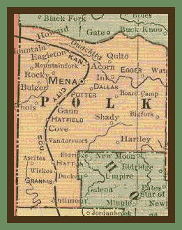
A Brief History of Polk County On November 5, 1844, James K. Polk, of Tennessee, was elected President of the United States, and on the 30th of the same month Gov. Thomas S. DREW approved an act of the Arkansas Legislature cutting off a large part of Sevier County and erecting it into a county named after the President-elect. It is one of the western tier of counties; bounded on the north by Scott county; on the east by Montgomery; on the south by Howard and Sevier, and on the west by the State of Oklahoma. It has an area of 846 square miles and an average elevation of 1,300 feet, drained by the Cossitot and Ouachita rivers, both of which rise in the county. The act creating the county fixed the temporary county seat at the house of John PIRTLE, where there was a post office called Panther. The permanent county seat was located near the southwest corner of Township 2 south, Range 30 west, and was named Dallas, for the Vice President of the United States. Subsequently it was removed to a site a short distance north and the name was changed to Mena. Polk is divided into seventeen townships, viz: Big Fork, Center, Cedar, Cove, Eagle, Eagle Gap, Faulkner, Freedom, Fulton, Gap Springs, Mill Creek, Mountain, Ouachita, Ozark, Potter, Rich Mountain and White. A large part of the county is in the Arkansas National Forest.
Neighboring Counties
Welcome to Polk County. Appreciation to Jerry and Linnie Howell,
previous County Coordinators for all their work obtaining and uploading information to this website!
|
OFFSITE LINKS |