Lands in James Township of Scott County
Researched & Submitted by Charlene Holland
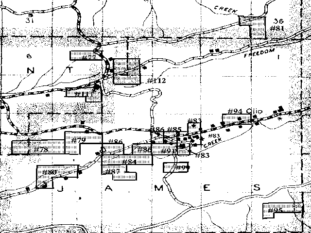
I found seventeen land records for some of the families in the 1900 James Township census. I have attempted to show on this 1936 Arkansas Transportation Department map where those lands were located. They will be shown on the map as numbers corresponding with the dwelling numbers in that 1900 census. Other families more than likely owned land in that area, but I was unable to find records. At this time, these lands most likely do not belong to those same families. William P. Morrow, for instance, sold his land in 1903 to George W. Terry, and moved to the Nola area.
A "Section" of land equals one square mile or 640 acres. A "Township" contains 36 sections and is 36 square miles. A "Range" is a North and South strip of Townships, each 6 miles square. A quarter of a section consists of 160 acres, a half of a quarter is 80 acres and a quarter of a quarter of a section consists of 40 acres. You will see records that give location such as SWSW or SWNE. This means southwest quarter of southwest quarter and southwest quarter of northeast quarter. The Ranges in Scott County go west to east as 26 West to 30 West, and Townships from south to north 1 to 5 N.
The dictionary describes a "township" (Abbreviated as t., T., twp., tp.) as:
I may have oversimplified these descriptions, but when I first started researching my family I had a hard time figuring out the difference between what I saw in a land record and what I saw in a census record.
Dutch Creek runs about 18 miles in a northeasterly direction from Lamb to Blue Ball in Scott County and on into Yell County. Many of the people that live in that area still says that they " live on Dutch Creek." The first factual location of the Olio post office was given by Lurilla L. Tate, widow of William L. Tate, who was postmaster from 1868 to 1872. She said it was located in the South East quarter of Section 7, Township 3 North, Range 26 West. This is one half-mile southwest of Union Hill Cemetery, 18 miles east of Waldron and 12 miles west of Walnut Tree (now Waltreak). She said it was on Dutchess Creek. Dutch Creek shown on the original survey of 1840 was called Dutchess Creek. Part of this area was also called "Lick Skillet". It was that area where the old Danville Road crossed Dutch Creek in the South West quarter of the South East quarter of Section 15 Township 3 North Range 27 west.
On 23 April 1945, H.L. (Hillery L.) Wilson gave the location of Olio Post Office as being in the North East quarter of the North East quarter of Section 13, Township 3 North, Range 27 West on Dutch Creek, 20 miles to Waldron and 7 or 8 miles from Blue Ball. This is one and one half miles west of Union Hill Cemetery on State Highway #80.
This community was also called Hale Town because of the many Hales living there and the prominence of Roe (Jethro) Hale in business and politics.
The area was also called Mount Moriah for the church and school in School District #5. This school and church was located on the East end of a hill in the Northwest quarter of the Southeast quarter in Section 15 Township 3 North of Range 27 West. That is a half mile due south from today’s Mount Moriah church.
The families whose records I found are as follows:
Thomas Olive #77
The North half of the Southeast quarter of Section 5 of Township 3N of Range 26W
consisting of 80 acres signed February 29, 1892
James E. Cox #78
The South West quarter of the South West quarter of Section seventeen and the South
half of the South East quarter and the South East quarter of the South West quarter of
section eighteen in Township three North of Range twenty seven West of the Fifth Principal
Meridian in Arkansas, containing one hundred and sixty (160) acres. These papers were signed
on June 16, 1905
Joel Cox #79
The North half of the Southeast quarter and the east half of southwest quarter both in
Section 17 of Township 3 North of Range 27 West of the 5th Principal Meridian consisting of
160 acres in Scott County. Signature date was June 30,1906
John Hale #80
The Southeast quarter of the northeast quarter of Section 19 of Township 3 North, Range
27 West, and northeast quarter of the southeast quarter of Section 19 of Township 3 north,
Range 27 west and the south half of the northwest quarter of Section 20 of Township 27 west
of the 5th Principal Meridian consisting of 160 acres in Scott County
Thomas Johnson #81
The Northeast quarter of the southeast quarter of Section 35 in Township 4 north, Range
26 west and the west half of the southwest quarter of Section 36 of Township 4 north, Range
26 west of the 5th Principal Meridian, consisting of 120 acres in Scott County. Final document
was signed October 17, 1888.
John Louis James #83
The Southeast quarter of the northeast quarter, the northeast quarter of the southeast quarter and the west half of the southeast quarter of Section 15 of Township 3 north of Range 27 west of the 5th Principal Meridian, consisting of 160 acres in Scott County. This document was signed August 6, 1896.
Israel Brothers #84
This land was located in the north half of the north half of Section 21 in Township 3
north of Range 27 west of the 5th Principal Meridian, consisting of 160 acres. Final
Homestead document is dated August 15, 1888.
George W. Terry #85
This land was located in the northeast quarter of the southwest quarter and the
southeast quarter of the northwest quarter of Section 15 in Township 3 north of Range 27
west of the 5th Principal Meridian in Scott County, consisting of 80 acres. The final
document was signed on November 11, 1896.
On November 17, 1903 George W. Terry bought two parcels of land from William Preston Morrow for the total amount of $800. This land was located in northwest quarter of the southwest quarter of Section 15 in Township 3 north of Range 27 west of the 5th Principal Meridian containing 40 acres. He paid $300 for this portion. The other was located: "part of the Southeast quarter of the Southeast quarter of Section 16, and east half of the Southwest quarter of the Southeast quarter east half of the Southwest quarter of Section 16, and all that part portion of the Southeast of the Southeast Southeast quarter lying on the north side of Dutch Creek, all in section 16, and the east half or part of the Northwest quarter of the Northeast quarter of Section 21 all in Township 3 N Range 27 West containing 62 acres more or less. "
William Morrow #86
Homesteaded land located in the Northwest quarter of the southwest quarter of Section
15 in Township 3 North of Range 27 West of the 5th Principal Meridian containing 40 acres.
Final document signed May 15, 1894.
He bought land from Thomas Hamilton on January 24, 1887. It was located in the east half of the southwest quarter of the southeast quarter - of Section 16 and all that portion of the south east of south east quarter lying on the north side of Dutch Creek all lying in Section sixteen in Township 3 north of Range 27 west containing in the aggregate 22 acres. The papers were filed on April 7, 1893 at 10 AM.
He bought more land from John Hamilton on March 14, 1892. This land was located: A part of the SE ¼ of the SW ¼ and a part of the SW ¼ of the SW ¼ of Section 16, in Township 3 North, Range 27 West, more particularly described as follows: Commencing at the channel of Dutch Creek (which creek runs east and west through said forties (?) on the east line of the SE ¼ of the SW ¼, running therein north on the east line of said last described forty to the north east corner thereof, thence west to the northwest corner of said SE ¼ SW ¼, thence continuing west 16 rods to a stone; thence south to the channel of said Dutch Creek; thence east with the channel of said creek to the place of beginning, containing 20 acres more or less, on north side of said. This deed was filed on April 7, 1893 at 10 AM.
William P. Morrow sold land to George Terry on November 17, 1903. Those deeds were filed July 23, 1917 at 2 PM. This land was described as: Part of the Southeast quarter of the Southeast quarter of Section 16, and east half of the Southwest quarter of the Southeast quarter of Section 16, and all that part portion of the Southeast of the Southeast quarter of Southeast quarter lying on the north side of Dutch Creek, all in section 16, and the east half or part of the Northwest quarter of the Northeast quarter of Section 21 all in Township 3 N Range 27 West containing 62 acres more or less.
&The second transaction between W. P. Morrow and George W. Terry was made on the same date and was described as: The northwest quarter of the southwest quarter of Section 15 in Township 3 North of Range 27 West of the 5th Principal Meridian containing 40 acres.
Jesse Freeman #87
This land was located on the south half of the northwest quarter, the northeast quarter
of the southwest quarter and the northwest quarter of the southeast quarter of Section 21
in Township 3 north of Range 27 west of the 5th Principal Meridian, consisting of 160
acres in Scott County. The final papers being signed February 29, 1892.
John Hamilton #90
Even though I was unable to find homestead or land records for John Hamilton, we know
that he owned land because of the land he sold to W.P. Morrow. That land was described as:
A part of the SE ¼ of the SW ¼ and a part of the SW ¼ of the SW ¼ of Section 16, in Township
3 North, Range 27 West, more particularly described as follows: Commencing at the channel of
Dutch Creek (which creek runs east and west through said forties (?) on the east line of
the SE ¼ of the SW ¼, running therein north on the east line of said last described forty
to the north east corner thereof, thence west to the northwest corner of said SE ¼ SW ¼,
thence continuing west 16 rods to a stone; thence south to the channel of said Dutch Creek;
thence east with the channel of said creek to the place of beginning, containing 20 acres
more or less, on north side of said creek This deed was filed also on April 7, 1893 at
10 AM.
James Terry #91
This land was located in the south half of the southwest quarter of Section 15 of
Township 3 North of Range 27 West of the 5th Principal Meridian containing 80 acres of
land in Scott County. This homestead was file at Dardanelle, Arkansas.
Jehu J. Wilson #94
Located on the North half of the northeast quarter of Section 14, Township 3 North of
Range 27 West containing 40 acres. Final document was signed August 20, 1884.
Elihu Bayrd #95
Located on the south half of the northeast quarter, the northeast quarter of the
southwest quarter, and the southeast quarter of the northwest quarter of Section 25 of
Township 3 north of Range 28 West. Signature date was April 14, 1906. This land was not
located in James Township.
Jesse James #99
This was a cash entry sale as compared to a homestead. This land was located in the
Southeast quarter of the northwest quarter and the southwest quarter of the northeast quarter
of Section 22 of Township 3 north of Range 27 west containing 80 acres
Thomas Hamilton #106
As I said with his son, Thomas did not homestead land, but we know that he did own
land as he sold some of it to W.P. Morrow. That land was located in the east half of the
southwest quarter of the southeast quarter - E ¼ of the SW ¼ - of section 16 and all that
portion of the south east of south east quarter - SE ¼ of the SE ¼ - lying on the north
side of Dutch Creek all lying in Section sixteen in township 3 north of Range 27 west
containing in the aggregate 22 acres. These papers were filed on April 7, 1893 at 10 AM.
William R. Vaughn #107
On September 4, 1882 William R. Vaughn and LuVicy Vaughn sold land to George W. Terry.
This deed was Acknowledged September 4, 1882 before Dolphus L. Brothers, J.P. and filed
and recorded December 22, 1883 by J.C. Gilbreath, Clerk. They received $200 for 160 acres
of land. The description of the land was: The southeast quarter of the northeast quarter
and the north half of the southeast quarter and the northeast quarter of the southeast
quarter all in Section 14 of Township 3 North of Range 27 West. At one time John W. Parker
owned this land. He homesteaded it with the final papers being signed June 20, 1876. I don’t
know when William and LuVicy Vaughn acquired the land. [See Endnote 2]
James Brooks #111
This land was located in the South half of the northeast quarter, the southeast quarter
of the northwest quarter and the northeast quarter of the southeast quarter, all in Section
8 of Town-ship 3 North of Range 27 West of the 5th Principal Meridian, consisting of 160
acres. Final document signed June 30, 1906.
Thomas Brooks #112
The Southwest quarter of the southeast quarter and the southeast quarter of the southwest
quarter of Section 4 and the northwest quarter of the northeast quarter and the northeast
quarter of the northwest quarter of Section 9, all in Township # North of Range 27 West of
the 5th Principal Meridian, consisting of 160 acres. The final land document was signed
March 30, 1905.
I have tried to be as accurate as possible locating the land on this map. This is just meant to give you an idea where your ancestors may have lived, not an actual land plat.
This map is taken from the 1936 General Highway and Transportation Map of Scott County Arkansas, prepared by the Arkansas State Highway Commission State-wide Highway Planning Survey.
A little additional information about Arkansas and Scott County of that era:
In 1890 there was 1,128,211 people living in Arkansas and in 1900 census showed that there
were 1,311,564 people living in Arkansas. [See Endnote 3] In 1910 Waldron had 900 people
living there. Ft. Smith had 23,975 and Little Rock had 45,941. Dardanelle had 1, 757 and
Gravelly had 210. Evidently Olio in James Township was too small to be counted for this
publication.
The Highway 80 of today that runs through James Township from Waldron was built in 1920 and Highway 250 from Waldron that runs through James Township was built in 1934.
The original James Township was formed in 1877 from territory taken from Hunt and LaFave Townships. The original voting precinct of James Township was in the home of James Terry. In 1882 it was relocated to the James School House (Mt. Moriah) - Southwest quarter of the southeast quarter of Section 15, Township 3 North, Range 27 West)
On May 22, 1882 the Scott County Courthouse in Waldron burned and all of the records were destroyed.
On August 7, 1882 the fifteen Political Townships of Scott County that had been created before the fire were defined and fixed: "Ordered by the court that the Township of James shall be composed of and embrace the following territory, to wit: All of Township 3 north Range 27 west." On that same date the County Court re-established the various Road Districts of Scott County.
Evidently there were three roads leading through James Township in 1882. The first one was the Waldron-Danville Road, which was from Waldron all the way to Danville in Yell County. This ran through Olio. The second one was Dutch Creek Road which rand from the western boundary of James Township and intersected with the Waldron-Danville Road near the South West quarter if the South East quarter of Section 15 in James Twp. The third one was called the Poteau and Freedom Road, which lead from the western boundary of the township and intersected with Dutch Creek Road, and from there to the Waldron-Danville Road. I suspect that the now Highway 250 runs fairly close to what was the Waldron-Danville Road, and Highway 80 was the Dutch Creek Road.
There is an excellent article written by John O’Nale in the 1999 Spring issue of the Scott County Historical Society’s Newsletter "Echoes". It gives you great information about how to read land documents. I would recommend it to anyone who is trying to figure out how to find their ancestor’s land on a map. I would also recommend the General Highway and Transportation Maps sold by the Arkansas State Highway Commission. I found the 1936 map easier to read than the more recent maps, but have both for reference.
Endnote 1: The American Heritage Dictionary of the English Language, Third Edition copyright 1992 by Houghton Mifflin Company. Electronic version licensed from INSO Corporation.
Endnote 2: Deed page 587-588.
Endnote 3: "The New Census Physical, Pictorial and Descriptive Atlas of the World" by E.G. Ravenstein, F.R.G.S. published 1911 The Reilly & Britton Company, Chicago.