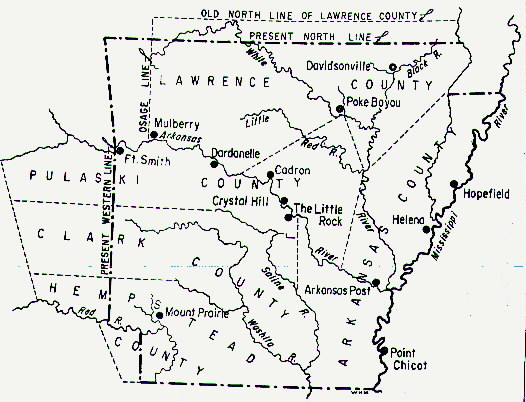
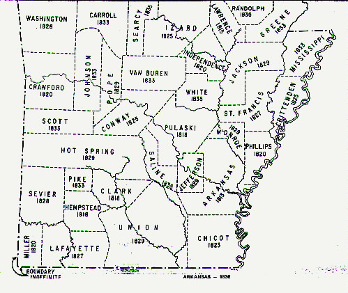
 | Arkansas |  |
| Arkansas | |


Barnishaw Cemetery
The Barnishaw Cemetery is located on the Old Military Road, Arkansas Highway 306, near Pine Tree, Arkansas. It is a well kept cemetery and listed on maps. Traveling from Forrest City, take Arkansas Highway 1 north to Colt, then turn west on Highway 306 and travel to Pine Tree. The cemetery is located about one mile past the Pine Tree Baptist Church. It is on the south side of the highway near the Arkansas Agriculture Experimental Station. Latitude 350723N, Longitude0905600W.
Bell Cemetery
The Bell Cemetery is located about 1 mile north of Palestine, Arkansasand Interstate Highway 40 on Arkansas Highway 261.
Beazley Cemetery-
The Beazley Cemetery is a family cemetery began on the property of George W. Beazley about 1865. The cemetery is noted on some maps as the Dennis Cemetery. The land was sold to Henry W. Dennis, who had married Rosa Goodloe Beazley, George W. Beazley's daughter, and the land became known as the "Dennis Place". There are no Dennis' buried here. The Beazley Cemetery is located 2.35 miles northeast of I-40 on Arkansas Highway 284 and lies about 330 yards west of the highway
Bible Union Cemetery
Bible Union Cemetery-
To reach the Bible Union Cemetery, travel north on Arkansas Highway 1 to Caldwell, then turn west on Arkansas Highway 261 and travel to the Community of Horton. The paved road ends at Horton. The cemetery is directly west of the road on a small hill. It is unkept and difficult to walk to.
Brown Cemetery
The Brown Cemetery is located north of Forrest City on the Barrow Hill Road. There is no road to this family cemetery. It is located on the back side of the Ridgecrest Country Club property. Latitude 350321N, Longitude0904551W.
New Casteel Cemetery
The current cemetery is located on Highwy 70 west of Forrest City, near the old Haven outdoor movie theatre. It is not on Find A Grave to the best of my knowledge.
Old Casteel Cemetery
The Casteel Cemetery is located on the St.Francis and Lee County Border off Highway 1 South, Arkansas. It has many graves that are not visible anymore, and includes both races! I believe it is probably the largest Cemetery in St.Francis County, and Lee County.
City, or The Old Forrest City Cemetery
The (Old) Forrest City Cemetery is located in the south part of Forrest City. To reach the cemetery, travel south on Arkansas Highway 1 to the road to the Forrest City Country Club. It is east of the Old City Library, and behind the Catholic Church on Highway 1 South. See attached letter asking for contributions for upkeep from the National Bank of Eastern Arkansas to help with expenses in addition to Ambrose McDaniel Trust Fund. A book with detailed listing of the burials including gravestones, obituaries, and biographys, is available on Amazon Books by me entitled "At The Top of The Hill". Note:FindAGrave is now adding the New Forrest City Cemetery records to this old cemetery. Most any burial since late 1999.
Clark Cemetery in Caldwell
Clark Cemetery in Colt
Clark Cemetery in St.Francis County
Elcannon Cemetery
Forrest City Cemetery-New cemetery
The Forrest City Cemetery is located in the south part of Forrest City. To reach the cemetery, travel south on Arkansas Highway 1 to Fletcher Road and turn west and travel less than 2 miles. The cemetery is on the east side of the road. Unfortunately, Find A Grave has consolidated these burials with the old City Cemetery, mentioned above. Most are since 1999 and are usually Clay Funeral Home, Woodhouse Funeral Home, or Peoples Funeral Home.
Forrest Park Cemetery
The Forrest Park Cemetery is located at the southern limits of Forrest City. To Reach the Cemetery, travel south on Arkansas Highway 1 to the city limits and the cemetery is on the west side of the highway.
Goodwin Cemetery
The Goodwin Cemetery is located about 15 miles southeast of Forrest City in the community of Goodwin. To reach the cemetery, travel south on Arkansas Highway 1 to US Junction 70 and turn west to Goodwin, then turn south on the gravel road next to the Baptist Church. The cemetery is located about 1 mile south on this road.
Harris Chapel Cemetery
The Harris Chapel Cemetery is located near Wynne and Colt.
Harris Family Cemetery
The Harris Family Cemetery is located 4.5 miles north of Forrest City on Arkansas Highway 284. It is on the Gregory Farm which is private property. There are only three headstones and it is believed that only eight graves are located here.
Hughes Cemetery-See note above, some gravestones are not visible.
The Hughes Cemetery is located north of Forrest City on the Barrow Hill Road. To reach this cemetery from Forrest City, go north on Arkansas Highway 1 to Barrow Hill Road and turn right. Continue on this road for about 4 miles until you come to a fork in the road, take the left fork for about 1 mile. Section 1 of Hughes Cemetery is on the west side of the road and section 2 and 3 are on the east side of the road. The Good Hope Presbyterian Church is on the east side of the road and next to sections 2 and 3.
Johnson Cemetery-Online
The Johnson Cemetery is located in Wheatley, Arkansas. To reach this cemetery from Forrest City, travel south on Arkansas Highway 1 to Junction US 70 and turn west to Wheatley. The cemetery is in the western part of the city. Latitude 345437N, Longitude 0910648W.
Linden Island Cemetery
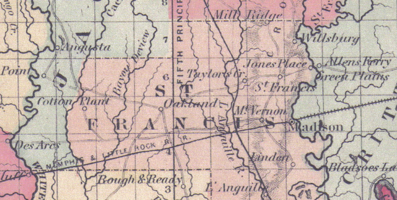
Per Kathleen Bell, at one time there was a town at Linden Island, located on the St.Francis River, It was a stopover and supply station for the steamboats that could travel as far north as Wittsburg in Cross County now, it has since disappeared. It is located off Hwy 1 South of Forrest City, turn east on Hwy 334 crossing Crowley's Ridge. At the end of the pavement turn left down the gravel road crossing the diversion ditch and from there you are in the area known as the Island! This was in 1980's.
Lindsey Cemetery
The Lindsey Cemetery is located north of Forrest City on the Barrow Hill Road. To reach this cemetery from Forrest City, go north on Arkansas Highway 1 to Barrow Hill Road and turn right. Continue on this road for about 4 miles until you come to a fork in the road, take the left fork for about 1 mile. Next to Hughes Cemetery above.Note:It is a fairly new cemetery.
Loughridge Cemetery
This is one of the oldest cemeteries in Cross County, on the county line (The Loughridge Cemetery is a stones throw across the St. Francis County Line and located on the west side of AR 284 in Cross County.) Directions: From US Highway 1 at Colt, turn east on Highway 306. Travel 5 miles to Highway 284. Turn north on Highway 284, and travel about ¼ mile towards Village Creek State Park. Just at the Cross/St. Francis County line, a road turns left (west) off the highway. The cemetery is adjacent to the county line and is visible from the highway.
Madison Cemetery
The Madison Cemetery is located in the community of Madison at the top of Crowley's Ridge and south of US Highway 70. The cemetery is unkept and can only be viewed during the winter months when the kudzu is dead.
McDaniel Cemetery
The McDaniel Cemetery is located near Forrest City. It is believed to be on the McDaniel Property owned by Johnny McDaniel, near Bonair, which once was called McDaniel
Mt. Vernon Cemetery
Mt. Vernon Cemetery is a very old cemetery. It was begun when the Town of Mt. Vernon was located nearby by the Mallory family. Mt Vernon disappeared but the cemetery remained. The cemetery is well kept. To reach the cemetery, go north on Arkansas Highway 1 to Arkansas Highway 284 and turn east, go to the top of the ridge where you will find a historical marker which is located on the cemetery grounds.
Roy Cemetery
To reach the Roy Cemetery from Forrest City, go north on Arkansas Highway through Caldwell, Arkansas to Telico Road and turn right. The cemetery is in a field on the left side of Telico Road.
Old Mt.Zion Cemetery
Scott Bond Cemetery
The Scott Bond cemetery is located in Madison, Ark. (Included with Madison Cemetery above), which could be the same cemetery
Shady Grove Cemetery--Note:ON Find A Grave, There are many Shady Grove Cemeteries
Shady Grove CemeteryThis cemetery is located near Heth
Stanley Cemetery
This cemetery is located near Caldwell
Old Shields Cemetery
This cemetery is located 2.7 miles west of Colt, Arkansas on the north side of Arkansas Highway 306, The Old Military Road. This cemetery was abandoned many years ago.
The Waldrop Cemetery
The Waldrop Family Cemetery is located on the east side of Wheatley, Arkansas, north of old U.S. Hwy.70. It has been neglected and it is difficult to tell how many graves are there, but it is said that more are buried there than these below. Per Kathleen Bell, 1988.
The Widener Cemetery
The Widener Cemetery is west of Widener, Arkansas. To reach the Cemetery you can take Interstate 40 or US 70 east to Arkansas Highway 38and turn south to Widener. In Widener take Arkansas Highway 50 east for about 1/2 mile. The cemetery is on the north side of the road.
Wylds Cemetery
The Wylds Cemetery is located south of Forrest City about 9 miles from the junction of Arkansas Highways 1 and 334 and near the end of Arkansas Highway 334. The cemetery is unkempt and located on private property.
Yarbrough Cemetery
The Yarbrough Cemetery is located 2.9 miles east of Colt, Arkansas on Arkansas Highway 306, The Old Military Road. The Cemetery is on the north side of the road on a hill.
Yocona Cemetery-AKA Yacona and Hodges, pronounced Yakg'one per Glenn Hammons
The Yocona Cemetery can be reached by traveling west on US 70 to Yocona Road, go south on Yocona until the end of the paved road. Turn right on the gravel county road and it is on the left side shortly thereafter, probably on private property. The cemetery has large cedar trees along the road and can be easily seen from Yocona Road. You are close to the county line
YEAR MONTH DAY1881 3 1 -86 -10 -13--------------------
Since the numbers below are larger than those on top for both the month and day, you will have to borrow from the figures at the left just as you do in normal substraction. However, you cannot simply borrow 30 days if the month happens to have 31, 28, or 29 days for leap year.
The month on the top line is March and it has 31 days. Therefore you add 31 to the day shown making 32 days. That leaves 2 in the center, so you borrow 12 months from the year 1881. Now your substraction problem is much simpler:
YEAR MONTH DAY1880 14 32 -86 -10 -13--------------------1784 4 18This individual's birth date is 18 April 1784.