
Towns & Communities
Road Map of VBC.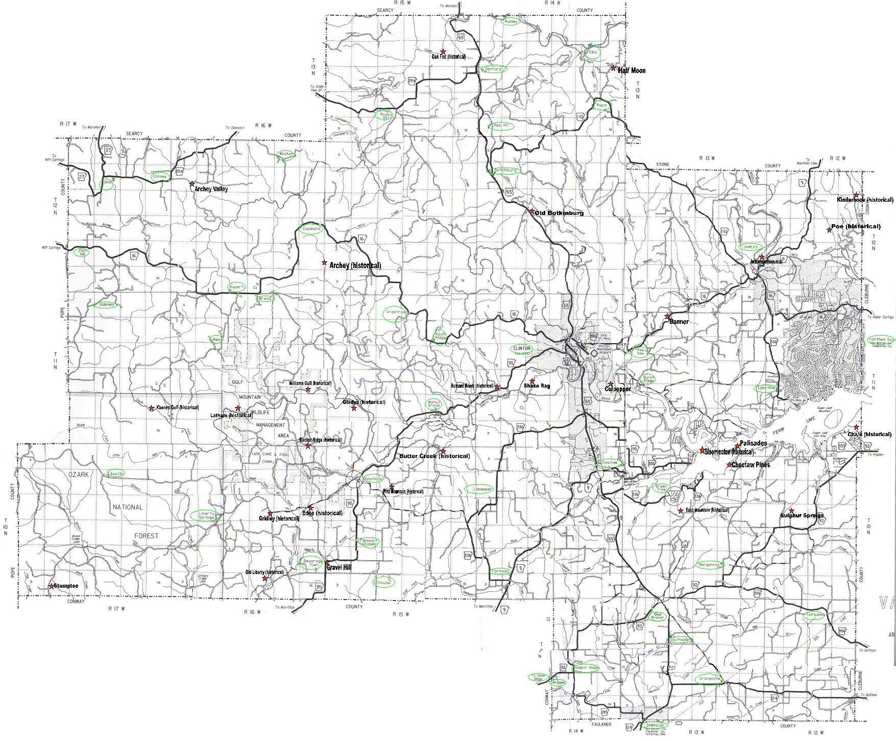
| Information Links | Plat Map Links |
| Alread | S3 T11N R16W |
| Archey (historical) | S30 T12N R15W |
| Archey Valley | S7 T12N R16W |
| Austin | S10 T10N R17W |
| Banner | S8 T11N R13W |
| Bee Branch | S5 T9N R13W See Greasy Valley |
| Beverage Town | S25 T10N R16W |
| Bloomington (historical) | S3 T10N R13W |
| Botkinburg | S7 T12N R14W |
| Brock Creek | |
| Burnt Ridge | S18 T11N R13W |
| Butter Creek (historical) | S2 T10N R15 |
| Buzzard Roost (historical) | S19 T11N R15W |
| Chalk (historical) | S34 T11N R12W |
| Chimes | S12 T12N R17W |
| Choctaw | S1 T10N R14W |
| Choctaw Pines | S11 T10N R13W |
| Claude | S33 T10N R15W |
| Clinton | S15 T11N R14W |
| Copeland | S24 T12N R16W |
| Crabtree | S3 T11N R15W |
| Crossroads | S5 T9N R13W |
| Culpepper Mtn | S24 T11N R14W |
| Dabney | S3 T11N R17W |
| Damascus | S32 T9N R13W |
| Dennard | S19 T13N R14W |
| East Mountain (historical) | S21 T10N R13W |
| Edge (historical) | S13 T10N R16W |
| Eglantine | S19 T11N R12W |
| Elba | S14 T13N R14W |
| Fairbanks | S5 T9N R12W |
| Fairfield Bay | S16 T11N R12W |
| Formosa | S32 T10N R14W |
| Gladys (historical) | S29 T11N R15W |
| Gravel Hill | S30 T10N R15W |
| Gravesville | S26 T9N R13W |
| Greasy Valley | S5 T9N R13W See Bee Branch |
| Green Tree | S8 T10N R13W |
| Gridley (historical) | S15 T10N R16W |
| Halfmoon | |
| Kinderhook (historical) | S15 T12N R12W |
| Koch Ridge | S11 T11N R15W |
| Koones Gulf (historical) | S25 T11N R17W |
| Latham (historical) | S28 T11N R16W |
| Liberty Springs | S17 T10N R17W |
| Martinville | |
| Massey Mountain | |
| Morganton | S26 T10N R13W |
| Nogo | |
| Oak Flat (historical) | S14 T13N R15W |
| Old Botkinburg | S16 T12N R14W |
| Old Liberty (historical) | S34 T10N R16W |
| Old Rattlesnake | |
| Owl's Cove | |
| Palisades | S2 T10N R13W |
| Pee Dee | S7 T11N R13W |
| Pine Mountian (historical) | S9 T10N R15W |
| Plant | S26 T13N R14W |
| Pleasant Grove | S20 T10N R15W |
| Poe (historical) | S21 T12N R12W |
| Rabbit Ridge | S23 T9N R14W |
| Racket Ridge (historical) | S36 T11N R16W |
| Red Hill | S31 T13N R14W |
| Rex | S8 T11N R16W |
| Rocky Hill | S28 T13N R15W |
| Rumley | S8 T13N R14W |
| Rupert | S33 T12N R16W |
| Scotland | S8 T10N R15W |
| Settlement (historical) | S25 T12N R13W |
| Shake Rag (historical) | S21 T11N R14W |
| Shirley | S25 T12N R13W |
| Southside | S9 T9N R13W |
| Steel Chapel | |
| Stumptoe | S32 T10N R17W |
| Sulphur Springs | S20 T10N R12W |
| The Gulf | |
| Una | S10 T12N R17W |
| Walnut Grove | S26 T11N R15W |
| Whipple | S27 T9N R14W |
| White Oak Mtn Community | |
| Williams Gulf (historical) | S24 T11N R16W |
| Woolum | S2 T12N R16W |
| Zion Hill | S28 T12N R17W |