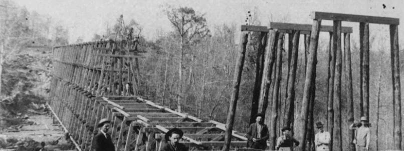
Photo courtesy Leon Van Patten from Ray D. Raines collection
Patton Hollow, Pangburn. Building the Patton Hollow Trestle
in 1907. In 1910 or ’11, the structure was declared unsafe
and the trestle was filled in with dirt.
T he story of this lost mine began with a piece of lead ore given me when I was eight years old by an old timber cutter named Matthew Rouse. Years before, his father had dug it from the side of a mountain about five miles west-southwest of Pangburn, Arkansas.
The existence of a lead mine in the area was accepted
by old-timers, but no one seemed to know its exact location.
This came to light in 1939, the year I married.
 My wife and I moved into an apartment belonging to a widow, Aunt Mishie Porter
[photo, left]. She was the daughter of Johnny Patton, a settler
on Little Red River before the Civil War. Aunt Mishie was very
old, but she told me many stories of her childhood in Patton Hollow,
including this one concerning Lt. Shon Haas, a Union soldier under
Gen. Samuel Curtis.
My wife and I moved into an apartment belonging to a widow, Aunt Mishie Porter
[photo, left]. She was the daughter of Johnny Patton, a settler
on Little Red River before the Civil War. Aunt Mishie was very
old, but she told me many stories of her childhood in Patton Hollow,
including this one concerning Lt. Shon Haas, a Union soldier under
Gen. Samuel Curtis.
In the spring of 1862, Gen. Curtis was camped on the north bank of White River, a short distance from Batesville. His troops were exhausted from the long trek across the Ozark Mountains after the battle of Pea Ridge. Though the battle was considered a victory, it had been a disaster for Curtis and his Union soldiers.
Provisions for both men and animals had been depleted. It was time to stop and scrounge for supplies.
Col. Osterhaus was Curtis’ principal forager, but the poor and desolate mountains of northern Arkansas yielded little sustenance for such a huge army. However, Osterhaus learned that starting 20 miles below Batesville lay miles of rich, fertile land capable of providing great quantities of precious provisions. With 600 men, he headed south toward Little Red River.
Before he reached the river, the colonel learned that his information was correct. Smokehouses were full of meats and dried fruits, pastures abounded with fat cows, and barns contained hay from last year’s crops. He had found the land of plenty. Here he headquartered, naming the site Camp Lyon.
To his surprise, Osterhaus learned of a lead mine some 25 miles south of Camp Lyon. At this time lead was desperately needed by the Confederates. Osterhaus decided to reconnoiter the mine, to see whether the Union should mine the lead for its own use, or destroy it to keep the ore from enemy hands.
A nearby ferry owner admitted the mine’s existence. But he said he had never been there, as friends and neighbors always brought back enough ore to divide with him. He said about four miles upriver was a religious settlement whose people often went to the mine.
Col. Osterhaus dispatched 12 men to move upriver and search for the mine. Lt. Shon Haas was placed in command and warned not to use force against the settlers. Should he need food or hay, Haas was to pay for it in gold and not issue the usual promissory notes. There would be no record kept of this mission as it might prove a failure.
Osterhaus moved south loading wagon after wagon with meats, sorghum, corn and hay, headed toward Curtis’ headquarters. A United States Promissory Note was issued to everyone whose goods were confiscated.
On May 19, 1862, Osterhaus crossed the Little Red River and four days later arrived at Searcy Landing. He immediately ran head-on into Col. Johnson and his Texas Cavalry, and a furious battle ensued. This was the Battle of Whitney’s Lane. Osterhaus lost 100 men who he buried in a trench along the river bank. As soon as he could regroup, he headed back for Camp Lyon.
In the meantime, Shon Haas and his men were having to travel slowly because of virgin growth along the river. Finally, they rounded a mountain and emerged abruptly into a cleared valley. To the right ran the river and ahead and to the left stood majestic green mountains. The field was planted in corn.
Haas led his detail around the field toward a group of cabins. They were met by three men, seemingly all in their 50s. A dozen or so small children huddled together, watching wide-eyed.
Lt. Haas learned the settlers were a group of Presbyterians from Tennessee. No Confederate soldiers were there, but several wives, mothers and sweethearts of soldiers had come from surrounding settlements in search of a refuge. Haas asked permission to camp nearby until morning.
The leader of the settlement was a man named Johnny Patton. He had come to the valley 15 years before, he said, to make a new home for his family and several followers of the same faith. They built the cabins and cleared the land. Another of the men was Jones Watson, who lived a mile around the mountain in a settlement known as Judson (now Pangburn).
The lieutenant asked Patton about the lead mine. Patton said there was such a ledge five miles to the southwest. He said Osage Indians used to tell of a great trembling of the earth many years before that left a ledge of pure silver uncovered.
Hearing of the silver, Patton and Jones Watson made a trip to the site. They found the alleged silver to be lead – but of unbelievable quality.
The old man went into his cabin, returning with a chunk of ore about three inches square. He placed the lead on the soldiers’ cookfire and Haas saw it slowly melt and trickle into the blaze.
Patton said the last time he had visited the mine, someone had dug back into the hillside and it was caving in. Part of the vein was still exposed. He figured Searcy Border Rangers (Home Guard) had dug the ore out, as a number of wagon tracks could be seen in the ravine below.
Haas asked Patton for directions to the mine, and they were readily given. Early the next morning, the lieutenant and his men were up and heading out of the valley. After about three hours, they came upon the summit of a much higher mountain that broke suddenly into a deep ravine. Far below they could hear water tumbling over a fall.
Across the ravine was the disturbed earth Patton had mentioned. To the right Haas could see the dull shine of the exposed ore.
Haas crossed the ravine to examine the vein more closely. He judged it to be about six inches wide at the surface, angling slightly downward into the mountain. He calculated there was an unlimited amount of ore. But because of the rough terrain, he did not think it could be mined profitably – by either the North or the South.
Before nightfall Haas and his men were back at the settlement. Haas talked with Patton, telling him of his findings. It would be senseless to encourage his superiors to fortify the diggings, he said. Neither would he advise using demolitions to destroy the mine, as he did not think it would be valuable to the Confederates, either.
Next morning, the two men shook hands and the Union detail left. Haas told the old man he hoped their next meeting would be more pleasant – and sooner than anticipated.
Haas did return to Patton Hollow, but not for long. It seems he saw one of Aunt Mishie’s older sisters, and it was love at first sight. Unfortunately, when he returned she was already married to someone else.
Aunt Mishie told me the mine was in Waterfall Hollow. I have been there many times but have failed to find any clue as to its whereabouts. This past winter I was looking over a geological map of West Pangburn Quadrangle, and to my surprise found not one but two Waterfall Hollows. They lie parallel and only abut two miles apart.
At my age I have lost the desire to hunt for this lost mine, but it could be an adventure for a younger treasure hunter.