Maps

Township Maps


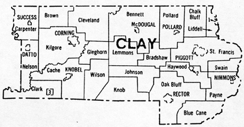
This township map comes from the book,
Arkansas Township Digest: Minor
Civil Divisions, 1820-1990, compiled by Desmond Walls Allen. The book shows how townships developed, grew, changed, split apart and
evolved just like counties. It is available from Arkansas
Research.
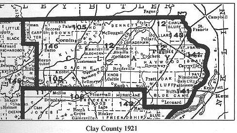
Also, here is the 1936 Detailed Township Map
from the Arkansas State Highway Commission. (This map is
very large, but is so detailed that individual rural houses are shown.)

Other Maps
- 1927 Flood Map -
NEW!!!
- Arkansas State Maps
Arkansas County Formation Maps
Arkansas Census Maps 1820-1930
-
State of Arkansas, ca. 1892 International Cyclopaedia: Vol.
1, Dodd, Mead & Company
State of Arkansas, County outline map, U.S.
Census Bureau, 1990 (84k)
-
South Central United States, circa 1897, includes Arkansas, Louisiana, Mississippi and Alabama. Redway and Hinman, American Book
Company (510k)
- 1895
Arkansas Map (very large file)
- Shaded
Relief Map of Arkansas (Click
here for the same map with county lines.)
- Recent
Earthquakes in the Central U.S. (This is an eye-opener.)

Updated 11 Jan 2007