Flash flooding / Tornados
For Memorial Weekend the weather was beautiful. On 26th May 2013, Sunday afternoon, we loaded up the canoes and headed to the Ouachita River for a float trip. Map. We have our own canoes but others had rented canoes Ric at M& M Canoes at Pencil Bluff and at the Spurling's at Riverview Cabins and Canoes. The river was up and rolling very nicely but still very clear and clean. We must have passed twenty-five canoes and kayaks between our put under the Oden bridge and our take out, ten miles down stream passed a low water bridge, the Boy's Camp and under the bridge on Hwy 270 at Rocky Shoals. It only took us just a little under three hours. Usually takes five hours. It was all fun and we were the only ones to finish without getting wet unintentionally – as usual. Spoke to the Park Rangers / Wildlife Officers for about five minutes at Rocky Shoals, they had just pulled in as we were finishing loading and trying down our canoes. Probably checking us out and everyone else to see if we had a stringer of fish. There were locals on the river fishing in their own canoes.
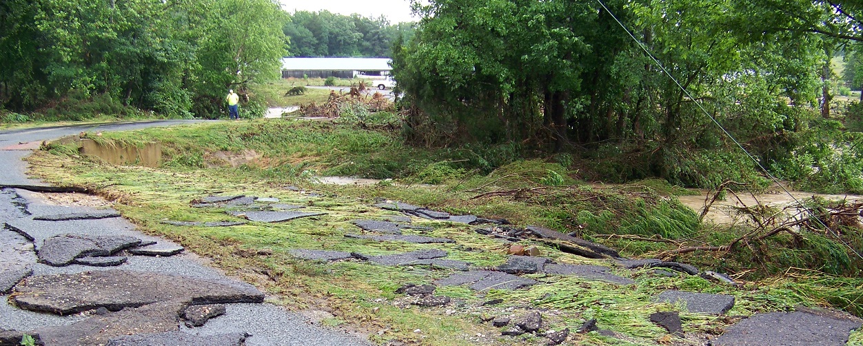
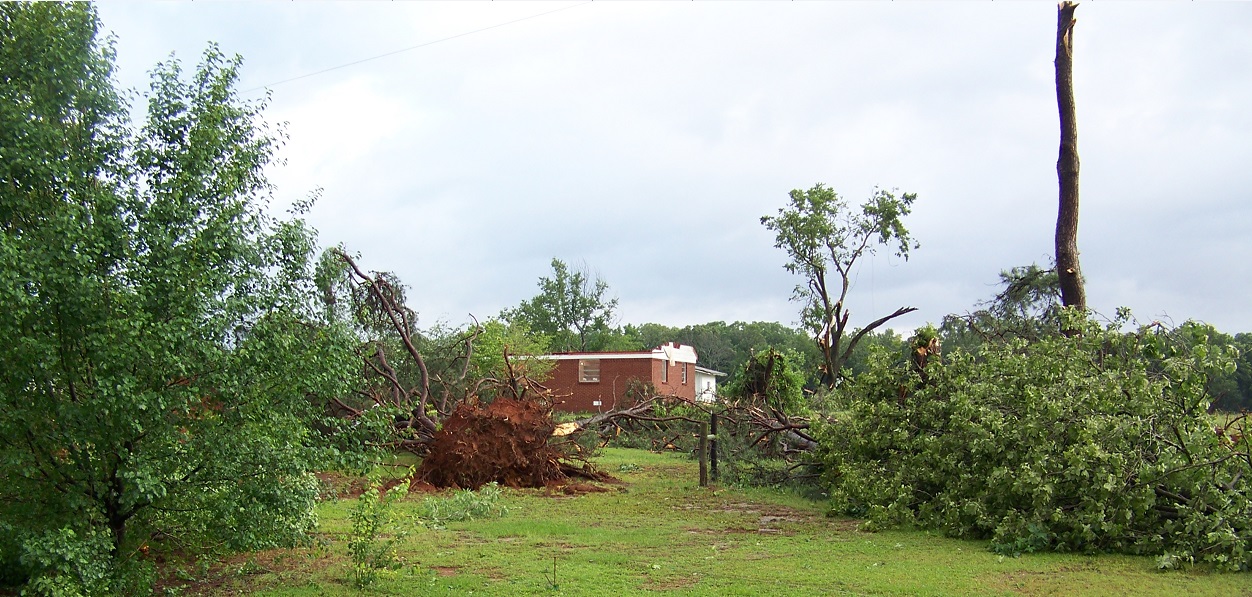
Areas of Ouachita National Forest experienced several bouts of severe weather in
the last couple of days of May 2013 including tornadoes and flash flooding. Big
Brushy Recreational Area was sweep. The picnic and campground area flooded. The
playground damaged. So Big Brushy is closed probably for good. It wasn't used by
many.
A thrill a minute!
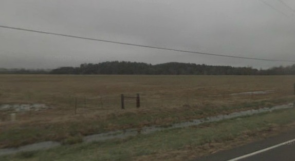
Five days later damaging storms pounded several regions of the U.S. during the final week of May 2013. Violent winds, flooding rains and tornadoes all left their mark as the month wound to a close, impacting areas including Oklahoma City, St. Louis, Little Rock and Montgomery County, Ark. A couple in Pencil Bluff survived when the waters from Brushy Creek washed their fifty year old home home off the foundations. The nearby Brushy Creek rose to dangerous levels. At 2.15am Thursday, 31st May, David Lebow heard a loud noise and thought he better go and move his lawn mower as the creek might rise but he couldn't get the doors open due to the water pressure on the outside and water was already half way up to his knees. The four days before we had seen him outside mowing his lawn. The house started to shift so he told his wife to hold on. The house moved 300 yards until it slammed into a tree. They held on until the water was too high inside the house them they swam to a nearby tree and held on for He sits on the cinder block wall. The house stopped when it slammed into a tree 300 yards below. David and his wife stayed inside the house until the water got to neck level them swam out to a nearby tree until dawn two and a half hours later. They were 11 feet up the tree. David said I am here that is all that matters and my wife and my relatives, we didn't loose anybody. Jack Vincent who has lived next door all his life couldn't believe it. As far as I know, the river did not get anywhere near going over the bridge on 270. On 3rd June, on the way into Mt. Ida, heading east, the big field to the left of the bridge (Standridge’s hay field) and did see where the water had washed down the standing hay just a little on the river side for maybe 75' or so into the field but it didn’t appear to have been that big a deal.
Y-City is horrible, it even got up in the cemetery, and over the highway knocking out the station and other things.
What is a big deal is what the flooding at Y City did, Scot County. We were told that ALL the older houses that are on the right side of the road on Hwy 270 just as you are coming up to the intersection of Hwy 71 are gone. They were washed away. Those little old houses have been there for generations. They say the only house that remained is a newer brick house that was on down the road a ways and it would be slightly above the level the others were on. We were also told that there was about 2' of water in the truck stop at Y City during the worst part of the flooding there. The Montgomery County Road Department worked all through the flooding, including the weekend, with their big trucks, graders, and backhoes doing repair work on the county roads that were washed out. A lot of the bridges had the approaches washed out and those had to be repaired before the road could be reopened to traffic. There were also several places in the county where the highways were flooded and they were shut down until the water went down. We heard that there was a woman stranded in her car on the Manfred Road bridge across the Caddo River at Caddo Gap. It seems she had seen a log truck or two cross the flooded bridge and she decided if they can do it so could she. Needless to say, she didn’t make it. She was rescued before she was swept off the bridge. The road was then barricaded. B.G. 3 June 2013
ArkansasOnline Sunday June 8
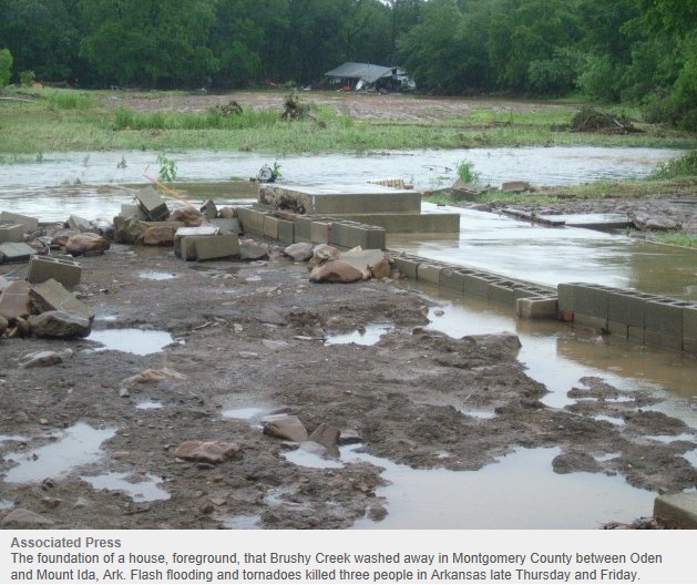
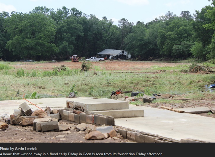
This article was published May 31, 2013 at 1:50 p.m. By Gavin Lesnick
Couple survives in home washed away by flood
video
ODEN — David Lebow's first thought upon awakening early Friday morning to
rapidly rising waters in the creek by his home was to save the lawnmower in the
yard from drifting off.
He didn't know then that a lot more than just his lawnmower was about to be
heading downstream. Lebow, 62, jumped out of bed and found the water already
standing in his home. He got his wife up, tried to collect the family's dogs and
moved to escape. "We got to the front door and ... we couldn't get out — too
much water pressure against it," Lebow recalled Friday afternoon. "We looked at
each other [and said] 'what are we going to do?' And the house went to listing.
Just like one of these big old ships fixing to turn over in the ocean. "And then
it turned around. I told her just hang on. We're going to do whatever. I don't
know what the plan is, but the plan is we're going to do whatever." Lebow and
his wife, Mary Ann, were in the house when it started moving rapidly downstream.
It continued in the floodwaters about 800 feet before the single-story, wooden
structure crashed into a tree and split in two. Only a concrete slab and a few
pieces of debris remained on the lot where it once stood, 1242 Brushy Drive.
Lebow and his wife were in the small section of house. He said they stayed
inside as long as they could before the water got too high, forcing them to get
out and grab hold of a tree. It all happened about 2:15 a.m., Lebow said. He and
his wife were rescued, but not until hours later when the sun came up and crews
could find them. By Friday afternoon, a number of family and friends had
gathered to help salvage possessions from the wrecked home and from along the
path it floated. The floodwaters receded during the day, leaving behind a muddy
mess of pieces of the house and items from the home ranging from a rake to a
dishwasher to a portable generator.
The Lebows didn't have insurance and had lost everything once before 10 years
ago in a fire. It will be hard going forward, Lebow said, but he vowed to
persevere. "It'll be tough recovering from losing everything you've got. But
what can you do? You've got to just keep on trucking. And that's what we'll do.
"Our next plan is to move up on a high, high ridge," he said with a laugh.
"Maybe the tornado won't hit us."
Montgomery Co. Couple Safely Escapes after Storms Rip Home off Foundation
By: Jocelyn Tovar, KARK 4 NEWS Updated: June 3, 2013
Video
MONTGOMERY COUNTY, AR - Six Arkansans lost their lives during the recent weather
events and many others suffered property damage but a couple in Pencil Bluff are
calling what happened to them a story of survival. A couple who lived in a house
near the Brushy Creek River in Montgomery County said they were hit with waters
that resembled a tsunami in recent storms. "This used to be the corner of our
bedroom," said David Lebow who sat on a cinder block wall. The only thing that
remained of what, just a few days ago, was his entire home. This week's storms
made the nearby river rise to dangerous levels and sent rushing water into their
doors. "We got hit by a great big tree and when it did it busted the house in
half," said Lebow. "We couldn't even get the front door open water was coming in
anywhere," he said. Lebow and his wife had no time to think before the waters
knocked their foundation out sending the house floating downstream. "We went to
floating down, way down that way," he said. "That's about 300 yards," said Jack
Vincent who lives next door and says he couldn't believe what he saw. The house
almost three football fields off in the distance. "I have never seen anything
like that before," Vincent said. "All we could see was just water," said Lebow.
"Water here, water there, water there." He said the house only stopped when it
slammed into a tree.
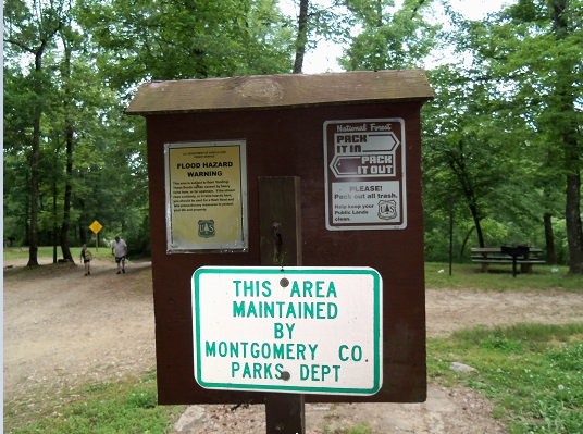
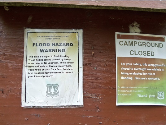
US Forest Service warns of the dangers of flash flooding 11:16 pm, May 13, 2013
Hot Springs, Ark. (KTHV) - With the weather getting warmer and summer vacation a few weeks away, lots of Arkansans are already out enjoying the state's outdoors, but camping can become dangerous if you aren't prepared for what mother nature throws at you. Next month will mark three years since a flash flood tore through the Albert Pike campground near Lake Ouachita. That flood killed 20 people, and the National Forest Service wants to arm campers with the information they need to keep it from happening again. "Flash floods don't really give you a warning. It's just you hear this roaring down, and it's happening," said Terence Peck of the Ouachita & Ozark-St. Francis National Forests. In June of 2010, when a flash flood wiped out the Albert Pike Campground in Montgomery County. The National Oceanic and Atmospheric Administration said flash floods cause more injuries and deaths than any other weather-related incident in the United States. "People ought to be aware of their surroundings and know what flash floods can do," said Peck. "Flash floods bring down rocks, boulders, trees, branches, all kinds of things toward you, and you can get injured more so than just drowning." THV 11 found Rick Hilton in his campsite on Lake Ouachita Monday evening. He admitted that despite the statistics, he worries more about tornadoes than flash floods. The Albert Pike incident three years ago, however, has changed his outlook. "Until the Albert Pike issue, I did not realize the threat that it posed and how rapidly that threat can surface," said Hilton. "When the rain came, the waters came up, and people literally were trapped, they could not get out, and unfortunately, lives were lost... It does make you a little more keen to watch out for things like these." "People come into the National Forest to get away from the concrete, to get away from the buildings from the everyday life" added Peck. "But, they sometimes forget that they're in nature, and they need to be aware of where they're at, and they need to be aware of their surroundings." Peck added that in addition to your tent, sleeping bag and pocket knife, you may want to add your smartphone to your list of essentials when you go out camping. Not only can it help you call for help in the case of an emergency, but you can also check the weather thanks to a number of different websites and weather apps.
The Sentinel-Record June 02, 2013 - 4:44 pm by Mark Gregory
HOT SPRINGS, Arkansas — Entergy Arkansas Inc.'s Hydro Operations was performing
a "balancing act" with Carpenter and Remmel dams on Saturday after heavy rain
prompted a flash flood warning. Entergy activated the "non-failure high water
event" portion of its Emergency Action Plan at 3:12 p.m. Saturday due to the
heavy rain. It was the second time this week that the high-water event
notification had been activated; the first time was Thursday night. According to
the National Weather Service, around 9:10 a.m. Saturday radar indicated "very
heavy rainfall" over the Hot Springs area, in addition to Hot Springs Village,
Lake Ouachita, and Lake Hamilton. One concern was the rising level of Lake
Ouachita, where the pool level was at 582.91 feet above mean sea level at 11
a.m. Saturday. Flood stage is 578 feet msl. The U.S. Army Corps of Engineers has
always considered 585 feet msl to be a key level for some facilities, including
campsites. Certain roadways become inaccessible once Ouachita rises above 585
feet msl. The last time that happened, in May 2011, some campsites and day-use
areas became inaccessible. Lake Ouachita had risen 2.25 feet for the 24-hour
period ending at 11 a.m. Saturday. "It's a big balancing act, trying to consider
all of the stakeholders involved around the lakes and the river, and to mitigate
any negative impacts the best that we can," Bobby N. Pharr, process
superintendent II, Entergy Hydro Operations Support, told The Sentinel-Record
on Saturday. In addition to managing the levels of lakes Hamilton and Catherine,
that "balancing act" includes making sure the banks along the Ouachita River
below Remmel Dam are full prior to opening spillway gates for lake level
control. "When we're not generating, we're not opening gates up, and then all of
a sudden we wait until the storms come and open up gates, it goes from a ...
small amount of flow to a high flow and it undercuts the banks," Pharr said.
Having the banks full "dampens" the erosion effect, and also signals that there
is about to be a release from Remmel. In anticipation of Saturday's rain event,
Entergy had already lowered lakes Hamilton and Catherine to the lower end of
their operating rule curve. The operating rule curve is a band of low and high
levels within which lake levels are maintained. By 11:30 a.m. Saturday, Lake
Hamilton's level was at 399.11 feet above mean sea level and stable. Lake
Catherine was at 304.23 feet msl and "slightly rising but should also shortly
level out," Pharr said. "That's why we lowered the lakes down when we saw
another front was coming, after we got through this first round. We lowered the
lakes to around the bottom of the rule curve," Pharr said. Lowering the lakes in
advance of a rain event helps in two ways, he said. It allows for a slower
release of water from Remmel Dam, dampening the effect downstream, and reduces
the back up of the water coming into the major feeder creeks into the lake, such
as Big Mazarn and Glazypeau."The higher the lakes, the slower that water can get
out of those creeks. That means they back up higher," Pharr said. "Most rain
events are a little bit more gradual than this was," Pharr said. Entergy was
attempting to manage the flow out of Remmel on Saturday to avoid activating the
high-water event notification and shutting off the flow from Blakely Mountain
Dam, which forms Lake Ouachita above Lake Hamilton. Blakely Mountain Dam began
generating again Friday once the flow from Remmel Dam had dropped below 13,000
cubic feet per second of water, ending the first high-water event notification.
By 1 p.m. Saturday, though, Pharr said the inflow into lakes Hamilton and
Catherine was increasing off the creeks, and the Corps of Engineers was asked to
stop generation at Blakely Mountain Dam. Pharr said additional spillway gates
were opened at Remmel Dam to stabilize Lake Catherine's rise. When the
high-water notification was activated Saturday, four spillway gates were open at
Remmel Dam, which was releasing 22,700 cfs, and two gates were open at Carpenter
Dam.
What is a big deal, and I haven’t seen it yet but plan on viewing it tomorrow
when I’m scheduled to go to Ft. Smith, is what the flooding at Y City did. I
don’t know if you are familiar with that area or not but we were told that ALL
the older houses that are on the right side of the road on Hwy 270 just as you
are coming up to the intersection of Hwy 71 are gone. They were washed away.
That would be something that seems impossible to me. Those little old houses
have been there for generations. They were there when I was a child. They say
the only house that remained is a newer brick house that was on down the road a
ways and it would be slightly above the level the others were on. We were also
told that there was about 2’ of water in the truck stop at Y City during the
worst part of the flooding there.
The Montgomery County Road Department worked all through the flooding, including
the weekend, with their big trucks, graders, and backhoes doing repair work on
the county roads that were washed out. A lot of the bridges had the approaches
washed out and those had to be repaired before the road could be reopened to
traffic. There were also several places in the county where the highways were
flooded and they were shut down until the water went down.
I did hear on the scanner that there was a woman stranded in her car on the
Manfred Road bridge across the Caddo River at Caddo Gap. It seems she had seen a
log truck or two cross the flooded bridge and she decided if they can do it so
could she. Needless to say, she didn’t make it. She was rescued before she was
swept off the bridge. The road was then barricaded. I did hear the state trooper
tell the dispatcher that if anyone else wanted to try that to be sure and bring
their towing expense money with them.
Rainfall totals
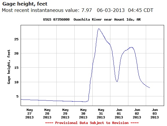
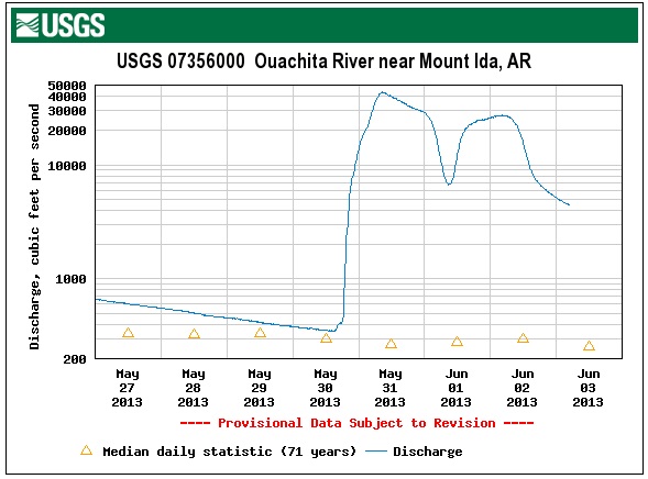
Brushy Creek dumps into the Ouachita River between Oden and Pencil Bluff and has flooded before. The Ouachita drains into Lake Ouachita. In 1929 Blakely Mountain Dam was built as a multi purpose dam to help with flood control. Lake Ouachita Water Level 586.99 feet Monday, June 03, 2013 10:00 am. Level is 8.99 feet above full pool of 578.00. The optimum lake level is 578ft. above sea level. Spillway crest elevation 592 Ft. Level in 1929 0 Ft. Drainage area 414 square miles.
Rain totals from around the area:
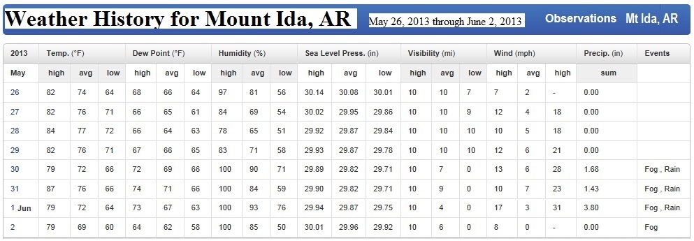
Blakely Dam	 4.11 inches
Mt. Ida 	 7.30 inches since 30 May 2013 Thursday to June 2nd 2013.
Oden 		 9.00 inches since Thursday.
Brushy Road 	11.20 inches
A record rainfall of 3.8 inches was set at Mount Ida 1st June 2013. This breaks the old record of 2.70 set in 1918.
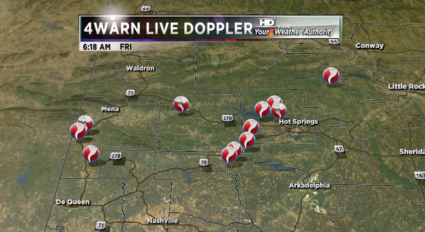
Tornados - June 3, 2013 Arkansas. The National Weather service has confirmed eleven tornadoes across Arkansas confirmed from May 30th and early on the 31st (Thursday afternoon and evening). It’s possible more tornadoes could be added to the list Monday as storm surveys continue.

Tornado #4 – Oden Tornado, EF 2 Montgomery County May 30 2013.
The entire roof was blown off of a house and another house was damaged. A number
of outbuildings were damaged or destroyed. Numerous trees were uprooted or
snapped off.
Estimated peak wind: 120-130 mph
Path length /statute: 3.4 miles
Path width /maximum/: 400 yards
Fatalities: 0
Injuries: 2
Start location: 2.9 SW Oden / Montgomery County
Start lat/lon: 34.6017 / -93.8294
End time: unknown at this time approx 3:15 pm.
End location: 0.6 NE Oden / Montgomery County
End lat/lon: 34.6268 / -93.7786
Tornado #6 – Sugarloaf Tornado, EF 2 Pike County and Hot Spring County. This
tornado began in Pike County moved into Clark County then moved to Montgomery
County and ended in Hot Spring County. A mobile home was overturned and
destroyed injuring 3 people. A large metal barn was badly damaged. The roof of a
house was damaged. Numerous trees were blown down or snapped off; power lines
and poles were blown down.
estimated peak wind: 115-125 mph
path length /statute/: 8.9 miles
path width /maximum/: 300 yards
fatalities: 0
injuries: 3
start location: 1.3 E Rosboro / Pike County /
start lat/lon: 34.2834 / -93.4865
end location: 1.2 NW Bonnerdale / Hot Spring County /
end_lat/lon: 34.3921 / -93.4001
Tornado #7 – Lake Ouachita Waterspout Tornado, EF 1 Garland County This tornado
began as a waterspout in Lake Ouachita. A huge number of trees were blown down
or snapped off. The falling trees damaged a house and a number of cabins. Some
of the cabins had holes poked in their roofs.
estimated peak wind: 100-110 mph
path length /statute/: 3.1 miles
path width /maximum/: 300 yards
end location: 9.2 N Mountain Pine / Garland County /
end_lat/lon: 34.7051 / -93.1761
Tornado #9 – Maumelle Tornado, EF 1 Pulaski County This tornado was on the
ground briefly and was on the north side of a large area of straight-line wind
damage. The tornado blew in the north doors of a metal building and pushed out
the south wall. A mobile home was moved off of its foundation. Numerous trees
were uprooted or snapped.
estimated peak wind: 90-100 mph
path length /statute/: 0.2 miles
path width /maximum/: 50 yards
end_lat/lon: 34.8900 / -92.3898
Ef scale: the Enhanced Fujita scale classifies tornadoes into the following categories.
EF0... weak... ... 65 to 85 mph
EF1... weak... ... 86 to 110 mph
EF2... strong... .111 to 135 mph
EF3... strong... .136 to 165 mph
EF4... violent... 166 to 200mph
EF5... violent... >200mph

Significant damage and at least one injury in Oden, AR. Two homes were destroyed in Oden, about 50 miles west of Hot Springs. The weather service noted, too, that power lines were knocked down and Highway 88 was blocked at one point. Tore roofs off several structures and downed trees. The clouds boiled you had three funnels dropping down, a big one in the middle and then one on each side then all three went together. "It looked liked birds were coming out of the funnel actually it was tin because when it got a little closer you could tell it was large debris "said Doug Carmack who quickly took cover in a cellar with his neighbour. His work shop lost iron. Posted: May 30, 2013 10:54 pm ABC 7 KATV
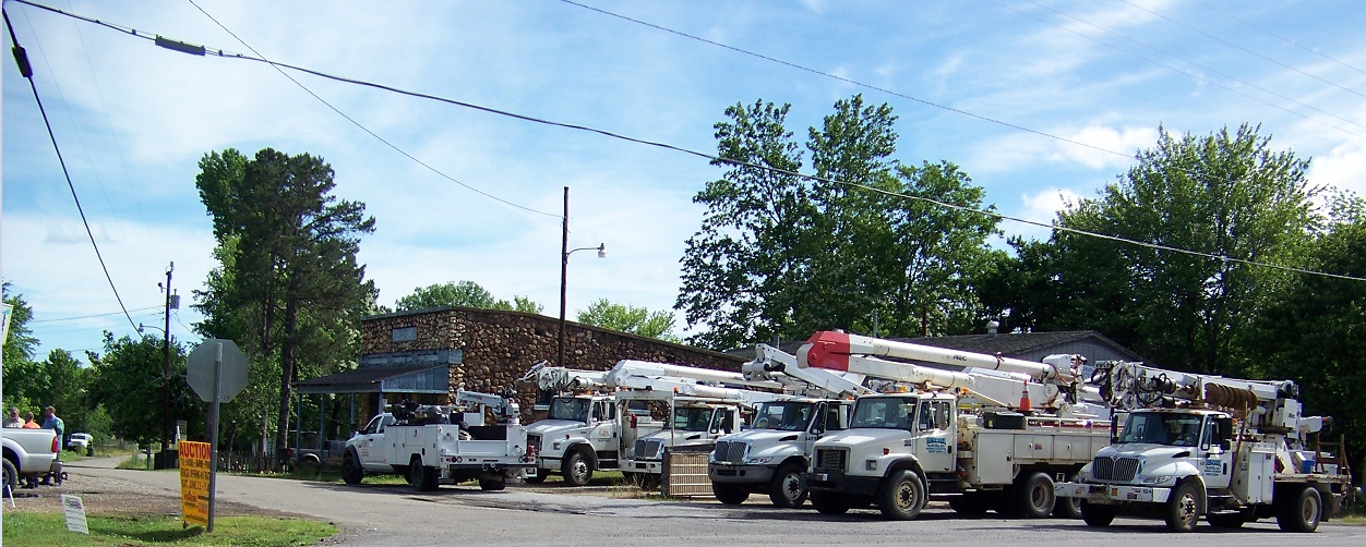
A tornado tears through Montgomery County injuring one person. The tornado touched down in Oden earlier Thursday afternoon tearing roofs off of several structures and downing dozens of trees. Doug Carmack says it was a terrifying sight seeing the tornado heading straight at him. He later came out to see his neighborhood upside down. Mayor of Oden Tim Philbot was shocked to see the destruction left behind. The mayor said they were already considering getting tornado sirens but after Thursday's storms, they are obviously looking at it more seriously and will speed up the process. A 99-year-old woman [90] was injured in the storm but she is doing fine besides being a little shaken up. She is being kept overnight at a nearby hospital and should be released sometime Friday. Her house was destroyed so maybe she will be moved to an assisted living facility. Brushy Rd got telephone land line service back on 3rd June and electricity back on on Saturday 1st June at 8pm. Thanks to all the crews that were out on the weekend in the Oden village, she was a busy little village on Sunday with the crews and church. That parking lock outside the old Oden store probably has never been that busy before. On Sunday Southside road Entergy was trying to repair the lines one damaged and lots of trees down.
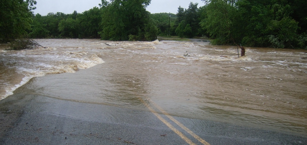
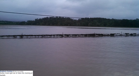
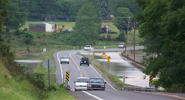
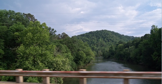
Sunday 26 May 2013 Ouachita River at Rocky Shoals. What a difference a weekend makes. The water was not over the bridge on May 31st 2013 when the area received 11 to 13 inches of rain over a couple of days. Even hay bales floated down the river and cattle were lost.
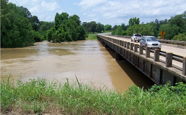
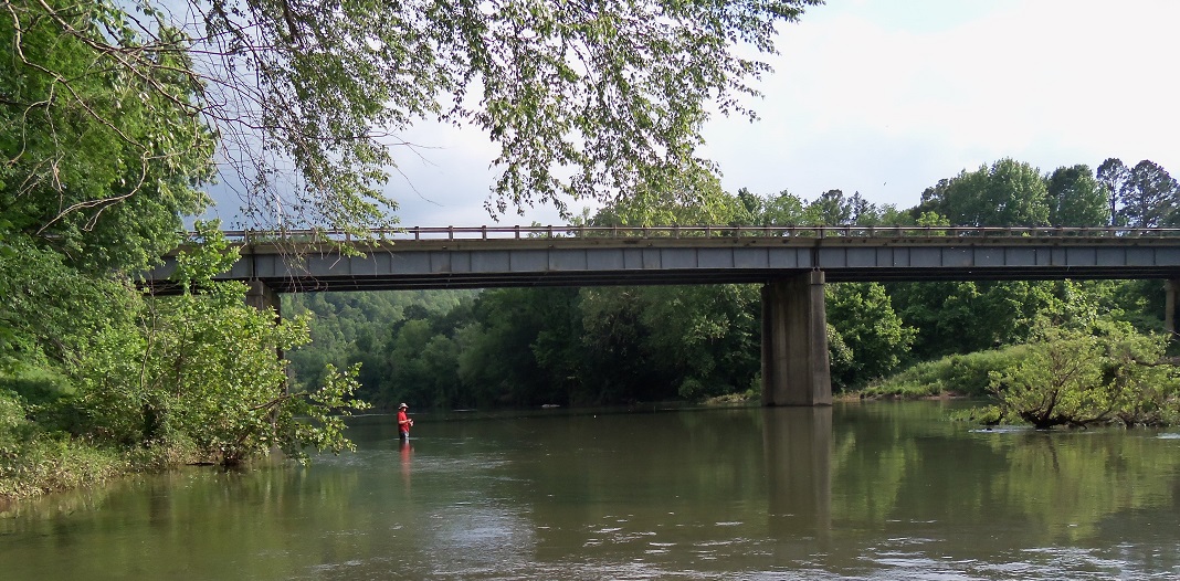
Sunday 26 May 2013 Ouachita River at
Rocky Shoals.