![]()
Montgomery Co. ARGenWeb Project
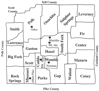
Montgomery County Towns
"We have no title deeds to
house or lands,
Owners and occupants of earlier dates
From graves forgotten stretch their dusty lands,
And hold in mortmain still their old estates"
Over the earlier years the county's civil townships boundaries were changed and divided and subdivided due to increases in population. Understanding the county's formation makes it easier to locate an ancestor on census returns.
1543 DeSoto's expedition
reached as far west as Caddo; a statue in Caddo Gap commemorates the event.
1803 Louisiana Purchase from the French
including Arkansas
1812 Arkansas became part of the Missouri
Territory
1812 Martin and Mary Collier settled around
Caddo Creek
1817 William Tweedle and son John settled
near Caddo Gap
1818 Clark County formed included what was
later to be known as Montgomery Co.
1819 Arkansas designated a territory
1820s Covered wagons used the Old Southwest
Indian Trail (from N.E. Arkansas, through Little Rock, Malvern and Fulton)
1820 First white birth, Jefferson Collier
1829 Montgomery County (Caddo Springs
township) was part of Hot Spring Co.
1832 Old Missouri Trail cut through
Montgomery County just east of what is now Sims
1836 Arkansas became the 25th state
1837 Granville Whittington opens general
store near what is now Mount Ida
1842 Montgomery County formed
from Hot Spring County, Caddo (Caddo Cove), Sulphur Springs and Mountain townships. A post
office established and named Mount Ida
1845 Jan 2.county
line with Yell Co. defined
1845 Courthouse
records remain intact from July 1845 to date
1846 Parks township created
1848 Gap township created
1849 Wagon
train arrived in the Oden area from Tippah Co., MS
1850 Polk - Montgomery counties boundary
changed - the line was moved the width of a township - six miles east. The
original lines ran by Boggy Springs, halfway between Big
Fork and Board Camp.
1850 Population: 1,958
1851 Mazarn created
1856 Big Fork township
created
1859 Feb
2.county line with Polk Co. defined
1860 South Fork created
1860 Population: 3,633 85.5%
increase
1861 Arkansas joined the Confederacy in May
1861 In July
the Montgomery County Hunters, Co. F, 4th AR. Inf.
marched out of Mount Ida with 125 men
1861 Caddo
Rifles formed Co. C, 4th AR. Inf. C.S.A. Approx. 114 men
1862 Company I a part of the 33rd
AR. Inf. Reg., C.S.A. formed at Caddo Gap with 143 men
1870 South Fork, Sulphur Springs, Mountain, Mazarn,
Big Fork, Polk, Gap and Caddo townships made up Montgomery Co.
1870 Population: 2,979
−17.9% decline
1873 Garland Co. formed from Montgomery, Hot
Spring and Saline counties
1873 Part of Mountain
township ceded to Garland Co.
1873 April 24
annexed parts of Montgomery and Clark counties created Valley township, Hot Springs Co.
1874 Dec. 16
county line with Pike Co. defined
1876 Center township
created from part of South Fork
1876 Crystal
created from part of Mountain township
1876 Missouri
created from part of Gap township
1879 Part of Mazarn ceded to Gap
1880 Population: 5,729 92.0%
increase
1880 -1890 Silver boom days
1882 Caney township created
1883 Ouachita township formed
1887 Bear township created
1889 Leverney
township created
1890 Population: 7,923
1894 Smith township created
1897 Cedar Glades township created
1898 Scott township created
1900 Gaston
created from parts of Big Fork, Caddo, and South Fork townships
1900 Population: 9,444 38.3%
increase
1903 Walnut created from Caney township
1905
Missouri-Pacific Railroad reach Womble now Norman
1905 Fir created from parts of Center, South
Fork, and Sulphur Springs townships
1908 Rock Springs townships created from
part of Missouri township
1909 Womble created from
Caddo and Gap townships
1910 Population: 12,455
31.9% increase
1915 Feb
21.county line with Scott Co. defined
1917 Bear, Cedar Glades, Crystal
and remainder of Mountain, part of Leverney annexed to Garland
County. Garland townships that now have previous Montgomery County area include
Baxter, Bear, Buckville (formerly Mountain twp.), Cedar Glades, Crystal, Hale, Mill,
Mountain and Ouachita townships
1920 Population: 11,112
−10.8% decline
1920s School
consolidation began
1920s Caddo
Lumber Company's company town Mauldin established
1930 Population:
10,768
1940 Lumber
industry on the decline
1940
Population: 8,876
1950 Population:
6,680 −24.7% decline
1956 Blakely Mountain Dam dedicated. Lake
Ouachita formed to become the largest lake in Arkansas with a surface area of approx.
40,000 acres extending thirty miles up the valley. Graves were relocated.
1960
Population: 5,295 −19.6% decline
1970 Population: 5,821
8.4%
1980 Population: 7,771 33.5%
1990
Population: 7,841 0.9% increase
1996 Population: 8,448 Average income:
$12,716
2000 Census population: 9,245
17.9% increase. The median income for a household in the county was $28,421, and
the median income for a family was $32,769. Males had a median income of $25,865
versus $18,063 for females.
2010 Population: 9,487 2.6%
increase
Even after 1900, a large portion of the Ouachitas' interior remained in the Public Domain. On December 18, 1907, President Theodore Roosevelt set aside much of this public land as the Arkansas National Forest, which in 1926 was renamed the Ouachita. The Forest Service in its first fifteen years in Arkansas attempted to curb timber-stealing and wildfires, to set up ranger outposts and a telephone communication system. By the 1920's, the Forest Service had built trails and some primitive roads on the National Forest, and was up grading its stands of trees by enforcing rules for selective cutting by lumbermen who bought government timber. During the depression of the 1930s, the Civilian Conservation Corps (CCC) battled woods fires, erected buildings, and constructed all-weather roads on the National Forest. Campgrounds, picnic areas, and swimming lakes were constructed at Shady Lake, Bard Springs, Iron Springs, and Albert Pike recreation areas. Bankrupt farmers and defunct lumber companies sold large acreages of their unwanted land. Cutover timberland was purchased at low prices by the Dierks family, by the International Paper Company, and by the Forest Service. During this decade, the Ouachita National Forest more than doubled in size and expanded its boundaries into Oklahoma. Since World War II, the pattern of land ownership has become more stable. Farmers continue to hold the best agricultural land, private timber companies own the largest part of the better timberland, and the U.S. Forest Service has most of the more rugged backcountry areas (www.fs.fed.us/oonf/maps/history.htm Smith 1988).
References:
Montgomery County: Our Heritage / compiled, edited and published by Montgomery
County Historical Society 1987
Arkansas Township Atlas A History of the Minor Civil Divisions and each Arkansas
County. Arkansas Genealogical
Society P.O. Box 908, Hot Springs, AR 71902-0908 1987 revised edition. Permission was granted from the AGS and Russell Baker, the author, to use details from the
Arkansas Township Atlas. The book is still available by writing to the
AGS. Includes maps of 1930 township boundaries for each county in Arkansas and dates
the townships where created.