Yell County, Arkansas


1895 Map of Yell County, Arkansas, Courtesy of Pam R.


Yell County, named after the second Governor of Arkansas, Archibald Yell, was created on 05 December 1840 from parts of Pope and Scott Counties.

Yell County is, also, nicknamed the "Free State of Yell," due to a district wide election held a number of years back, in which voters cast numerous votes from a candidate from Yell County, that put him over the top. It was then joked that "...Yell County could turn out enough voters to achieve statehood..." [Foster 2]

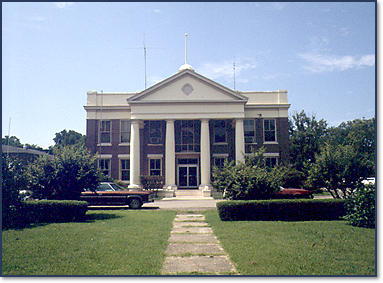
The county seats of Yell County are Danville and Dardanelle. The Dardanelle courthouse (Pictured above--Courtesy of the Arkansas Historic Preservation Program) was built in 1914, designed by architect Frank W. Gibb, and is now on the National Register of Historic Places.


Photograph of the Petit Jean River Valley in Western Yell County from atop Mt. Magazine. In the distance you can see the northern edge of the Ouachita Mountains. Courtesy of John M. Foster, Jr.


Yell County's population was 21,139 in the 2000 US Census, a growth of 3,380 from the 1990 US Census, with Dardanelle being the largest city in the County. The County is comprised of 928 square miles. The main industry in Yell County is the production of poultry, with three processing plants and numerous poultry farms.


image005.jpg

Search this site or the web powered by FreeFind

Site search Web search

image005.jpg

USGenWebA1TM.gifus_arch4.gif


image005.jpg

(c) 2002-2008

County Coordinator: J. Myles Felihkatubbe

State Coordinator: Betsy Mills

Asst. State Coordinator: Jeff Kemp

Site hosted by: ARGenWeb

image005.jpg

This Page Last Modified:

04 September 2008

image005.jpg


closerwalklogo.jpgcloserwalkpaula.jpg

image005.jpg