 |
Columbia County Cemeteries
Cemetery Links:
The Hardy Party - Columbia County Cemeteries
| Anderson Cemetery | - |
| Antioch East Cemetery | East southeast of Magnolia. US 82 to Columbia Rd. 25, turn south, about 1 1/2 miles. The cemetery is across the road from Antioch East Baptist Church. |
| Atlanta Baptist Cemetery | US 82 to State Hwy 98, south abt. 10 miles to Columbia Rd. 85, east on Col. 85 abt. 1/4 mile. Next to Atlanta Baptist Church. |
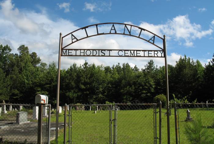
| Atlanta Methodist Cemetery - Photo | From Emerson go East on Columbia Road 98 toward Atlanta. The cemetery would be on the right side of 98 as the road goes North toward Highway 82. |
| Baker Cemetery AKA Baker-Jameson |
Southeast of Magnolia, Arkansas - State Hwy 98 to Col. 32 ( west on Col. 32 ) , abt. 1/2 mile to Col. 298 ( unmarked dirt and gravel road ), to 2nd dirt road on left. At the end of the dirt road, cemetery is abt. 500 yards to the NE, in the woods, on private property. |
| Barlow Cemetery | - |
| Bethel Cemetery | - |
| Bethlehem Cemetery | Take U.S. 82 to State Hwy. 98, south on 98 aprrox. 3 miles, turn east on Columbia Rd. 40, 2 miles to Spotsville. The cemetery is next to Bethlehem Baptist Church, on the north side of the road. |
| Big Hickory Cemetery | East of Magnolia. US Hwy 82 to Columbia 42 , turn north, abt. 1 1/2 miles on the left. |
| Chalybeate Springs Cemetery | Located 9 1/2 miles northeast of Haynesville, La. Take highway Alt. 2 three and 1/2 miles turn north on Wares Chapel Rd. go three and 1/2 miles to Ark. State line then two and 1/2 miles north on county road 14 to Chalybeate Springs Cemetery on right. |
| Christie's Chapel Cemetery | - |
| Cloud Family Cemetery | - |
| Columbia Cemetery | - |
| Crossroads Cemetery | - |
| Dickson Family Cemetery | - |
| Dinktown/Glover Cemetery | - |
| Dockery | - |
| Ebenezer Cemetery | East of Magnolia - US 82 to State Hwy 98 - north about 3 miles on right side of road. Ebenezer Methodist Church , Est. 1849, is on the other side of road. |
| Elliott Cemetery | - |
| Forest Grove Cemetery | - |
| Frazier Cemetery | 2900 Columbia 27 South Magnolia, Ark. |
| Free Hope Cemetery | - |
| Friendship Cemetery | - |
| Gatlin Cemetery | - |
| Glover Cemetery | - |
| Green Cemetery | The road leading to the cemetery is just west of the country store on road #98. You turn right on this road off 98, go a few miles (I think it was about 2) and the cemetery is on the left. It is a very neat cemetery. |
| Harmony Cemetery | - |
| Harris Family Cemetery | - |
| Hartsfield Cemetery | - |
| Hephzibah Baptist Church Cemetery | next to the church located at 22020 Hwy 98, Emerson, Arkansas |
| Jameson Cemetery | near the Lydesdale community. |
| Jerusalem Cemetery | - |
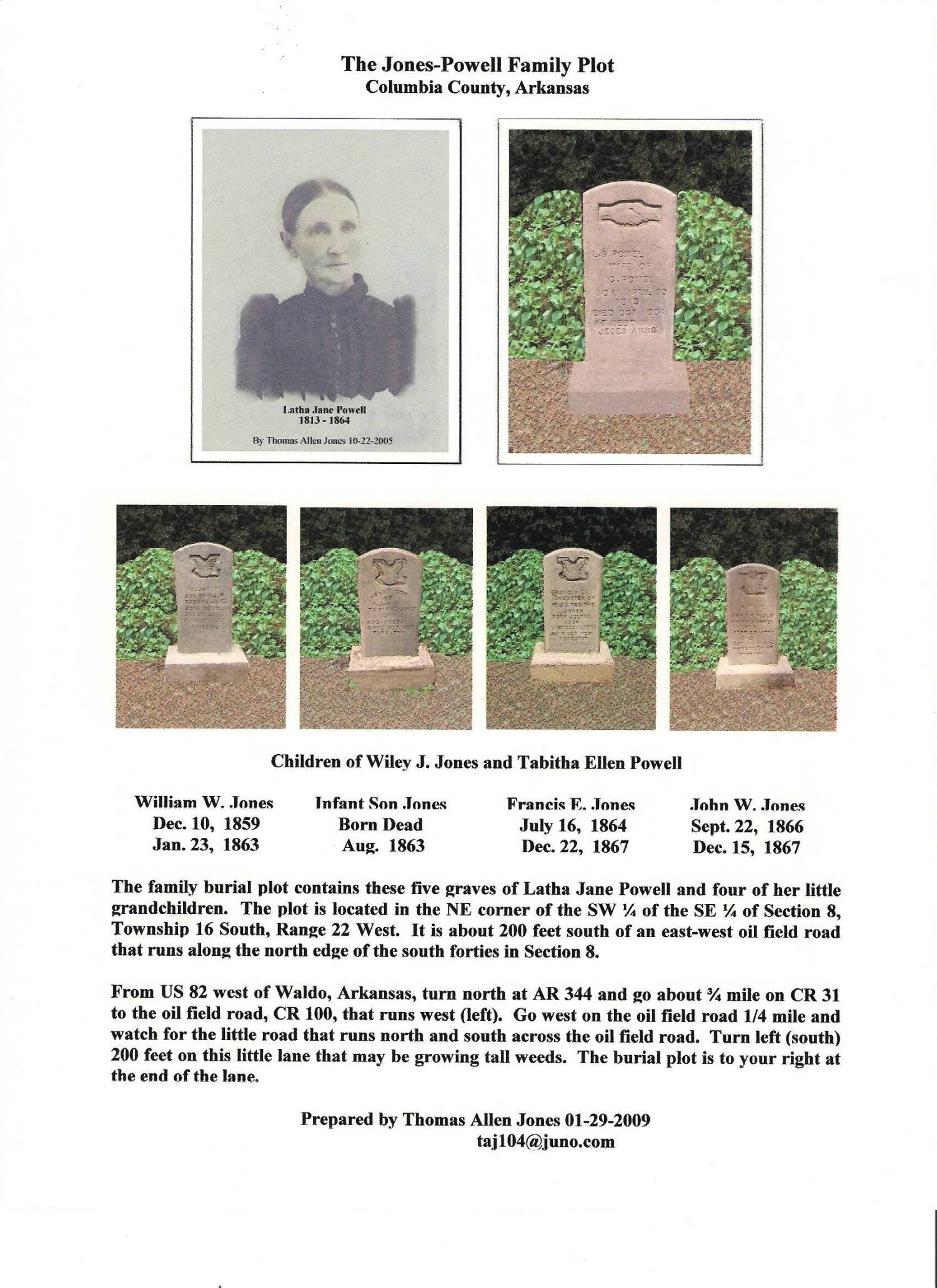
| Jones-Powell Cemetery | Family cemetery - From US 82 west of Waldo, turn north at AR 344 and go about 3/4 mile on CR 31 to the oil field road, CR 100 that runs west (left). Go west on the oil field road 1/4 mile and watch for the little road that runs north and south across the oil field road. Turn left (south) 200 feet on this little lane. The burial plot is on the right at the end of the lane. |
| Kelly Cemetery | - |
| Kings Hill Cemetery | - |
| Lakeside Cemetery | In Stamps, Arakansas, south at Smitty's, left at dead end, cross RR tracks, Past pond, road to right, on left on hill overlooking pond. |
| Macedonia Cemetery | - |
| Macedonia Cemetery | - |
| Magnolia Cemetery | Partial |
| Magnona Memorial Park | Partial |
| McClendon Cemetery | - |
| Memorial Gardens | - |
| Miller
Family Cemetery AKA Old Miller |
From Village, Arkansas: go north on Hwy 98. Turn left on CR38. Turn right on CR440. The cemetery is on the left side of the road. |
| Miner Cemetery | - |
| Mt Pigah Methodist Cemetery | in the Emerson, Ark area |
| New Bethel Cemetery | - |
| New Hope Cemetery | - |
| Old Bethel-Saint John Cemetery | - |
| Old Miller Cemetery | See Miller Family Cemetery |
| Owen Cemetery | - |
| Old Providence Cemetery | Located about three miles southeast of Emerson, AR. From Hwy 79 take Columbia 23 east, cemetery three miles on the right |
| Patterson Cemetery | - |
| Philadelphia Cemetery | About seven miles south from Magnolia, down Burnt Bridge Road |
| Rocky Mount Cemetery | - |
| Rudd Cemetery | - |
| Saint Marks Cemetery | - |
| Saint Matthews Cemetery | - |
| Sardis Cemetery | From Stamps, take Hy 42 to Hope Rd. Turn north on Hope Rd and go about 4 miles. You will see the cemetery on the left across from the church. |
| Scott Cemetery | - |
| Sharman Cemetery | - |
| Shiloh Cemetery | - |
| Spring Branch Cemetery | South of Taylor, AR |
| Stewart-Walkerville Cemetery | - |
| Strong Cemetery | - |
| Traylor Cemetery | - |
| Village Cemetery | East of Magnolia on U.S.Hwy 82 to State Hwy 98; north about 1/2 mile on the right - next to the Village Methodist Church. |
| Waldo Cemetery | - |
| Wares Chapel Cemetery | Located 8 miles northeast of Haynesville, La. Take highway Alt. 2, three and 1/2 miles turn north on Wares Chapel Rd. Go three and 1/2 miles to Ark. State line, then one mile north on county road 14 to Wares Chapel Methodist Church. Cemetery next to Church. |
| Welcome Cemetery | - |
| Western Cemetery | Near Walkerville, Ar |
