![]()

Marion Co TOC
Homepage
Awards
Cemeteries
Census Records
Courthouse Info
Family Genealogies
Heritage Society
Society's Newsletters
History + more
Marion History-book
Maps
Marion Co Timeline
Marriages
Mt Meadow Massacre
Newspapers
Obits
Photo Gallery
Post Office History
Townships
Transcribed Records
Helpful Links
Contact -
Jeana
Graphics by Rhio


BRAMBLE BUSH
THE QUARTERLY NEWSLETTER
OF THE HISTORIC GENEALOGICAL SOCIETY
OF MARION COUNTY ARKANSAS
Vol. 5, No. 2 April 2000 Yellville, Arkansas 72687
BUFFALO RIVER
Compiled by Vicki Roberts
Just west of the Buffalo Fire Tower, deep within the recesses of the Ozark National Forest in Newton County, rises a river whose beginning is indeed insignificant. It bubbles up with uncertainty from beneath a thick mulch of leaves, looks around and trickles a while, suddenly gushes forward to enjoy a quiet spell in a pool of deep clarity, only to gallop forward once more. This river cavorts this way for 148 winding, spitting, spinning miles, snaking and crashing its way through three Arkansas counties of unbelievably wild and lush beauty before joining forces with great White River just below Buffalo City between the boundaries of Marion and Baxter Counties. This river is called The Buffalo.
The origin of this name stems from the once common occurrence of huge herds of American bison in the vicinity of the river. In 1820 bison thrived along the northern and western portions of Arkansas Territory. In 1844 it was stated that bison were abundant over much of the present states of Arkansas and Missouri. Sizable amounts of bison bones have been unearthed in the numerous Native American bluff shelters in the Ozarks, indicating that this beast had long been an inhabitant of northwestern Arkansas.
Human occupation of the Buffalo River Valley began over 10,000 years ago. The oldest inhabitants are known as Paleo-Indians which means Old Indians. These Paleo-Indians used bone, antler, stone, and leather for their tools. Their very existence depended upon hunting and scavenging animals such as the bison for much more than just food.
The Dalton Period began around this time, continuing for approximately 1,000 years, and is well documented in the Ozarks. This period saw climactic changes which introduced the oak, hickory, and elm trees we see today. The most significant diagnostic stone tool from this period is the "biface." It means that not just one, but both sides, or faces, of projectile points and cutting tools were chipped, or worked, by humans. Other stone implements from this period include sandstone mortars, pestles, and grinding stones. These tools suggest an increasing subsistence strategy which processed wild plants for food, medicine, and ornamentation.
As we come down through history, we see the Early to Middle Archaic Period, the Late Archaic and Early Woodland Periods, the Middle and Late Woodland Periods, and the Mississippian Period, all of which are apparent along our Buffalo River. Around 300 years ago the prehistoric inhabitants increased in population and lived in small groups scattered along the major waterways. They continued to use rock shelters for specialized purposes, and established permanent sites on river terraces overlooking fertile bottom lands. There is archeological evidence which suggests greater horticultural substance of maize. A late variant of the Caddoan Culture is represented by shell tempered, undecorated, flat-bottomed ceramic wares. Decorated and effigy ware are rarely found along the Buffalo River.
The Historic Period for the Native Americans in the Ozarks was a time of turbulence. When the French and Spanish explorers arrived, they encountered the Osage Indians. Between 1763 and 1804 the Osage had a number of seasonal hunting settlements between the White and Buffalo Rivers. The Cherokee, in 1817, signed a treaty with the United States which obtaining land between the White and Arkansas Rivers. In 1828 the Western Cherokee signed a new treaty which opened Arkansas Territory for Anglo settlers. Shortly after this the Cherokee were ordered to migrate to the new Indian Territory in what became Oklahoma.
When the first settlers came into Buffalo River country, they were met with wilderness on all sides. They probably marveled at the size and strength of the Buffalo when they settled near her. In places she was as wide as the Mississippi but instead of being muddy, her waters were clear and sparkling.
When, in 1819, Henry Schoolcraft made his famed visit to this part of the country, he noted that people living just north of the Buffalo River Basin lived by hunting and agriculture, although vegetable gardens were unknown. Corn and bear meat provided the primary staples. While corn was grown for bread, for horse feed, and perhaps for the distillation of corn whiskey, it was not considered a cash crop. Schoolcraft saw these early settlers as hardy, brave, independent people, rude in appearance, frank, and generous. They traveled without baggage, could subsist anywhere in the woods, and formed a most efficient military corps in frontier warfare.
The Buffalo, as always, served as the lifeline for the early settlers and life was profoundly affected by her erratic stages. Winters and springs almost always found her in flood stage, sucking everything into her wake, and leaving nothing but clean washed beaches. It took much hard work to rebuild houses, barns, and fences.
The first settlers shared bottom land with Indians until the Cherokee Treaty of 1828 removed the Indians farther west. Local legends contend that a Cherokee village, Sequatchie, was located on the Buffalo in northern Searcy County at the mouth of Spring Creek. This village, traditionally alleged to be the largest town built in Arkansas by the Cherokee, was presided over by Chief Peter Cornstalk who married the daughter of one of the early white settlers, Robert Adams. Sequatchie was supposedly abandoned in 1832 when its inhabitants moved to the new Indian Territory in Oklahoma.
More settlers came. They saw the land was good along the river and burned the cane bottoms and planted crops.
These people who settled on the buffalo were, for the most part, hardworking farmers who wanted nothing more than to clear a few acres, build a log house, and enjoy the peace and tranquillity the valley had to offer.
The settlement of the Buffalo River Basin grew at a steady rate. Determined farmers and hunters entered the region in ever-increasing numbers. A study of the census returns reveals that immigration into Marion, Newton, and Searcy Counties not only kept pace with the rest of the state, but also occasionally surpassed it.
Buffalo River, in 1848 during the Tutt - Everett Feud, is spoken of as the dividing line between Marion County and Searcy County.
As early as 1862, mining in the numerous caves along the Buffalo for potassium nitrate, or salt peter, which was used to make gunpowder, became popular. Operated under the authority of the Confederate Niter and Mining Bureau, which was established in April 1862, the niter works throughout Arkansas produced 17,000 pounds of niter before May of that year. The largest of these works was located on the Upper Buffalo about a mile south of the present town of Boxley.
This operation was made up of 14 permanent buildings, two steam engines, three boilers, a large iron safe, and other assorted mining paraphernalia. Another operation was conducted on Lower Cave Creek in Newton County, and still others along Tomahawk and Big Creeks in Searcy County.
By the end of the Civil War the Buffalo River valley had become a desolate, ravaged, and forlorn area abandoned by many of its inhabitants. Homes had been destroyed, livestock run off or stolen, fields neglected, and six of its able-bodied residents had been killed. Because of the number of marauders, independent companies, and regular units that had operated along the Buffalo during the war I forage was non-existent. The Buffalo River suffered greatly during the war years, but fortunately recovered quickly. From about 1870 a period of expansion and increased population developed, finding its peak a half century later during the mining boom which accompanied World War I.
Giant cedars grew abundantly along the banks of the Buffalo. During the 1870's the most profitable industry along the Buffalo was lumbering. Although sawmills had been common along the river's tributaries since the arrival of the first settlers, production for outside use wasn't begun until after 1870. There was no railroad until 1902 so the river provided the early means of transporting the logs to market. After an extended cutting season which lasted several months, the logs were dumped into the river during flood stage and hastily organized into a sort of raft for the journey downstream to the White. The largest cedar float on record consisted of 175,000 logs and required 22 days to complete.
For a while the cedars that were cut were sent soaring down the river to ultimately go to the penny pencil factories. This brought a flight of good times to the area, and old timers used to recall the back-breaking hard work as well as the happy memories of these cedar floats.
During the zinc and lead mining era in the Buffalo River valley, towns and settlements sprang up all along the waterway.
With the advent of World War I, the demand for zinc revived the North Arkansas Mining District and infused it with sorely needed capital. Records from 1914-1915 illustrate some of the changes to the area. With the prospect of success looming greater than ever, the mining district at Rush in became the site of an immense immigration of prospectors and miners. Practically overnight Rush grew from a sleepy little community of a few hundred inhabitants into a thriving mining camp. Around the mines dotting the mountainsides, miners and their families lived in crudely built cabins and tents. Estimates of the population of the small narrow valley reached as high as six thousand, although it was probably not much more than half of that.
This mining boom along the Buffalo had run its course by 1918. The swift decline of this industry signaled a sudden reversal in the economy of the region. With the main source of employment at a standstill, the miners sought work elsewhere and the local farmers returned to their fields. By 1920 Searcy County had lost 15.9 per cent of its population and Marion County had lost .5 per cent. By 1930 Searcy County had lost almost 25 per cent and Marion, 13 per cent. Life along the Buffalo quickly regained its beauty and tranquillity.
As early as 1880, the men who owned and operated lead and zinc mines began searching for ways to make Buffalo navigable. Transporting the zinc ore was a tortuous trip over roads so rough they jarred the teeth of beast and man. These poor roads - no more than crude tracks - went up mountains and down into hollers to Buffalo City near the junction of the Buffalo and the White. These nightmarish trips compelled the mine owners to try to find a way to use the river to move the ore to market. Many believed the ore could be floated at least six months of the year down the Buffalo on flat barges and then down the White to Batesville. This, however, was not to be.
From the earliest times the Buffalo would not and could not be harnessed nor controlled. Heavy rains regularly sent it into a raging rampage which seriously interrupted any type of transportation. These periodic floods were not to be trifled with. A cloudburst upstream could cause a flash flood downstream in no time. In August 1915, after an exceptional rainfall, the river crested at 54 feet. Again, in December 1982, the Buffalo became an amazing, swollen flood water. On 3 December it crested at 64 feet - higher than any of the few old timers could ever remember seeing it. The Highway 14 bridge, which is 92 feet above the usually placid river, was under water. Huge trees and all sorts of tumbling debris crashed into it or hurtled over it.
No bridges spanned the Buffalo until after 1930. The majority of these were built by men in the Civilian Conservation Corps, a federally operated agency that created jobs during the Great Depression years. Before then crossings were either by wading, by rowing, or by taking the occasional ferry.
After World War II tales of the marvelous fishing and tranquil camping along the Buffalo quickly spread by word of mouth. Float trips were organized and many of the local residents became river guides, all offering their services for profit. Fishermen carried away great tales of the river's merits and charms.
The Buffalo is the nation's first federally protected stream and one of America's great treasures. On 30 January 1967, Senator Fulbright introduced a bill into congress that provided for federal ownership and administration of the Buffalo River. There was, of course, much opposition by the residents and land owners along the Buffalo. Yet, on 7 February 1972 the bill was passed by the House of Representatives and in less than a month President Richard M. Nixon signed Public Law 92-237 "to provide for the establishment of the Buffalo National River. Limited in size to 95,730 acres, the river was now preserved for future generations. Today the Buffalo is under the administration of the National Park Service of the Department of the Interior with offices in nearby Harrison AR.
Today the Buffalo National River is one of the top vacation spots in the United States. Folks numbering over 1,000,000 a year come from all 50 states to enjoy the wild river and its canoeing, camping, fishing, hiking, and backpacking. About 600,000 of these visitors float the Buffalo in canoes and john boats usually provided by concessions at several points near the river.
The land along the 132-mile Buffalo River has thus come full circle. Originally owned by the federal government and offered for sale during the early years of the nineteenth century, it has been returned to its original unbelievably wild and naturally lush beauty, again under the guardianship of the federal government.
Sources: "Indian Affairs, Laws, and Treaties Vol II" Government Printing Office 1904; 1840 US census; "War of the Rebellion, Series I" Arkansas Historical Quarterly XIX 1960; "Cutting and Roating" Lackey; Henry Schoolcraft writings; "Let The River Be" Pitcaithley; "These Hills My Home, a Buffalo River Story" B Touchstone Hardaway.
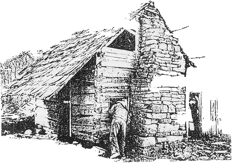 Collier cabin
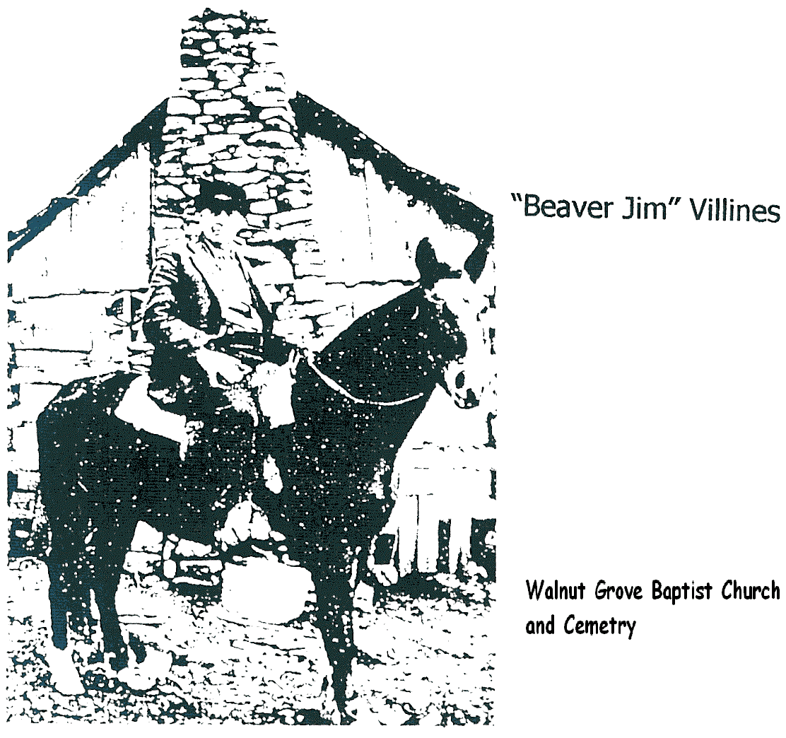 "Beaver Jim" Villines"
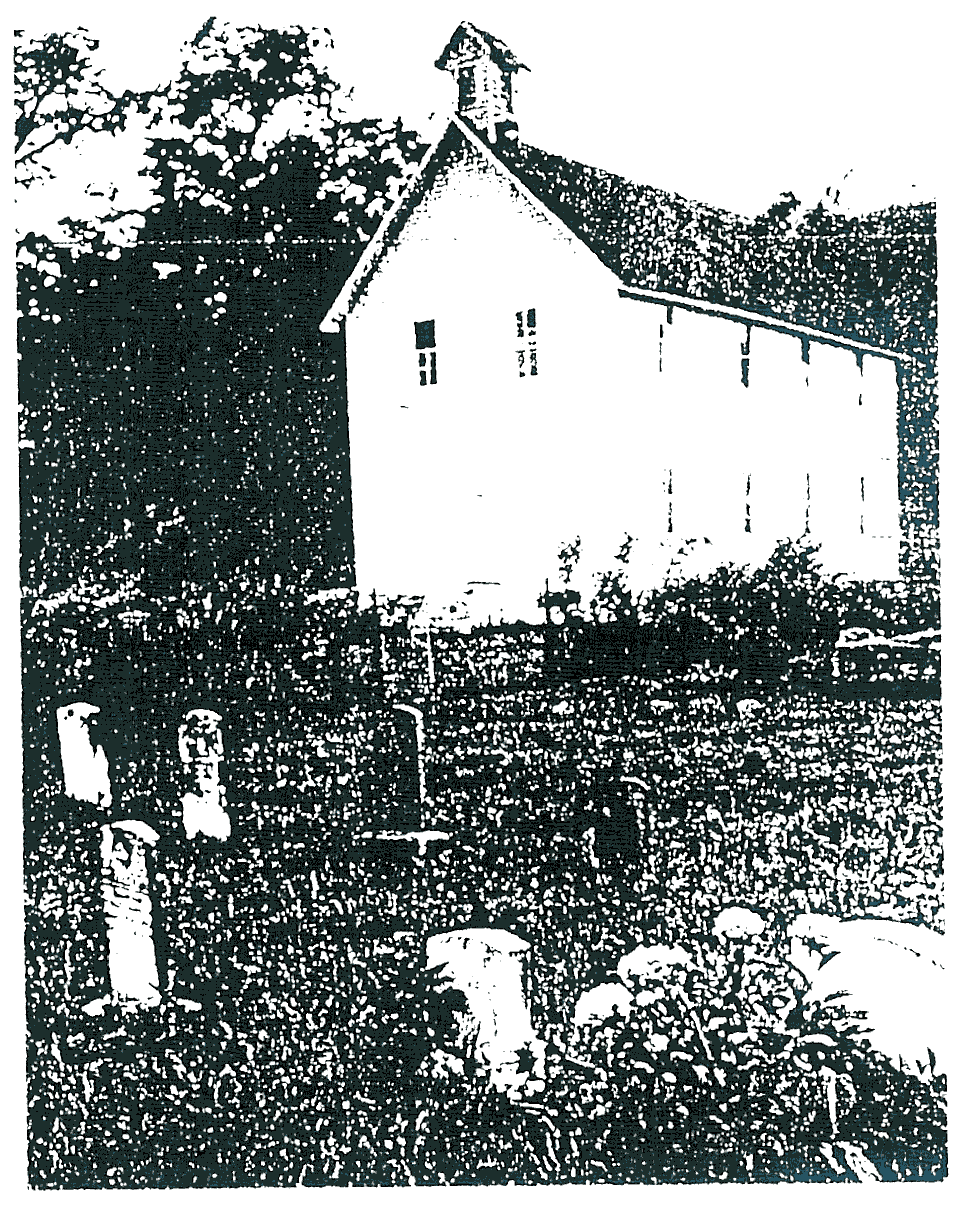 Walnut Grove Church
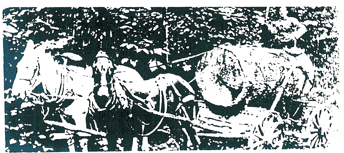 Logging cedar
VILLINES FAMILY
Compiled by Mysty McPherson
| 1 | ABNER VILLINES b VA 1772 m MARTHA___ b VA 1772. One of the early settlers of the Buffalo River. In Van Buren Township, Newton Co. AR 1850. |
| 1 Children of Abner & Martha ( ) Villines | |
| 2 | HEZEKIAH VILLINES b VA ca1895 d Van Buren Township, Newton Co AR 1844 m ELIZABETH __ b NC ca 1800. She is a widow in Van Buren Township 1850. They lived in TN and MO before settling in Newton Co. AR. She paid $50 on 24 October 1851 for 40 acres of land in Section 35 T16W R 23N (Cert. No. 5468). |
| 3 |
NATHANIEL VILLINES b NC ca 1816 m ALLA H. __ b AL ca 1822. Immigrated to Van Buren Township, Newton Co AR 1843, settling near Buffalo River. David F. Villines b TX ca 1834 and Mary L. Villines b TX ca 1838 are living with them in Van Buren Township, Newton Co. AR in 1850. |
| 4 |
HOSEA VILLINES b NC ca 1829 m LUCINDA - b TN ca 1829. He paid $50 on 29 Dec 1851 for 40 acres in Section 36 T16N R23W (Cert. No. 5647). In Van Buren Township, Newton Co. AR 1850. |
| 5 | COPELAND VILLINES b NC ca 1824 m JINCY REEVES b IN ca 1827. In Van Buren Township, Newton Co. AR 1850. Paid $50 on 30 May 1859 for 40 acres in Section 36 T16N R23W (Cert. No. 11387). In Van Buren Co. AR 1860. |
| 6 | ADDISON "Add" VILLINES b NC ca 1827 m LUCY __ b TN ca 1830. Emigrated to Van Buren Township, Newton Co. AR 1848, settling near Buffalo River. In Van Buren Township, Newton Co. AR 1850. Add's Creek, which runs into the Buffalo River near the Ponca Bridge, was named for him. The land on which the town of Ponca now stands originally belonged to "Add" Villines. |
| 7 | WILLIAM VILLINES b NC ca 1828 d Newton Co AR 1875, an invalid for several years, bu Beechwood Cemetery, Newton Co. AR m REBECCA CECIL (daughter of Joseph & Margaret [Penn] Cecil) b TN ca 1834. Served in Co. C, 1st AR Regiment USA, discharged 20 May 1865 for disability. |
| 2 Children of Hezekiah & Elizabeth ( ) Villines | |
| 8 | NANCY VILLENES b NC ca 1830. |
| 9 | JASPER VILLINES b TN ca 1832. |
| 10 | JOEL K. VILLINES b MO ca 1834. |
| 11 | ROBERT VILLINES b MO ca 1838. He was the miller at the Samuel Whiteley grist mill at Boxley. |
| 12 | FRANCIS VILLINES b MO ca 1839. |
| 3 Children of Nathaniel & Alia H. ( ) Villines | |
| 13 | ABNER VILLINES b AL ca 1841. |
| 14 | EZRA VILLINES bAR ca 1843. |
| 15 | JOHN W. VILLINES b TX ca 1846 |
| 4 Children of Hosea & Lucinda ( ) Villines | |
| 16 | MARGARET E. VILLINES b Newton Co. AR ca 1847 m WILLIAM ROARK. |
| 17 | JOSEPH VILLINES b Newton Co. AR ca 1848. |
| 5 Children of Copeland & Jincy (Reeves) Villines | |
| 18 | WILLIAM VILLINES b Newton Co. AR 4 April 1843 d Newton Co. AR 3 Jan 1917 bu Low Gap Cemetery. Served in Co. C, 1st AR Regiment USA. |
| 19 | MARY G. VILLINES b Newton Co. AR ca 1845. |
| 20 | NANCY VILLINES b Newton Co. AR ca 1847. |
| 21 | MARTHA VILLINES b Newton Co. AR ca 1848. |
| 6 Children of Addison "Add" & Lucy ( ) Villines | |
| 22 | ELIZABETH VILUNES b Newton Co. AR ca 1848. |
| 23 | HEZEKIAH VILUNES b Newton Co. AR ca 1849. Homesteaded land in 1873 in Section 22 T16N R23W. |
| 7 Children of William & Rebecca (Cecil) Villines | |
| 24 | NANCY VILLINES b 2 Sep 1852 d 2 Sep 1989 mil JOHN BLACK; m/2 JOHN HENSON. |
| 25 | JAMES A. "Beaver Jim" VILLINES b 30 Nov 1854 d Newton Co. AR 23 July 1948 m SARAH ARBAUGH (daughter of Coonrad & Elizabeth (__) Arbaugh) d Newton Co. AR 1932. Renowned beaver trapper. |
| 26 | MARGARET E. VILLINES b Newton Co. AR 1859 m HORACE ARRINGTON. |
| 27 | FRANCIS MARION VILLINES b Newton Co AR 11 Feb 1861 d 31 May 1908 m EVELYN EVANS. |
| 28 | GEORGE VILUNES b Newton Co. AR 2 Oct 1867 d 8 Sep 1901 m HARRIET MOORE. |
| SOURCES: "History of Newton County, Arkansas" by Walter F. Lackey; Newton Co. AR web page http://www.rootsweb.com/Namewton |
BUFFALO RIVER VALLEY HISTORIC SITES
Uppler River
James A. "Beaver Jim" Villines was locally renowned for his ability at trapping beaver. His boyhood home is located at the intersection of Hwys 43 and 74. Although at a quick glance this structure looks like a barn, its center is a pre-Civil War log house. "Beaver Jim" was born here in 1854. The log renovation illustrates the Buffalo River settlers' efficient reuse of old structures.
The nearby Beaver Jim Villines Farm, "Beaver Jim's" second home, is located at the Ponca River Access and is reached by a short hiking path. Jim purchased this farm and moved across the Buffalo shortly after his marriage. The double pen log house and log out-buildings, built about 1880, are typical of the nineteenth century Buffalo River farm.
Six miles off Hwy 7 on the Erbie Access Road and just beyond Erbie Campground is one of the earliest historical sites on the Buffalo River. The finely crafted, one-and-a-half story log house, built about 1840, was used as a family home until 1977. The house layout is reflective of the North Carolina heritage of the Parker Family. This is known as the Parker - Hickman Farmstead.
The Erbie Community is stretched both north and south of the Buffalo River. The Erbie Church, built around 1900, marks
the town site center. The Jim Farmer Farm is located in this area as well as the Cherry Grover Cemetery.
On the Calf Creek Road near Tyler Bend is a rough road which parallels the Buffalo. It can be accessed by high clearance vehicles or by hiking. This road crosses Arnold Bend and Cash Bend, passing an old school house, early homesites, cemeteries, and the "tie slide" from the early logging days.
The Rush Heritage District located 6 miles off Hwy 14 is the site where zinc ore was discovered in the early 1880's which became the impetus for a mining boom period along the Buffalo River. Remains of several residences and mining facilities still stand at Rush, including the 1886 smelter built to extract the silver that was thought to be present.
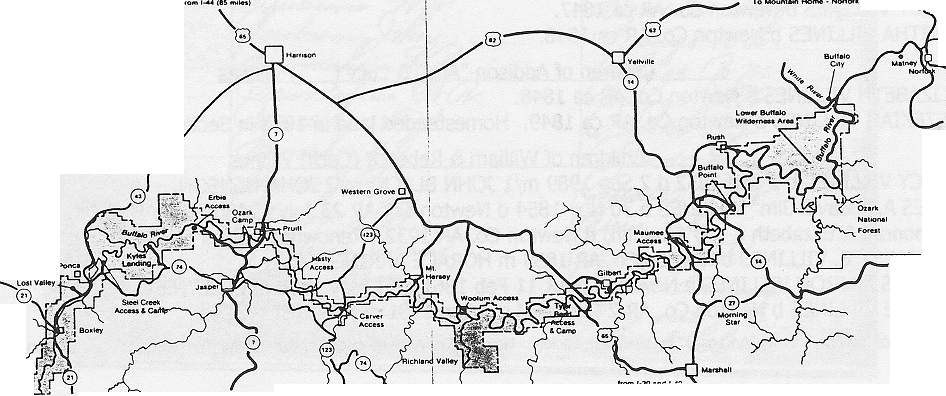
Buffalo River Map
MARION COUNTY VOTERS' LIST 1893
Included here is more of the 1893 County Voters' Lists. This list is now on-line at the Marion Co Site
ELEVENTH NORTH ARKANSAS ANCESTOR FAIR
The Eleventh North Arkansas Ancestor Fair will be held 1-3 June 2000 in Leslie and Marshall AR for all researchers and county historical societies in North Arkansas. This has been a popular event for north Arkansas researchers of both history and genealogy. It has been call a "genealogical swap meet" and "a place to brag on your ancestors." The Ancestor Fair is a place to meet north Arkansas kinfolk and learn about the past.
Thursday and Friday program topics will be "Civil War Peace Society in North Arkansas," "Non-traditional Research in Missouri," Civil War Refugees in the Ozarks," "The Life and Times of Silas Claiborne Turnbo [19th century recorder of Ozarks' history]." "Genealogy on the Internet," and "Computer Genealogy: Comparing Software." Program presenters will be Lynn Morrow, Missouri State Archives; John Bradbury, Western Historical Manuscripts Collection, University of Missouri-Rolla; James J. Johnston, Searcy County Historical Society; Tracey Converse, sponsor of the Arkansas Family History Association website.
Saturday, 3 June, Dorothy Tincup Mauldin, popular speaker and researcher, will discuss "Researching the Five Civilized Tribes" (Cherokee, Choctaw, Creek, Chickasaw, and Seminole).
Saturday will be devoted to information exchange and book and resource sales. Family and county historians occupy tables and share information at no cost. Small publishers, book dealers, photograph restorers, county historical societies have their wares for sale.
Admission to Saturday's Ancestor Fair and its resources is free. Table space for information providers is free. There is, however, a fee for the programs and for Friday night's Mixer-Dinner.
For more information contact James J. Johnston, 2333 N. East Oaks Drive, Fayetteville AR 72703. Phone 501-442-3691. e-mail <johnston@ipa.net>
SO
YOU'RE SCOTTISH

Text: Resolution 155 105th Congress, 20 Mar 1998.
MARION CO. BUFFALO RIVER POST OFFICES
Buffalo City. Established 5 January 1848, E. B. Tunstall, postmaster. Closed 1855. Reestablished 1884 as Toney, Lorenzo D. Toney, postmaster. Renamed Buffalo City 1893. Moved to Baxter Co. AR 4 June 1923.
Dugger. Established 1907, M. E. Taylor, postmaster. Vicinity of Rush. Closed 1918.
Hepsey. Established 1981, Erasmus E, Adams, postmaster. At Adam's Mill. Closed 1926.
Keystone. Established 1904. J. R. White may have been postmaster. At Silver Hollow. Closed 1911.
Maryhattiana. Established 1899, W. A. Wilbur, postmaster. At the mine of the same name in the Rush area. Closed 1902. Named for mine owner's three daughters - Mary, Hattie, and Anna.
Rush. Established 1886, Jesse E. White, postmaster. Closed 1888. Reestablished 1888 as Exter. Renamed Rush Creek 1890. Closed 1954.
Salgado. Established 1900, Fred Sanders, postmaster. Closed 1911.
Silver Run. Established 1897, John W. Massengale, postmaster. Moved to Mull 1916. Closed 1917.
Sylva. Established 1883, Nicholas R. Sagarus, postmaster. Closed 1911.
BITS AND PIECES
In 1834, the well-known Methodist Episcopal preacher Lorenzo Dow made this reference as part of a diatribe against preachers who "make the Bible clash and contradict itself by preaching. . . .
You can and you can't,
You shall and you shan't,
You will and you won't,
And you will be damned if you do
And damned if you don't."
Patents for Inventions Issued by the United States Patent Office:
J. M. Collins of Marion Co. AR for a cylinder & trough gold-washer issued 14 May 1850 Patent No. 7361.
A. S. Layton of Yellville for a bee hive issued 9 Feb 1869 Patent No. 86,765.
Arkansas Family Historian Vol. 28 No.2 page 96.
FAMILIES & FAIRS
Families & Fairs is designed to announce dates and places of reunions, ancestor fairs, and historical commemorations wherever they may be held. The information must reach us no later than March 15, June 15, September 15, and/or December 15 to be included in the next issue of Bramble Bush. The name and address of a contact person must be included. This feature is free of charge.
CAGLE /LEE. The Cagle/ Lee Family Reunion will be held 27 May 2000 at Point 125, Peel AR. For information contact <gstice@mtnhome.com> .
PAYNE. The Payne Family Reunion, descendants of John Thomas & Mary (Herron) Payne, will be held at the Ramada Inn, Mountain Home, Baxter Co. Arkansas on Saturday, 1 July 2000. For information contact Dean and Sandy Payne, MC 4007, Pyatt AR 72672. (870)-427-3319. <spayne@pyatt.net>
SIMMONS. The Simmons Family Reunion, descendants of James Bailey Simmons, will be held 18 June 2000 at Tulsa OK. For information contact <Ijk@webzone.net>.
ELEVENTH ANNUAL NORTH ARKANSAS ANCESTOR FAIR. 1-3 June 2000 at Leslie AR. For information contact James J. Johnston, 2333 N East Oaks Drive, Fayetteville AR 72703 phone 501-442-3691 e-mail johnston@ipa.net.
HGSMCA MEMBERSHIP
Membership in the Historical Genealogical Society of Marion County Arkansas is $12 per year.
Membership for one year runs from 1 January to 31 December of that year.
Membership includes the quarterly newsletter Bramble Bush.
Membership begun later in the year includes all issues of Bramble Bush for that year.
Make your check for $12 payable to HGSMCA and send to HGSMCA, PO Box 761, Yellville AR 72687-9612.
![]()
![]()
Return to Bramble Bush Index Page
Return to Marion Co Home Page