Map. Grapevine Mtn 2,123ft. Highest peaks in Montgomery County, AR.
Map. Grapevine Mtn 2,123ft.
Highest peaks in Montgomery
County, AR.
Learn where an individual lived and when he lived there!
After you obtain the legal description of the land, do a search, at the BLM web site, leaving off all names, just the legal description. This will tell you who the neighbors of the person you are researching would have been in the same section.
Arkansas
General
Land Office Records to 1908 search. After 30 June, 1908 the General Land Office
commenced a new record keeping program.
Federal Land Records of
Arkansas
Arkansas Land Records
Montgomery County Assessor's Office
map - has
elevation, measurement, layers
The Freedmen's Bureau Online The
Bureau of Refugees, Freedmen, and Abandoned Lands, often referred to as the
Freedmen"s Bureau, was established in the War Department. The Bureau supervised
all relief and educational activities relating to refugees and freedmen,
including issuing rations, clothing and medicine. The Bureau also assumed
custody of confiscated lands or property in the former Confederate States,
border states, District of Columbia, and Indian Territory.
Atlas of Historical
County Boundaries
Geonames for the US Geographic Names Information System (GNIS)
Sanborn Maps
Bureau of Land Management,
Eastern States, the Official Land Patent Site and for land laws. Land
patents (a first title deed), often called grants, are documents issued under various land
title transfer authorizes and acts of Congress to people who were considered the original
owners of the land in federal land states west of the Appalachian mountains and this
includes Arkansas. The BLM site allows a search of the land patentee database by
name or by land description. It is possible to search names of all
patentees in an area. The patents have been digitally imaged and are available for
viewing. You may also download a copy of the act of Congress, which authorized the
program for the issuance of a particular patent. Check spelling variations. Note the
patent number! Who held the first patent in Montgomery Co. AR?
An individual was given a copy of the patent. Any patent certificates out there?
Land entry case files and applications of those who settled in Arkansas after the Homestead Act of 1862 are in the National Archives Order (NATF Form 84) inquire@arch2.nara.gov [Land Entry Papers - for Federal lands only]. Pricey fee charged - $17.75 as of April 2000). Arranged by the legal descriptions of the land (state, land office, type of transaction, then case number). The applications will sometimes have more information and a signature. There will be very little data for cash entries maybe one additional page.
Desmond W. Allen published Arkansas Land Patents Through (30 June)1908 (Conway, Ark.: Arkansas Research, 1990), a fifty-seven-volume series with information taken from the BLM database described above. e.g.:
WILLIAMS, AMANDA E.: Vol. AR3200.170, Land Office. Camden, 15-OCT-06, Doc#13205, Misc. Doc#24430, Homestead Original, Formerly Amanda Wacaster - Widow of Andrew Wascaster;
Part # 1 NWNW, Sec. 26, Twp.3S,R23W
Part# 2; NWNW Sec. 27, Twp.3S,R23W
Part# 3; S NE Sec. 27, Twp.3S,R23W160. 000 acres
What are land patents?
All of what is now Arkansas was once owned by the federal government--it is a public domain land state. People who purchased land from the federal government received documents called land patents. Land was obtained through purchase, military warrants, homesteads, scrip acts and other laws that allowed the land to be transferred out of federal hands. Land entry case files are most apt to have helpful details about families or clues that help piece together information from other sources.
Acts of Congress Authorizing the Land Patents
June   4 1897: 	Forest Lieu Selection-Non 	(30 Stat. 11)
May   20 1862: 	Homestead Entry Original 	(12 Stat. 392)
March  3 1855: 	Scrip Warrant Act of 1855 	(10 Stat. 701)
July  22 1854: 	Private Land Claim 		(10 Stat. 306)
Sept. 28 1850: 	Scrip Warrant Act of 1850 	(9 Stat. 520)
April 24 1820: 	Sale-Cash Entry 		(3 Stat. 566)
The land patent will give little other than the name and where the exact location of the land and with a general highways or ONF map with the sections you can plot out where the land was located.
Counts for parcels of land by the decade in which the corresponding land patents were issued: 1840s 62
1850s 178
1860s 1281870s 130
1880s 752
1890s 8461900s 1656
1910s 1659
1920s 394
How did homesteaders describe their land claim? 4 parts: the Meridian, Township, Range and section number
"The Homestead Act 1862 which became law on Jan. 1, 1863, allowed anyone to file for a quarter-section of public domain land (160 acres). The land was yours at the end of five years if you (were a citizen or intended to be one), had reached the age of 21, had built a house on it at least ten by twelve feet in size with at least one glass window, dug a well, broken (plowed) 10 acres, fenced a specified amount, and actually lived there (he could not abandon it for more than six months at any time) and paid certain fees (proving-up). The homesteader had to apply for a patent for a $15 filing fee" About 60% of those who applied for the homestead land never completed the requirements to receive a patent to the land. Description of the Section, Township, and Range surveying system Later, families built larger homes and the log cabins were often converted into sheds or barns.
Cash Entry
With as little of six months residence and improvement, the homesteader could purchase the land by commuting his homestead entry to a cash entry. The price was usually $1.25 an acre. The aim of the Homestead Act was to promote land ownership by small land owners, tillers of the soil. The provision for quick purchase tended to nullify this aim and made it possible to purchase large land holdings.
Proved Up
The land became taxable when the homesteader proved up (paid certain fees) but he could delay this event for two years. If he died before proving up the family inherited his rights to the land. He could not relinquish the land to any but the government until he had proved up. Only citizens of the United States could prove up.
Confederate Veterans
From Jan. 2, 1867 Confederate Veterans could take homesteads by making the affidavit that they would bear true allegiance to the government of the United States. After 1872, soldiers, sailors and marines who has served 90 days during the Civil War were allowed six months after locating claims to establish settlement there on. Their military service, up to four years, could be deducted from the five years of required residence and they could make homestead entry by agent as well as in person. In 1891 the law specified a residence of 14 months for commutation.
Sixteenth Section School Lands
The section of land known as the sixteenth section in every survey township in the state of Arkansas was set apart to benefit schools. The monies received were used to support public schools. This land good be leased. Under the provisions of an Act of the General Assembly of the State of Arkansas, entitled "An Act regulating the sale of the Sixteenth Sections, and to provide for the collection of all claims due the School Fund arising from the sale of the said Sixteenth Sections and for other purposes" approved March 31 1885; Act 231 conveyed the title to all sixteenth section school lands which were the property of the State of Arkansas to the school districts where the lands are located and authorizes the districts to sell the lands and use the proceeds for school purposes. Through the years the county school commissioners sold that sixteenth section land to build school houses and pay teachers. School Lands Index. Land Records
Yes, you can find the section!
 William W.
MAULDIN homesteaded 160 acres 15 October, 1906. NW 9 2S 25W [North west quarter
of section nine in township two south of range twenty-five west of the fifth principal
meridian] That will be the northwest quarter of section nine on the Gaston map to
the right of Mimosa.
William W.
MAULDIN homesteaded 160 acres 15 October, 1906. NW 9 2S 25W [North west quarter
of section nine in township two south of range twenty-five west of the fifth principal
meridian] That will be the northwest quarter of section nine on the Gaston map to
the right of Mimosa.
Land between the invisible latitude and longitude lines was divided into townships. A township line ran east to west. Six mile intervals north and south of a base line. A range line ran north to south is also at six mile intervals and is determined by east or west measurements from a principal meridian. Arkansas only has the Fifth Principle Meridian which runs north from the confluence of the Arkansas and Mississippi Rivers. Arkansas is divided into two parts (north and south) by the base line which runs through Montgomery County and on through southern Pulaski County. Each township is a square six miles in each direction. A township was divided into thirty-six sections. Each section was one mile each direction - that's 640 acres, each section divided into quarter sections of 160 acres each. Township and range lines are normally adjusted every 4th line to correct for the spherical nature of the earth. Homesteaders would check with the Land Office and go out and locate and mark the corners e.g. with posts or a witness tree, a tree that had been blazed with an axe, and file the papers (an affidavit that the land was his or her exclusive use and benefit) so no one else could claim the property.
Mt Ida is located at T2S, R25W sec24 Range line
North
Baseline
SouthT1N
R27WT1N
R26WT1N
R25WT1N
R24WT1N
R23WT1N
R22WT1s
R27WT1s
R26WT1s
R25WT1s
R24WT1s
R23WT1s
R22WT2s
R27WT2s
R26WT2s
R25WT2s
R24WT2s
R23WT2s
R22WTownship
lineT3s
R27WT3s
R26WT3s
R25WT3s
R24WT3s
R23WT3s
R22WT4s
R27WT4s
R26WT4s
R25WT4s
R24WT4s
R23WT4s
R22W
A township, 6 miles x 6 miles, is divided in 36 sections 6 5 4 3 2 1
7 8 9 10 11 12 18 17 16 15
14 13 19 20 21 22
23 24 30 29 28 27 26 25 31 32 33 34 35 36
One township = 36 sections or 36 sq. miles =144 quarter sections = 23,040 acres
Indirect and Direct Index
 Land patents
involved transfer of land out of the public domain. Future transfers are recorded in the
county courthouse deed books and list the name of the purchaser (grantee or
indirect) and the seller (grantor or direct) also lists the legal description of the land
and the price paid. The Montgomery County books are labeled Indirect (Grantee) and Direct
(Grantor) Index. From these indexes, the person searching the record will find a deed or
mortgage book and page number where the copy of the deed or mortgage is actually located
as of record. Mortgages are indexed as to the mortgage, and the mortgagor, the person who
mortgaged the property. A Warranty Deed, the most common deed, is whereby someone
sells absolutely and outright his property to another individual.
Land patents
involved transfer of land out of the public domain. Future transfers are recorded in the
county courthouse deed books and list the name of the purchaser (grantee or
indirect) and the seller (grantor or direct) also lists the legal description of the land
and the price paid. The Montgomery County books are labeled Indirect (Grantee) and Direct
(Grantor) Index. From these indexes, the person searching the record will find a deed or
mortgage book and page number where the copy of the deed or mortgage is actually located
as of record. Mortgages are indexed as to the mortgage, and the mortgagor, the person who
mortgaged the property. A Warranty Deed, the most common deed, is whereby someone
sells absolutely and outright his property to another individual.
Tract Books: Official recorded the individual's name and location of the land in tract books and on plat maps. Arranged by sections within townships. As each piece of land was sold the purchaser's name was entered on the page with the legal description of the land that corresponded to the parcel of land purchased.
Township Plats: Plat books are maps of lots within the tract (township). After many years of being written on and over, the plots are often rather illegible and the tract books are a better finding tool for the legal description. There is an 1840s Plat Book B at the Montgomery Co. Courthouse in Mt Ida in the little brown metal safe on the wall to the right as you enter the vault.
Plats of Towns 1855-1929, 1855-1872 in County Court Record., entry 3; 1873-1929 and 1860-72 in Deed, Record entry 6. Recorded copies of plats of towns in entry 25.
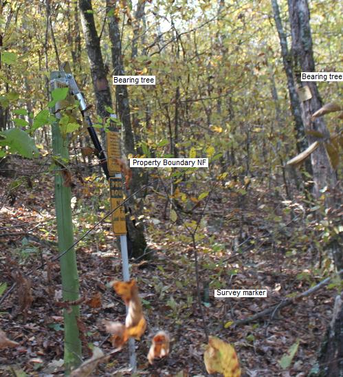
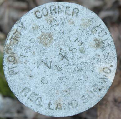
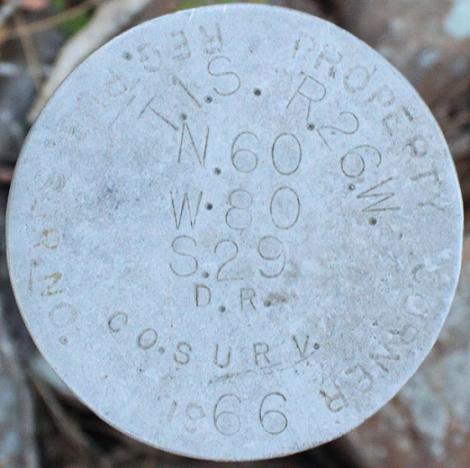
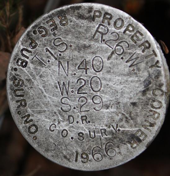
 Resurveying: Most of the forest lands in Arkansas and Oklahoma were
required in the early 1900s before either State began to license land
surveyors. Occasionally old property corners and boundary lines are found to
be mis-located or obliterated enough to make a re-survey necessary so build
structures away from the boundary line to avoid structure relocating and
tree hazard from adjoining NF land. The resurvey record is coordinated with the original
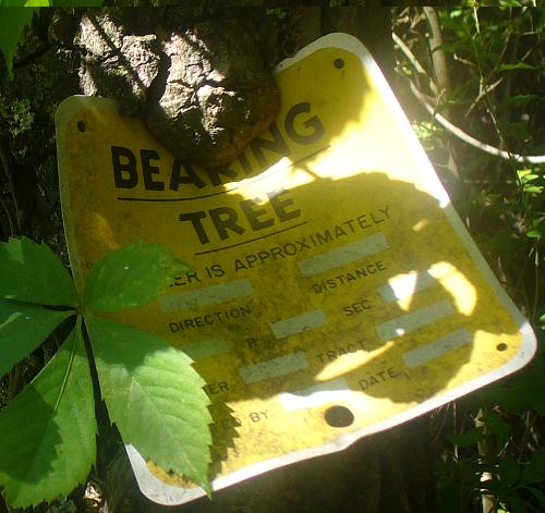
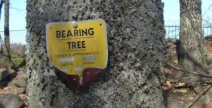
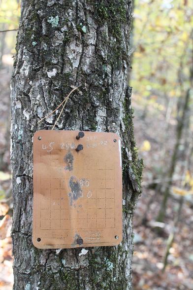
record. Surveyors were
required to blaze each bearing tree with the number of the tier, range, and
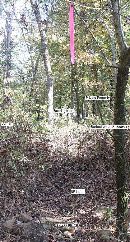
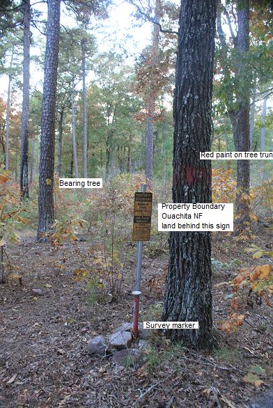
section in which it stood. BT: A bearing tree is a marked tree used as a
corner accessory; its distance and direction from the corner being recorded.
Bearing trees are identified by prescribed marks cut into their trunks; the
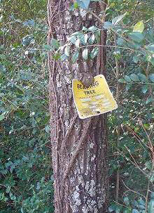
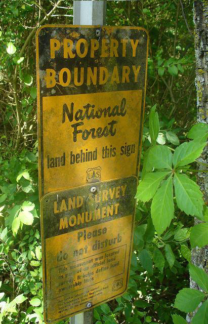
species and sizes of the trees are also recorded. Today notices are placed on
the trees. 'Land Survey Monument. Please do not disturb.' The Forest Service
shares responsibility with neighboring landowners in locating and protecting
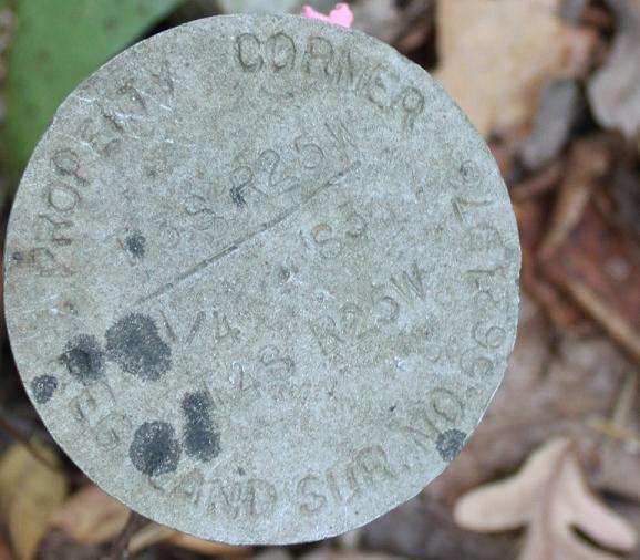
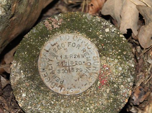
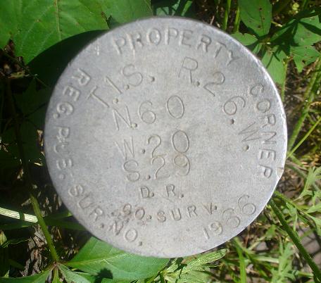
property corners and line markings along common boundaries. Property corners may
be marked with a variety of objects including, but not limited to iron pins or
pipes, rock mounds perhaps with wooden stakes and stamped monuments. Usually
two or more marked and tagged witness trees reference a corner marker and
the description of them are filed at the local land district office and a
survey marker.
Resurveying: Most of the forest lands in Arkansas and Oklahoma were
required in the early 1900s before either State began to license land
surveyors. Occasionally old property corners and boundary lines are found to
be mis-located or obliterated enough to make a re-survey necessary so build
structures away from the boundary line to avoid structure relocating and
tree hazard from adjoining NF land. The resurvey record is coordinated with the original
record. Surveyors were
required to blaze each bearing tree with the number of the tier, range, and
section in which it stood. BT: A bearing tree is a marked tree used as a
corner accessory; its distance and direction from the corner being recorded.
Bearing trees are identified by prescribed marks cut into their trunks; the
species and sizes of the trees are also recorded. Today notices are placed on
the trees. 'Land Survey Monument. Please do not disturb.' The Forest Service
shares responsibility with neighboring landowners in locating and protecting
property corners and line markings along common boundaries. Property corners may
be marked with a variety of objects including, but not limited to iron pins or
pipes, rock mounds perhaps with wooden stakes and stamped monuments. Usually
two or more marked and tagged witness trees reference a corner marker and
the description of them are filed at the local land district office and a
survey marker.
The two yellow metal signs mark the bearing trees so if you find one sign look for the other, it will be close by.
County Maps || Post 1917 Map || Civil Township Map ||
Twp 4 south range 23
 |
 |
 |
 |
Where to find records:
Personal Property tax lists show the taxpayers, their township of residence and school district so year by year searching can help pinpoint a death date or migration in and out of tax county and you can work out who is living in the same area. Sometimes you will find a comment e.g. gone to Texas or dead. The 1878 book contained twenty columns.
Property Evaluation Montgomery County, AR:
In 1900 the estimated value of real property of the county was $882,041 and assessed valuation was $282,100. Personal and real property assessed valuation reached a peak of $2,079,254 in 1927, gradually declined to $895,997 in 1938 but climbed in 1939 to $936,232. The figure dropped in 1940 to $ 890,024.Courthouse inside a framed copy. Township 2 South, Range 26 West plat map contains the present day county seat and courthouse. The original plat maps were drawn from the field notes of the survey of the Louisiana Purchase which began in the fall of 1815 and continued until the mid 1850s. The notes at the bottom describe the parcel of land, when surveyed, by whom and the date when the plat was certified. The Commissioner of State Lands office, located in the historic state capital building, was renovated in late 2012 to preserve and showcase the historic land office records they hold in trust.
Taxes extended against the personal property in Montgomery County, Arkansas for the year 1913.
A.C. Wilhite - Date paid 1/29 Number of: Value: Persons 1 Cattle 6 $30 Horses 1 $25 Mules 4 $100 Hogs 3 $5 Carriages 1 value of Car $10.00 School District 65 Total Taxes $4.37 List of Persons assessed for taxation in Montgomery County Townships in 1872
Big Fork | Caddo | Gap | Mazarn | Mountain Polk | South Fork | Sulphur Springs
Personal Property assessed for taxation included horses, sheep, cattle, number of gold and silver watches, pianos, value of money and credit balances, goods and merchandise. Transcribed from handwritten records in good faith from the 1872 book held at the Montgomery County Courthouse, Mount Ida, AR. Check original book to obtain further information.
Links
History
Land Record Reference
1845 & 1846 Tax List Polk Co. AR
Yeargan
Montgomery Co. ARGenWeb Project
2nd
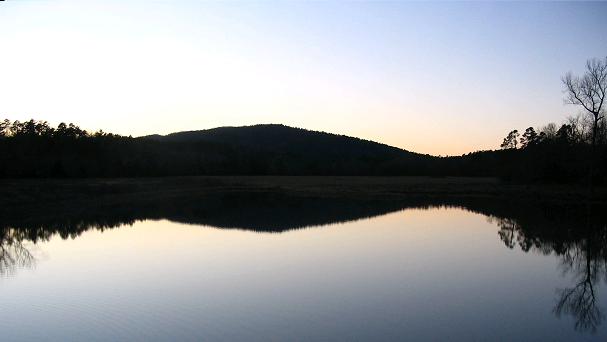
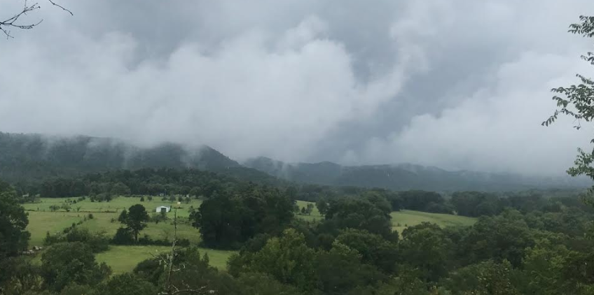
Sept. 2020. From the vista between Mt. Ida and Pencil Bluff. The
river was up. It would be nice to catch a sunset here.
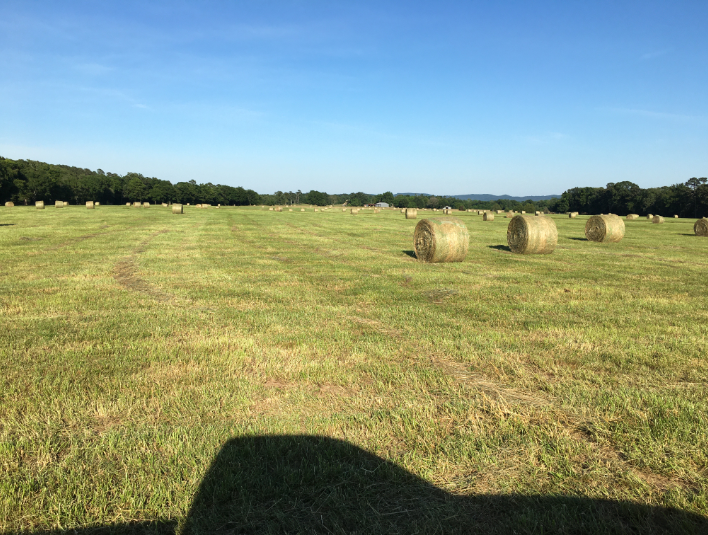
Oden, June 15, 2021, a hot spell, 270 bales (the 4x5), farmers in the district were all raking and baling hay.