![]()

Marion Co TOC
Homepage
Awards
Cemeteries
Census Records
Courthouse Info
Family Genealogies
Heritage Society
Society's Newsletters
History + more
Marion History-book
Maps
Marion Co Timeline
Marriages
Mt Meadow Massacre
Newspapers
Obits
Photo Gallery
Post Office History
Townships
Transcribed Records
Helpful Links
Contact -
Jeana
Graphics by Rhio

Marion Co, AR
Independence Township
Information & Map
![]()
Independence Township was first created in 1862 from parts of Rapps Barren and Whiteville Townships.
This Independence Township only appeared on the 1870 census with a population of 226.
On Mar 24, 1873 Baxter County was formed and a part of Marion County was used in the creation of Baxter County. At the time Marion County extended to a line about five miles east of the present site of Mountain Home to what is known as the Barton place on Tracy Ferry. In 1873 Marion County had no representative in the legislature so no objection was filed. Independence Towsnhip was one of the townships included in the newly formed Baxter County.
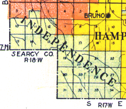
In 1908 a new Independence Township was created from parts of Hampton and Prairie Townships over on the Boone and Searcy Counties, AR lines. This township first appeared on the 1910 census with a population of 349.
The map below is for the Independence Township created in 1908.
If you arrived here via a search engine and/or if you don't understand Townships please click on the "Return to Township Index" link below for information.
![]()
Townships 16 & 17 N - Ranges 17 & 18 W
![]()
Return to Township Index
Return to Townships Timeline
Return to Map Index
Return to Marion Co Home Page