![]()

Marion Co TOC
Homepage
Awards
Cemeteries
Census Records
Courthouse Info
Family Genealogies
Heritage Society
Society's Newsletters
History + more
Marion History-book
Maps
Marion Co Timeline
Marriages
Mt Meadow Massacre
Newspapers
Obits
Photo Gallery
Post Office History
Townships
Transcribed Records
Helpful Links
Contact -
Jeana
Graphics by Rhio

Understanding Townships
Within
Marion County, AR
(c) by: Linda Haas Davenport
Feel free to utilize parts of this information for your personal use or to link to this page. Copying/Pasting in whole or part on any other website, blog or any type of internet site is prohibited. For all other uses please contact Linda (email at bottom of page)
I had often heard that my grandmother was born in Flippin, but her step-siblings were born in Jimmies Creek and her elder siblings were born in White River. When I was brand new to researching my family history I spent a lot of time looking for towns called Jimmies Creek and White River. It took me awhile to discover that those two places were county townships not towns.
To further confuse the issue Marion Co has two types of Townships: one is called County Townships and are established by the county's government; the other is called Congressional Townships and they are a part of the Federal land surveying system used to identify all land locations in Public Domain lands. The easiest way to tell them apart is simple - County Townships have names, Congressional Townships have numbers.
NAMED TOWNSHIPS:
The townships most people researching in Marion County are familiar with are ones with a name, such as my example of Jimmies Creek and White River. Today when someone asks us where we live we respond with the name of the town or city that is included in our postal address. However, in the early days towns were few and far between. Unless someone actually lived in a town the response to "where do you live?" or "where were you born?" was usually the name of a county township - as it existed at the time of the event in question. Not understanding that county townships can, and often did, change boundaries or names or even disappeared over time has tripped up more than a few family historians.
We find references to these township names in many of the old records. If you look through the abstracts of the Mt. Echo newspaper you will find numerous references to these townships. For example: "News from Jimmies Creek" or in the "Marriage Licenses Issued" section it often gives a township name as the person's residence. Most importantly, what the US Census Bureau refers to as Minor Civil Divisions were the most common way to assign an area to an Enumerator (census taker). For Marion County that means by townships.
County Townships boundaries changed over the years (and are still changing although much slower) for a multitude of reasons. The most common is because of a population change within the township. In the case of Marion Co it's almost impossible to determine the actual dates and reasons since so many records were lost in the Courthouse fires.
Nowadays we family historians have gotten spoiled as more and more digital records come online. How simple - plug in a name a few facts and you can probably find an ancestor. But, what if you dream of finding the place your ancestor lived or to even walk on the land they owned? What if you'd like to discover that family graveyard you've heard was down by the little creek? Or, perhaps you're wondering it that church where your great-grandparents married is still standing?
If you are researching in Marion County and you want any of these things it's extremely important to know when and how a county township boundaries changed. You'll find a timeline of these township names and changes here on the Marion Co site. It's a necessary piece of our research puzzle.
CONGRESSIONAL TOWNSHIPS
The other type of township found in Marion Co is called a Congressional Township. This type of township was established when the Federal Government opened and surveyed a new area of land. Congressional townships' "names" and boundaries never change. County lines or even state lines may change, but the original land survey townships do not.
(Understand and using Land Records in our research is complicated. In fact complicated enough that I wrote a book about just that. For our purposes here I'm going to try to simplify this extremly complex subject.)
If you are that family historian who dreams of finding and walking on the actual property where your ancestor(s) lived understanding and using Congressional Townships helps makes that possible.
The American Colonies were established mainly with people from England and they brought with them England's Common Law. One of those laws had to do with how to describe a piece of property in a deed. When a piece of property is sold the deed must include a description of the property that describes the property and location of the property in such a way it cannot be confused with other piece of property. Unfortunately these early descriptions described the boundaries using such things as natural features (creeks, rivers, trees) or naming neighbors boundary lines or by painted stakes. These types of property descriptions were subject to change when a tree died, a creek or river changed course, or painted stacks was moved. This type of description resulted in multiple land disputes over the years. The states that use this type of property descriptions are called State Land States.
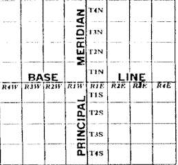
After the Revolutionary War the new U.S. government found itself the owner of a lot of land known as Public Domain Land. To raise money the government decided to sell off some of its land, but before it could do that it had to determine a way to identify the land to be sold. The result was a new way to survey land. The new surveying system, commonly called the U.S. Land Survey System, was designed and put into use. In this system an area of land is overlaid with an imaginary grid of squares. Each square within the grid is uniquely identified with location designations - Section, Township, Range and Merdian (smallest to largest). Each square is continually broken down into smaller pieces, while still keeping the land in identifiable squares. This system results in every piece of land in the Public Domain being uniquely identified and ensures a particular piece of land cannot be confused with any other.
A state where this surveying system is used is call a Public Domain State. Arkansas is such a state. If you have a deed from Marion County, you'll see the property described as something along these lines ... "SW1/4 or the NE1/4, TS19N, R16W, 5th Meridan." Spelled out this shorthand description reads: The Southwest quarter of the Northeast quarter of township 19 north, range 16 west of the 5th meridan.
The official definition of the US Land Survey System is:
"The US Land Survey System is cartographically represented by lines running North and South and East and West. These lines are 6 miles apart and the squares formed in this manner contain 36 square miles and are called Townships. This system of survey starts from the intersection of a principal Meridian and a Base Line, (the intersection of the Meridian and Base Line is the center of the large piece of land being surveyed.)
The way this works is: the numbers starting from each intersection of the principal Meridian and Base line, increasing North or South along the meridians are known as Township Numbers and those going East and West along the Base lines are called Range numbers."
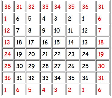
For a real life example look at this Marion Co map showing townships with section lines and numbers. Within each township you will see small numbered squares. These little numbered squares match the numbers in the above box. Looking at the top and bottom of the map you'll find the Range numbers and on the left side you'll see the Township numbers.
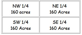
Each one square mile Section (box above) contains 640 acres and is divided into quarters containing 160 acres each:
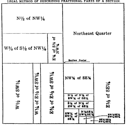
As property is sold each of these quarters are broken down into smaller and smaller pieces, with all pieces keeping the N, S, E, W designations
Map courtesy of: Gallup Map & Supply Co Kansas City, MO
With this type of standard identification it is easy to locate a particular piece of property today if you know the section / township / range location.
When new land was opened for settlement the Federal Government sold land and issued deeds called Patents. When the Homestead Act went into operation on May 20, 1862 people could apply for free land. As with everything the government does paperwork was generated and, luckily for us, that paperwork is still available.
COMBINING THE TWO TOWNSHIPS:
Marion county was formed Nov 3, 1835. On the evening of Wednesday Aug 10, 1887 Marion County's courthouse burned to the ground, taking with it almost 52 years worth of records and county history since nothing survived the fire. After the fire current landowners were encouraged to bring in their deeds to be re-recorded. Those that were re-recorded are only a tiny, tiny portion of the deeds that were recorded through the years. Some of the indexes to the re-recorded deeds are found here on the site.
If your ancestor is not found in the First landowners maps and indexes or other records here on the site (for example: Property Tax records, legal notices in the Mt Echo), you have to work a bit harder in your search for your ancestor(s) land. Here on the Marion Co site are maps that will allow you to go from a County Township to a Congressional Township which in turn will allow you to locate a County Township on a current day roadmap and to narrow your search to a small area.
At the Townships maps page are two sets of maps. One set are County Township maps and the other are Congressional Townships maps in which County Townships are found. To locate a piece of property you'll need to combine the two. Go first to the set of maps labeled County Townships, find your township(s) name and open the map. Above the map is noted the Township and Range the County Township is located in. Using that information open the matching Township/Range map. (These maps were snipped from a 2008 map.) Both sets of maps show Section numbers. Comparing the two you can determine the boundaries of the County Township within the Township/Range maps. Armed with all of this information you can continue the hunt for your ancestor(s)' property using such things as towns, rivers, creeks and any other information you may have to help identify the Section number.
(If you'd like a more in-depth explanation check out my Land Records Tutorial [opens in a new tab or window]
If I can answer any questions for you drop me a note.
Return to Townships Index
Return to Landowners Index
Return to Map Index
Return to Marion Co Home Page