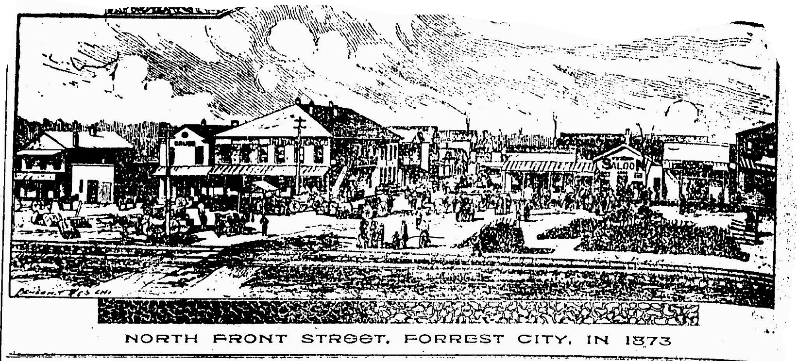
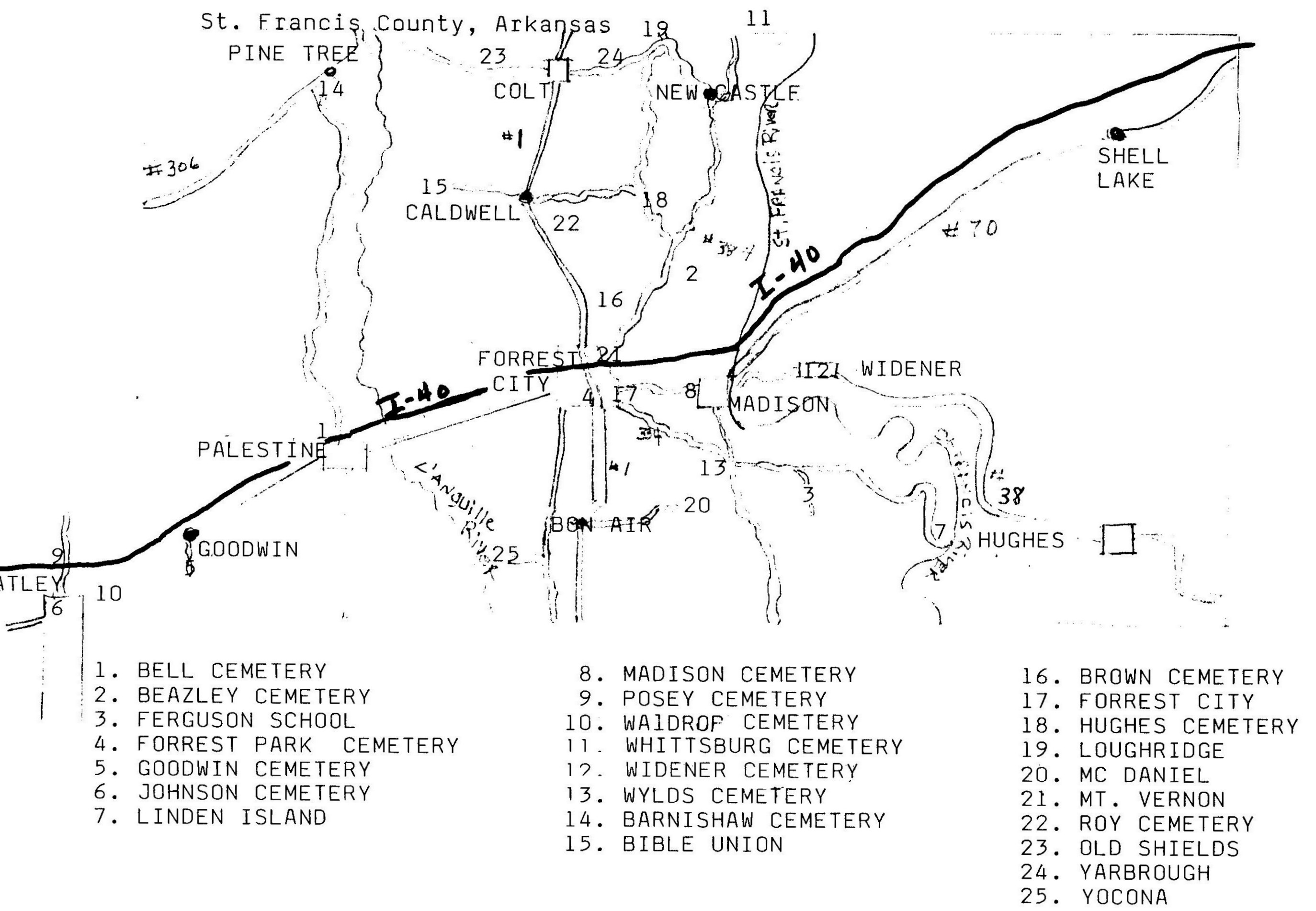
|
|
I WELCOME and ENCOURAGE
the contribution of St.Francis, AR
information and links to this website. All
information is credited to whom credit is
due, with special thanks to Times-Herald Publishing for permission to use their material. Thank you for visiting the site and I
hope you find something useful or that you
enjoyed.Special thanks to Sandy Hardin, who designed my page!
This site is a proud part of The Original
Arkansas Genealogy Project.

email
Paul V.Isbell-
St.
Francis Co., Arkansas ARGENWEB
|
           
           
Other Links
Greene County
Website-Greatest
          
           
Rootsweb
Message Boards
This is the St.Francis County., AR Mailing list


Web Host.
DISCLAIMER: The St. Francis County,
Arkansas Homepage has no affiliation
with any commercial enterprise. Copy of
any material contained in this Homepage
for any use other than research is
strictly forbidden without prior written
permission of Forrest City Times-Herald Publishing Company or Paul V.Isbell.
St.
Francis County, Arkansas was created by
The Arkansas Territorial Legislature on
October 13, 1827 taking in part of
Phillips County.
Originally St. Francis County was larger
than the 635 square miles presently
contained within its boundaries. The
county is bounded on the north by
Crittenden County and Cross County, on
the east by Crittenden, on the south by
Lee County, and on the west by Monroe
and Woodruff Counties. St. Francis
County is divided into twelve townships;
Garland, Heth, Griggs, Johnson, Telico,
L'Anguille, Blackfish, Franks, Prairie,
Goodwin, Madison, and Wheatley.
The St. Francis and L'Anguille Rivers
cross the county from north to south
dividing it into nearly three equal
divisions. Crowley's Ridge runs nearly
equidistance between the two rivers and
has an average altitude of 300 feet
above sea level. The seat of justice and
the principal city is Forrest City
located on Crowley's Ridge and in
Madison Township. Forrest City is named
for the Confederate Cavalry Officer,
General Nathan Bedford Forrest. There
are numerous smaller towns and villages,
the most important of which are; Hughes,
Widener, Madison, Palestine, Wheatley,
Caldwell and Colt.
The site for the seat of justice was
first located in the town of Franklin
(Franklin no longer exists), originally
named Cherokee Village when the area was
Phillips County. The county seat
remained at Franklin until 1841 when it
was removed to the town of Madison. For
a short period in the year 1855 the seat
was moved to Mt. Vernon and returned to
Madison where it remained until 1874. In
1874 the seat of justice became
permanently located at Forrest City.
In the north part of the county is Colt.
An act of Congress in 1821 authorized
the construction of the Historic
Military Road from Memphis, Tennessee to
Little Rock, Arkansas. This road
followed a trail from the Mississippi
River to the crossing at the St. Francis
River at a point near the present line
between Cross and St. Francis Counties
and continuing on a course due west and
nearly parallel with the county line
following a course through Taylor's
Creek, later named Colt, and continuing
through L'Anguille Township and then on
to Little Rock, Arkansas. This road
proved to be important to the early
settlement of St. Francis County.
The above information about St.Francis
County was prepared by Loyd N. Sybert.
The purpose of this page is to aid you
in your search for St. Francis County
residents. It is hoped that the
information contained here will help
you; to understand how and when the
county boundaries changed, to find the
names of some of the prominent families,
to use other sources of information, and
how to contact others researching
families that may be connected to your
lines of research. If you would like to
contribute your information to this page
or if you would like to publish a page(s)
for this County, please let me know.
|
This page was last updated
June/28/2008 11:58 AM
Sign
My Guestbook
View
My Guestbook
|