|
Name |
Location |
# of Marker Photos |
Road Maps |
Owners Plats |
Al Lee Cemetery |
Located on Al Lee farm off of Hwy 253, a short distance from Lavaca. |
|
|
|
|
S. of Hwy 96 in NE Sebastian Co |
144 names
28 photos |

T9N R29W Sec 31 |

T9N R29W Sec 31 |
|
From the town of Hartford take West Hartford Rd. to Poteau Mtn. Rd. turn South go 1.6 miles to gas company gate on left and pig trail
leads back to cemetery. Near the West Harmony Cemetery |
17 names |

T6N R30W Sec 20 |
T6N R30W Sec 20 |
Barling Cemetery
off site link |
see.... Spring Hill Cemetery below.
Located South of Barling, Ar this cemetery was
originally called Spring Hill until a few years after the town become Barling. |
9 names
9 photos |

T8N R31W Sec 34 |
T8N R31W Sec 34 |
|
Was located on Walter Brock Farm. Go south on highway 45 out of Hackett, Arkansas..about 2.7 miles, then turn right on the second
dirt road; go approx. 6.5 miles and turn left, then go approximately .8 of a mile. The cemetery is on the north side of the road and is back under some VERY
large cedar tree. |
14 names
13 photos |

T5N R32W Sec 28 |
T5N R32W Sec 28 |
|
So of Hwy 10 on Hwy 252, at Washburn |
61 names
64 photos |

T6N R29W Sec 28 |
T6N R29W Sec 28 |
|
inaccessable by road....located On Frank Brixey's property along an old wagon road that was used to go from Hwy 10 to Old Hwy 10. |
6 names |
|
|
Bethell / Green Floyd Cemetery |
see... Green Floyd Bethell Cemetery below
Located South of Mansfield |
|

T4N R31W Sec 12 |
T4N R31W Sec 12 |
Beverly / Carter Family Cemetery at Beverly, Ar
|
See Carter Family Cem at Beverly, Ar below |
|

T8N R28W Sec 33 |
T8N R29W Sec 33 |
Blaylock Family / Sand Ridge Cemetery |
see.....Sand Ridge / Blaylock Cemetery below
Originaly named Sand Ridge Cemetery |
|
|
|
|
Exit Highway 71 South onto Highway 10 West and travel to Hwy 253, exit south, proceed 5.7 miles, exit left by blue
metal building across from coal washer. Cemetery is located one half mile back into the forest along the electric line right-of-way. (Directions
from Ft Smith Library) |
|
|
|
|
Located NE of Bonanza, 2.3 miles east of Hwy 45 off of White Bluff Road on Dolan Way, behind the Dolan house,
2nd house on the right. |
11 names
11 photos |

T7N R32W Sec 14 |
T7N R32W Sec 14 |
|
Located 6 miles from Fort Smith |
2 names |
|
|
Bloomer / Morris Cemetery |
see..... Morris Cemetery below
Early called Bloomer Cemetery, changing later to Morris Cemetery |
|
|
|
| |
located south of Salem City |
6 Obits |
|
|
Brown Farm Cemetery |
The original name of this cemetery is unknown. It is located on the farm of Robert Brown, on the west edge of a grove of
four cedar trees, and to the southwest of a metal building near the entrance to the farm. The farm is located about 1000 yards from
the fence line at 1010 West Hartford Road, which is about 0.4 mile from Hwy 96 west of Hartford, Arkansas.
According to local residents the cemetery was started in the 1850s. Sam Story of the area is credited for saving the gravesites
from a bulldozer, but was only able to document the names of three graves.... from "Directory for Cemetery Locations, Publications,
and List of Death Source Reference Material for Sebastian County, Arkansas". |
|
|
|
Buggy Hill Cemetery
off site link |
West of Hwy 378 and No of Co Hwy 13, south of Mansfield, Ar |
110 names
107 photos |
T4N R31W Sec 2 |
T4N R31W Sec 2 |
|
NE of Huntington, Ar. East of Co. Hwy 80 & So of Co Hwy 82 |
26 names
26 photosComplete |

T5N R30W Sec 10 |
T5N R30W Sec 10 |
|
Travel Hwy 96 north of Lavaca to Burkett Lane, exit left, proceed to the end of this street, a cemetery is
on the left, at the street. |
|
T8N R29W Sec 30 |
T8N R29W Sec 30 |
|
NE of Dayton Cemetery bewteen Stinebaugh Lp & Hwy 252 |
12 names
12 photos complete |
T5N R30W Sec 10 |
T5N R30W Sec 10 |
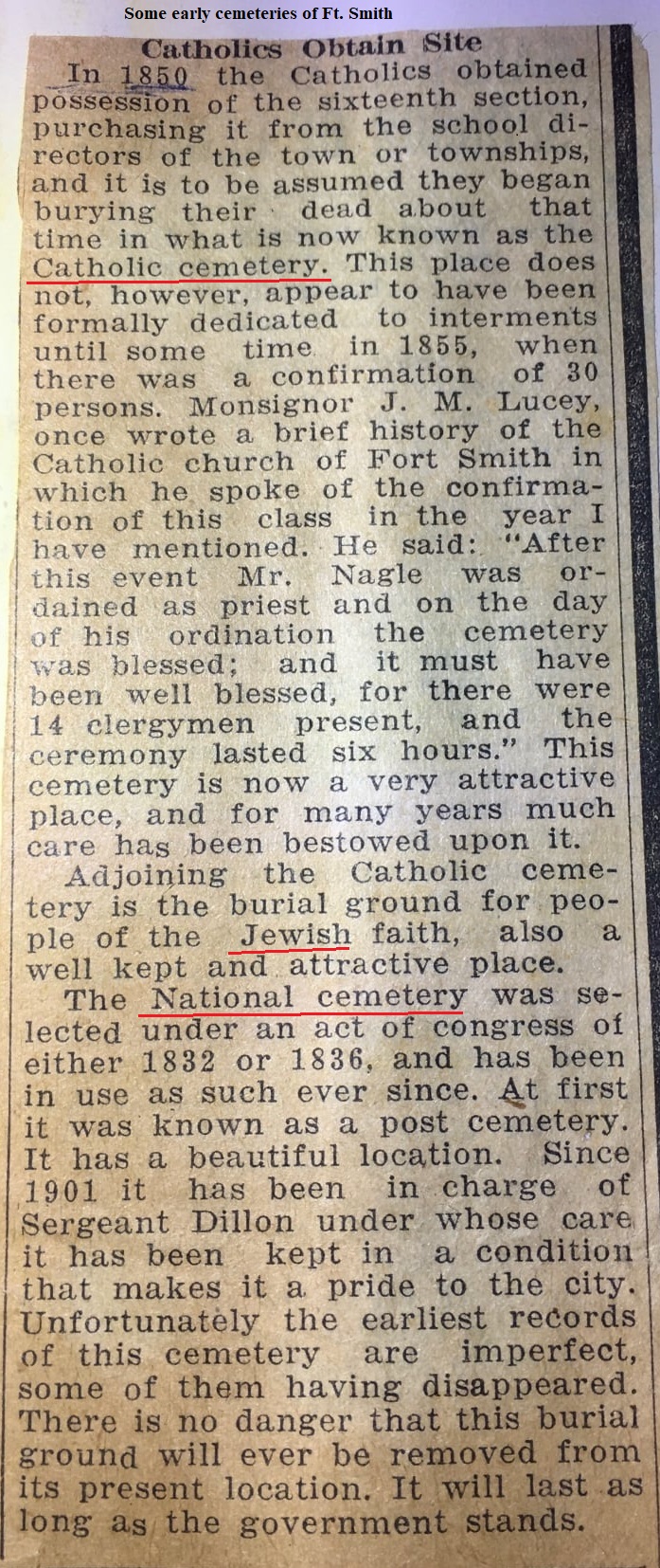
| (formerly Catholic Cemetery) |
Ft. Smith, East of Towson Ave, between So."F" and So."H" Sts. |
3100 photos |
|
|
|
On Massard Prairie |
5 Obits |
|
|
|
on Highway 96, northeast of Lavaca, approximately halfway between Lavaca and Arbuckle Island Road, situated a few yards off the
highway on your left, but visible. |
18 names
18 photos |
T8N R29W Sec 18 |
T8N R29W Sec 18 |
also known by some as Beverly Cemetery |
Go east of Lavaca on 96 and turn right on the curve on Military Road.
Turn left at the stop sign onto Highway 252. Approximately four miles north on 252 there will be
a hill with large trees. At the top of that hill you will see a mailbox 2417 and turn onto that
private driveway. Almost immediately left is the cemetery surrounded by large old stones. |
6 names
5 photos
1 obit |
T8N R28W Sec 33 |
T8N R29W Sec 33 |
|
So of Hwy 22 on Fort Chaffee property on Potato Hill Road, abt. half way between Hwy 96 and Hwy 217. |
1 nameComplete |

T7N R29W Sec 19 |
T7N R29W Sec 19 |
|
South of Lavaca |
3 Names |

T8N R30W Sec 34-35 |
T8N R30W Sec 34-35 |
Catholic Cemetery |
later named Calvary Cemetary. See it above. |
|
T8N R30W Sec 34-35 |
T8N R30W Sec 34-35 |
Cavanaugh /Leard Cemetery See Leard Cemetery |
Located south of Cavanaugh, Ar. and now spreads across the state line into Oklahoma. The origional cemetery was in Arkansas.
First called Cavanaugh Cemetery as shown on some obituaries, it was later named Leard Cemetery.
Part of the graves are in Oklahoma and the other part are in Arkansas.
There is a fence line on the east side that runs all the way except for about 100 feet it then goes back about 100 feet this area
about 100 X 100 is the origional Leard Cemetery and when it expanded pre 1900 it went into Oklahoma. There is an old slave cemetery
in the wooded area that adjoins this cemetery
On Find A Grave Richard Meador writes....there are 58 known burials that are in Arkansas but many are not marked.
All burials that are marked on the Arkansas side are pre 1900. |
|
|
|
Center Point Cemetery |
A section of Mt.Harmony Cemetery -
See....Mt Harmony Cemetery |
|
T6N R30W Sec 20 |
T6N R30W Sec 20 |
|
So of Hwy 22 on Auburn Rd....on Camp Chaffee property west of Charleston |
104 names
7 photos |
T7N R29W Sec 18 |
T7N R29W Sec 18 |
|
Near Jenny Lind |
1 Obit |
|
|
|
Cherokee African-American Cemeteryoff site link |
Originally known as Cherokee Chapel Graveyard
History of Cherokee African American Cemetery
Located just north of 252, and East of Co Hwy 32... west of Huntington, Ar |
109 photos
Complete |

T5N R31W Sec 27 |
T5N R31W Sec 27 |
City Cemetery - Fort Smith |
See Oak Cemetery |
|
|
|
|
Located SE of Midland, Ar, So of Co Hwy 21 at the end of Co Hwy 196 |
4 names
4 photos |
T5N R32W Sec 34 |
T5N R32W Sec 34 |
Clarkeen / Ramsey Cemetery |
see.... Ramsey Cemetery below |
|
|
|
|
Part of the Old Oak Cemetery, Ft Smith |
27 names
|
|
|
|
Located on Clarks Chapel Rd about two miles north of Witcherville off Highway 71 |
208 photos |
T6N R30W Sec 31 |
T6N R30W Sec 31 |
|
Witcherville, Ar. |
1 Obit |
|
|
|
On Ft. Chaffe, east of Greenwood, north of Hwy 10 |
23 names |
T6N R30W Sec 12 |
T6N R30W Sec 12 |
|
NE of Mansfield on Sebastian/Scott Co. line in Scott Co. |
1164 photos |
T5N R30W Sec 31 |
T5N R30W Sec 31 |
|
So of Hwy 22 and East of Hwy 96 on Fort Chaffee in Bloomer area, exit Hwy 22 right [south] onto Auburn Road, proceed a short distance, cemetery on east side of road.
property on Carnis Auburn Rd. |
4 Unknowns |

T7N R30W Sec 27 |
T7N R30W Sec 27 |
Cornish Cemetery |
Originally at Fort Chaffee, removed to Liberty Cemetery. |
|
|
|
|
1 mile W of Greenwood, E of Hwy 71 on CR 51 |
435 photos |

T6N R31W Sec 10 |
T6N R31W Sec 10 |
|
Located on the northside of Greenwood on the corner of Summit Ridge Drive and North Main Street.
It appears to be a small family cemetery. |
9 names
4 photos |
T6N R31W Sec 1 |
T6N R31W Sec 1 |
|
No of Midland, Ar, So of Co Hwy 27 and W of Hwy 253 |
14 names
14 photos |
T5N R31W Sec 18 |
T5N R31W Sec 18 |
|
SE of Greenwood, Ar. By Milltown. So of Hwy 10 and W of Hwy 252 on Co Hwy 77. |
454 names
4 photos |
T6N R30W Sec 26 |
T6N R30W Sec 26 |
|
Located on Dayton Road. Turn off US HWY 71 South in Witcherville onto Dayton Road. Follow this for a couple of miles. It will be on the
LEFT side of the road |
158
photos |
T5N R30W Sec 10 |
T5N R30W Sec 10 |
Dearen Cemetery |
Same as Cornish/Auburn on Ft. Chaffee, west of Hwy 96 |
|
T7N R30W Sec 28 |
T7N R30W Sec 28 |
Cross Roads Cemetery |
NE of Mansfield; T5N R30W Sec15
| |
|
|
Doubleday/Pleasant Hill Cemetery |
See.....Pleasant Hill Cem. below
E of Hackett, Go South from Hwy 10 & 253 on Co Hwy 45 then east on Co Hwy 47. On North side of road. |
|
|
|
Once known as Long Prairie Cemetery |
So of Hwy 71 between Ft. Smith and Greenwood on east side of Co Hwy 57 and south side of Co Hwy 54 |
184 photos |

T7N R31W Sec 31 |
T7N R31W Sec 31 |
|
Located just east of the Dawson Cemetery, near Milltown, Ar. The old Mt. Zion school used to be across the road
from this cemetery. |
13 Names |
|
|
pauper graves |
So. Zero, south edge of Ft. Smith |
297 names
13 Obits
8 photos |
|
|
|
see....White Bluff Cemetery below also
North of Bonanza.
Became White Bluff Cemetery abt 1902-04. |
9 names
5 Obits |
T7N R32W Sec 33 |
T7N R32W Sec 33 |
Eppler/Lone Star Cemetery |
See Lone Star - T6N R29W Sec18. On Franklin Co line |
|
|
|
Evans Cemetery |
"Small cemetery located on the property of Mike and Judy Johnson. Address 201 Gordon place, Greenwood, Arkansas, 72936
The grave of Miss Delilah Evans b. 18 July 1822 in TN., d. 29 Oct. 1872 AR, is the only grave with a headstone. There are about 10-12
unmarked graves there. Possible burial place of Burwell Patrick Evans b. 1794, TN, d." |
1 names
|
|
|
|
Near Excelsior. Take Hwy 10 from Greenwood, west to Hwy 253 South about 1/4 mile to Excelisor Rd go east about 1 mile
it will be on the South side of the road. It has a chain link fence around it. |
367 names
367 photos |
|
|
|
Near Phoenix Avenue, formerly Mill Creek Road, and on the other side of Southtown |
19 names
3 photos |
|
|
|
2 miles east of Greenwood |
5 names
0 photos |
|
|
Forrest Park Cemetery
Off Site Listings |
Ft. Smith,Ar. NW of Midland Blvd and SW of Hwy 255 or Clayton Expy. |
|
|
|
Gardner Cemetery |
Newspaperman, W. J. Weaver identifies the first
graveyard in Fort Smith as being "on a grassy knoll, on the bank of the Poteau, close
to the present iron foundry."
In an article entitled, "Reminiscent," appearing in The
Elevator, 18 December 1896, Weaver recalls that, "In 1840 there were three marble
slabs standind (sic)." He mentioned that one was the grave of a surgeon and two were
lieutenants. [Fort Smith Original Military Cemetery]
This site is believed to be the
same burial ground referred to by Mr. Kannady, as being established, when he arrived
in 1836, and was also referred to as the Gardner Cemetery.
In the 1880s Dr. H. T.
Main sold this tract of land with the burial ground, and it is reported the new
landowner rolled the tombstones off of the bluff into the Poteau River, and tilled the
soil.
Source: DIRECTORY FOR CEMETERIES, NAMES, LOCATIONS, AND REFERENCES FOR SEBASTIAN COUNTY, ARKANSAS |
|
|
|
|
NW of Greenwood, South of Co Hwy 8 |
142 names
118 photos |
T7N R31W Sec 35 |
T7N R31W Sec 35 |
|
Located at the intersection of Co Rd. 38 and Co Rd. 40 which are west of Hwy 96 and south of Greenwood. |
557 photos |
T6N R31W Sec 28 |
T6N R31W Sec 28 |
|
Located south of West Liberty Cemetery |
2 names |
|
|
|
Take 378 south out of Mansfield. Turn right off 378 to Elmore Road. Go up two big hill. There is a side road just after the 2nd hill,
turn left on it. Go down that road and you will run into a fence.
Cemetery is there in the pasture. The land belongs to Howard Hattabaugh and you MUST get permission to enter his pasture. |
22 photos
complete |
T4N R31W Sec 12 |
T4N R31W Sec 12 |
also known as
Greenwood City Cemetery |
located at the edge of Greenwood, Ar |
575 photos |
T6N R31W Sec 12 |
T6N R31W Sec 12 |
|
Located 1.3 miles east of Bonanza on Sherwood Ave on the north side of the road about 500 feet on a knoll with trees around it.
|
13 names
5 photos |
T7N R32W Sec 14 |
T7N R32W Sec 14 |
|
Bonanza area. This cemetery is located about 1/4 mile South West of the Haug Cemetery. There is only one known burial. It is located
on private property and permission is needed to enter. |
1 name
2 photos |
|
|
|
Location: Sebastian Lake Estates north of Hackett. |
1 Obit
1 name |
|
|
|
Located west of the city of Greenwood, north of Old Hackett Road,
on hill behind the Nazarene Church. The Old Hackett Road connects with old Hwy 7, and new Hwy 71 at Greenwood |
25 names
1 photo |
|
|
Hartford Memorial Park Cemetery / Center Point Cemetery |
Hartford Memorial Cemetery was called Center Point Cemetery until around 1935-40. There is a section of the cemetery still
known as the Center Point Section. There is still a road that is to the east of the cemetery called Center Point Rd. |
756 photos |

T4N R32W Sec 11 |
T4N R32W Sec 11 |
|
Located on the Acee Dairy farm 1/2 mile east of Bonanza on Sherwood Ave., Turn south on Dutch Lane for 1/8 mi.
Cemetery is on the right. |
15 photos |
T7N R32W Sec 14 |
T7N R32W Sec 14 |
Hendrix Hill |
Located in Fort Smith. A neighborhood of housing was built over it....named Hendrix Hills. The home on the cemetery was owned
by a Steed family a few years ago. The marked graves were moved....but WHERE? The only cemetery resident I have seen listed as buried there was
an Annie Eliza Bond Bray buried in 1902. There apparently were more. |
|
|
|
|
Located NE of Lavaca (Take Hwy 22W from Ft. Smith to junction of Hwy 252, turn north and go several miles to Craft Road [past Sullivan
Road], take a right and go about 3 miles. The cemetery is on a hill in a curve, on the right side of the road just before the Franklin County
line.) |
63 Names
63 photos |
T8N R29W Sec 15 |
T8N R29W Sec 15 |
|
Ft. Chaffee |
1 unk grave |
|
|
|
Bet. Lavaca & Ursula. East of Hwy 252, No. of Co. Hwy 70 before you reach Co. Hwy 286. |
19 names
19 photos |
T8N R29W Sec 15 |
T8N R29W Sec 15 |
Hicks Cemetery / New Providence Cemetery |
see...New Providence Cemetery below
Location - Slaytonville, Ar |
|
|
|
|
On Ft. Chaffee property south of Central City |
1 name, many unk. |
T7N R30W Sec 6 |
T7N R30W Sec 6 |
Hinton Graveyard |
T7N R29W Sec25 |
|
|
|
Holy Cross Cemetery
off site link |
Ft. Smith....located between No 53th street and I 540 |
|
|
|
Hood-Weindel Cemetery |
Orignally on Ft. Chaffee, moved to White Cemetery |
|
|
|
off site link |
Lexington Avenue, Fort Smith-south side by fence on North "H" Street side. |
138 photos |
|
|
Howard Hill Cemetery |
NE of New Jenny Lind on Howard Hill Rd. (Greenwood area. Exit east from U.S. Hwy 71 south of Fort
Smith onto Howard Hill Road, cemetery located where road intersects with Gate Nine Long Ridge Road.) |
|
|
|
|
Also known as Memories Cemeery; Take Hwy 71 north out of Huntington and turn west of Co Rd 30. Located on south side of 30. |
357 photos |
T5N R31W Sec 23 |
T5N R31W Sec 23 |
Indian Cemetery |
Bonanza |
|
|
|
Indian Rock Road Cemetery |
Location: North side of Indian Rock Road, exit Hwy 45 south of Hackett at Indian Rock Road and proceed almost
to the Oklahoma state line |
|
|
|
Indian Cemetery |
Located on Ft. Chaffee property south of Central City.
Also known as an African American burial ground, and has been referred to as a Civil War burial ground. |
|
T7N R30W Sec 7 |
T7N R30W Sec 7 |
|
Located on Hwy 96 north of Lavaca (sometimes called Arbuckle Island Cemetery-not to be confused with
Arbuckle Cemetery) |
221 names |
T9N R29W Sec 31 |
T9N R29W Sec 31 |
Jackson / Red Yard Cemetery |
Earlier known as Red Yard.
West of Hartford on Co Hwy 23 that goes north off of Hwy 96. |
91 names
83 photos |
T4N R32W Sec 8 |
T4N R32W Sec 8 |
|
Located between Mansfield and Hartford (AR) on private property owned by Linda Welden. Contact her at
lwelden@lightspeed.net for access and directions to the cemetery. |
90 names
86 Photos
Complete |
T4N R31W Sec 7 |
T4N R31W Sec 7 |
|
|
232 photos |
|
|
|
Located on Ft. Chaffee property between Charleston and Greenwood on the south side of Carnis Auburn Rd. |
18 photos |
T7N R30W Sec 25 |
T7N R30W Sec 25 |
|
East side of Sugar Loaf Mountain Road, north of Harford short distance, east side of road. This cemetery has been cleared off to
locate chichen houses and trailer on. |
|
|
|
|
Ft. Chaffee property, NW of Washburn, Ar.
60' x 12 ' Fenced
20 graves. 1 known |
1 name
1 photo |
T6N R29W Sec 6 |
T6N R29W Sec 6 |
|
next to the old Methodist Church in Lavaca |
204 photos |
T8N R30W Sec 27 |
T8N R30W Sec 27 |
|
Located south of Ft. Smith, Ar. by Cavanaugh, Ar., on the Arkansas Oklahoma border. First graves were in Arkansas but most graves are now in Oklahoma now.
It is on Texas & Rutgers Road. See Cavanaugh Cemetery above for history |
22 names
19 photos |
|
|
|
Located at West Hartford on the West Hartford Road on the south side. It is behind the old Leatherwood home place. Take Highway 96 west
from the city of Hartford. Turn left on the West Hartford Road across from the Hartford Schools. It is on the private property of Paul Basinger.
Travel south, behind the home of Mr. Basinger down farm road through the forest abt .3 of a mile |
10 names |
|
|
|
East of Dayton, north of Apple Blossom Road. Off of Hwy 252, between Apple Blossom
road and Echo Road. It is on private property. |
12 photosComplete |
T5N R30W Sec 9 |
T5N R30W Sec 9 |
|
North of West Harmony Cemetery |
2 names |
|
|
|
North of Greenwood off of Hwy 96 and to the west of Co Rd 76. |
794 photos |
T6N R30W Sec 8 |
T6N R30W Sec 8 |
|
Located between Greenwood & Booneville north of Hwy 10 on Ft. Chaffee Property |
186 names |
T6N R29W Sec 7 |
T6N R29W Sec 7 |
Long Prairie Cemetery |
Later Douglass Cemetery |
|
|
|
|
Originally called Witcherville Cemetery.
Located at Witcherville, Ar. Turn west off of Hwy 96/71 onto
Lovelace Ct. |
197 names
121 photos |
T5N R31W Sec 2 |
T5N R31W Sec 2 |
|
Located on the No. side of Tennesse Ridge Road abt. 1/2 mi. west of Hwy 71 |
8 photos |
T7N R32W Sec 14 |
T7N R32W Sec 14 |
Manus/Tate Cemetery |
see...Tate Cemetery below
About one half mile west of the water tower which is north of the town of Lavaca, Arkansas or east of
Hickman Bluff Road northwest of Lavaca, on dirt road. Very secluded. |
|
|
|
Mannuis Cemetery |
West of Booneville and south of old Hwy 10 |
|
T6N R29W Sec 36 |
T6N R29W Sec 36 |
|
Early cemetery - was located in Ft. Smith |
1 name |
|
|
Marietta / Speegle Cemetery |
Now known as Speegle Cemetery,,,,see Speegle Cem below
Located close to Franklin Co line, south of Bloomer |
|
|
|
|
On Ft. Chaffee property, East of Barling. Travel east of Ft Smith on Hwy 22 to Barling.
It is 5 miles east of Barling on right side of Hwy 22, situated between Hwy 255N and Bloomer |
83 photos |
T7N R30W Sec 6 |
T7N R30W Sec 67 |
|
On Ft. Chaffee north of Barling, east of the Lock and Dam road |
1 name |
T8N R31W Sec 28 |
T8N R31W Sec 28 |
|
Ft. Chaffee, NE of Greenwood. |
54 names |
T7N R30W Sec 32 |
T7N R30W Sec 32 |
|
On Ft. Chaffee property south of Barling |
3 names
1 photo |
T7N R31W Sec 16 |
T7N R31W Sec 16 |
McKinna Cemetery |
In a field now owned by the Barton Brothers, on the Ponderosa Ranch, off Highway 39, east of Witcherville. |
|
|
|
McKinney Cemetery |
south of Milltown, East of Dayton, and northwest of Abbott. U.S. Hwy 71 South of Witcherville to junction 252 East, exit left, proceed
to Dayton, curving left at Church of Christ, proceed on as hwy becomes #82, past Union Ridge Cemetery, to
fork in road, take left fork to junction of Blythe Road #223. [near Logan County line]. |
|
|
|
|
Located 1/2 mile south of Hackett, Arkansas. Turn left on Indian Rock Road and go .8 of a mile. Turn across a cattle
guard at corner of Fatum Lane and Indian Rock Road. Cemetery is west of the house in the pasture. It is fenced on all sides. Located in Section
29 Township 6 North Range 32 West |
18 names
14 photos |
|
|
|
East edge of the city of Lavaca, south of Hwy 96 |
58 names
25 photos |
T8N R30W Sec 35 |
T8N R30W Sec 35 |
Midland / Mt. Olive Cemetery |
see..... Mt. Olive Cemetery below |
|
|
|
|
Near Dayton. Directions to cemetery: Located on farm of Bill Efurd. Turnoff to cemetery
is on road connecting Dayton & Witcherville and is .5 mile west of the Dayton cemetery and 2 miles east of Witcherville
& Hwy 71 intersection. Turn off road to the south and wind around Efurd farm, cemetery sits in middle of barnyard.
On land probably owned previously by Lorenzo Dow Gilstrap.
NOTE: This cemetery is on private property and is difficult to find
without a guide. It is suggested that permission to enter Mr. Efurd's land be obtained before visiting. If Mr. Stinebaugh is not available,
contact local Postmaster for present caretaker.
Cemetery caretaker in 1992 was Lester Stinebaugh. It is not known if he is living at present (1997). |
51 photos
complete |
T5N R30W Sec 10 |
T5N R30W Sec 10 |
Morley / Bell Farm Cemetery |
see..... Bell Farm Cem above
Located in Washburn area. Travel east of Greenwood on Hwy 10 to Hwy 255 junction, exit right, travel south to junction of hwy
88 [Old hwy 10] a short distance, cemetery is north of highway N.E. of Washburn |
|
|
|
|
On property f Fleetwood Morris; North of Hwy 22 on Ft. Chaffee property near Bloomer, Ar |
372 photos |
T7N R29W Sec 7 |
T7N R29W Sec 7 |
|
On Ft. Chaffee property SE of Charleston, to the north of Potato Hill Rd. |
4 Names |
T7N R29W Sec 19 |
T7N R29W Sec 19 |
Mount Harmony Cemetery
off site link |
Take Highway 10 East from Greenwood, turn right at Mt. Harmony Road and travel until you see Mt Harmony Church on the right. A sign pointing
to the cemetery is on your left. |
431 photos |
T6N R30W Sec 20 |
T6N R30W Sec 20 |
|
NE of Midland between Hwy 252 & 253. |
380 photos
|
T5N R32W Sec 24 |
T5N R32W Sec 24 |
|
Mt. Zion Cemetery
| Located between Hackett & Greenwood, just south of Co Hwy 51/Mt Zion Road. It is next to the Mt. Zion Baptist Church. |
328 photos |
T6N R31W Sec 7 |
T6N R31W Sec 7 |
National Cemetery at Ft. Smith
Fort Smith National Cemetery
off site link |
522 Garland Ave., Ft. Smith...downtown by the river, West of Rogers Ave at the end of So.5th and So.6th |
128 photos |
|
|
Neal Cemetery |
A family burying ground |
1 name
Obit |
|
Negro Hill / Pleasant Hill Cemetery |
Hwy 22, Barling, Ar |
10 names
9 Photos |
|
New Providence / Hicks Cemetery |
Located by Slaytonville, Ar.
Earlier called Hicks Cemetery
(There is also an "Old" Providence Cemtery) |
167 photos |
|
Newlon/Nolon Springs Cemetery
Off Site LISTINGS & HISTORY |
Located in north Ft. Smith at the corner of Newlon Road and Newlon Lane (across from the Gerber plant) |
234 names
86 photos |
T9N R32W |
|
Niblett Family Cemetery |
From Huntington Ark go north on Hwy 71 to Hwy 253. Turn left and go about 5 miles. When you see Union Ridge Cemetery go
straight onto Echo Road. Go about 3 miles to where small stream passes under road. Cem is on left about 750 ft. back in pasture. |
2 Names |
|
|
Laura A. Nolen Cemetery |
Located on Ft. Chaffee property south of Hwy 22 between Barling & Central City. |
1 Name |
T7N R31W Sec 11 |
T7N R31W Sec 11 |
Norwood/Mt Olive Cemetery |
This cemetery was the resting place of descendants of former enslaved persons William Norwood and
Cherry Norwood and persons associated with the Mt. Olive Methodist Episcopal Church which was located nearby. |
|
|
|
Oak Cemetery
Oak Cemetery
complete listings
off site link |
Ft. Smith, east of So. Greenwood Ave and South of Dodson Ave.
Men hanged in Judge Parker era buried at Oak Cemetery;
28 lie at potter's field |
38 names
30 photos |
T8N R32W |
|
Oak Grove / Oak Cemetery
| See Oak Cemetery above
Oak Grove Cemetery is located in Fort Smith, Sebastian County, Arkansas,
at the intersection of South Greenwood Avenue and O Street. The cemetery's oldest
monument is dated 1842, the same year Fort Smith was incorporated, and is the final
resting place of 28 men who were convicted of murder and executed by Judge Isaac C.
Parker, the "hanging judge" of Fort Smith. The cemetery also contains the graves of
lawmen, Confederate soldiers, Wild West outlaws, Sarah Ish Parke, a Confederate spy,
smuggler, and courier, Governor William Meade Fishback, and Captain John Rogers, founder
of Fort Smith.
The cemetery today is known just as Oak Cemetery..... from Damon Elkins |
|
|
|
Oak Valley Cemetery |
Located on Ft. Chaffee between Lavaca and Greenwood, on the east side of Hwy 96 |
250 names
25 photos |
T7N R30W Sec 16 |
T7N R30W Sec 16 |
Old Hickory / Hackett Cemetery |
In the city limits of Hackett Arkansas. Located on Hwy 45 just south of town. |
57 names
48 photos |

T6N R32W Sec 29 |
T6N R32W Sec 29 |
"Old" Providence / Slaytonville Cemetery |
see.... Slaytonville Cemetery below
Not to be confused with
"NEW" Providence Cemetery |
|
|
|
Parker Cemetery |
Just north of Ursula to the west of Hwy 252 |
32 unmarked stones
8 photos |
T8N R28W Sec 33 |
T8N R29W Sec 33 |
Phillips Cemetery |
Driving on Highway 10 and going east from Greenwood, Arkansas, toward Booneville, Arkansas, and just before you reach the Logan County
line, there is a farmhouse on the right that sits back from the highway approx. 200 feet.
The driveway does not go directly to the house, but had a "bend" or two and was slightly uphill, probably 10 to 15 feet rise, but not much of
a hill. The old Phillips Cemetery is back behind the farmhouse in the woods. The road had a gate that you had to go through. It is not known
the name of the previous or present-day owner. It was never a problem having access to the cemetery. There are some Phillips and Clymas buried
there. (Directions provided by Ken Oliver) |
4 names |
|
|
Pinnell/Parnell / Center Valley Cemetery |
see....Center Valley Cemetery above |
|
|
|
Pleasant Hill / Doubleday Cemetery
Pleasant Hill/Doubleday Cemetery - off site |
E. of Hackett on Co Hwy 47. |
16 names
14 photos |
T6N R32W Sec 24 |
T6N R32W Sec 24 |
Pleasant Ridge Cemetery |
On Ft. Chaffee between Booneville & Greenwood, north of Hwy 10 and west of Rattlesnake Canyon Road. |
64 names |
T6N R29W Sec 13 |
T6N R29W Sec 13 |
Pleasant Valley Cemetery |
West of Midland close to the Ark/Ok border.to the east of Co Hwy 23. |
110 names
98 photos |
T5N R32W Sec 29 |
T5N R32W Sec 29 |
Possum Hollow Cemetery |
South of Milltown: Travel east of Greenwood on Hwy 10 to junction 109, exit south, [109 becomes 252 East] continue
south to Doyle Thomas Road, exit east [right], exit left onto Possum Hollow Road, cemetery short distance on north. |
|
|
|
Ramsey / Clarkeen Cemetery |
From Hackett Arkansas are Hwy 10 east about 2 miles, then turn south/right on Reeves Rd. Go 2.1 miles, cem will be on right.
From Hwy 71, go west on Hwy 10 to Reeves Rd. Then south/left 2.1 miles, cem on right. |
118 Names |
T6N R32W Sec 25 |
T6N R32W Sec 25 |
Red Oak Cemetery |
North of Lavaca, south of Co. Hwy 63 between Co Hwy 278 and Moorse Rock Rd/Millionaire Rd. Historic African
American burial ground, originally on the site of an old school and church. The building is no longer standing. |
8 photos |
T8N R30W Sec 26 |
T8N R30W Sec 26 |
Red Yard / Jackson Cemetery |
West of Hartford on Co Hwy 23 that goes north off of Hwy 96. |
93 names
85 photos |
T4N R32W Sec 8 |
T4N R32W Sec 8 |
Rocky Ridge Cemetery |
Fort Smith Believed to be located near old Free Ferry Road |
7 names
7 Obits |
|
|
Rogers Cemetery |
Located on 4th St., Ft. Smith. Occupants moved to other cemeteries in 1901 |
5 Names |
|
|
Roselawn Cemetery |
Ft. Smith. Located to the east of N. Waldron Road |
9 names
7 photos |
T9N R32W |
|
Saint Bartholomew Episcopal Church Garden |
2701 Old Greenwood Road, Fort Smith, Arkansas |
|
|
|
Saint Marys Cemetery |
On Ft. Chaffee property south of Barling |
88 photos |
T7N R31W Sec 9 |
T7N R31W Sec 9 |
Sand Ridge / Blaylock Cemetery |
Located on the west side of Greenwood on Highway 10, east of its intersection with Highway 71.
It lies on the north side of the road. It is not visible from the street. |
4 names
4 photos |
|
|
Shiloh / Sugarloaf Cemetery
Shiloh Cemetery off site link |
see.....Sugar Loaf Cemetery below also
Take Hwy 96 west from Mansfield to James Fork Church. Turn left on Dalmut Road and go 1.1 miles then right on
Shiloh Road .1 mile. |
202 photos |
T4N R31W Sec 8 |
T4N R31W Sec 8 |
Slaytonville / "Old" Providence Cemetery |
Travel west on Highway 252, from Highway 45 [south of Hackett] through the Slatonville junction, up a steep hill, toward the Oklahoma line.
The burial ground is on the right after you top the hill. It is behind the church, partially fronting the highway, and the west end of the
cemetery is in the state of Oklahoma. |
219 photos |
|
|
Speegle / Marietta / Western Star Cemetery |
On Ft. Chaffee property between Lavaca and Charleston, south of hwy 22 on the
east side of Auburn Rd.
When Ft. Chaffee took over the land Western Star Cemetery occupied the graves
from there were moved to Speegle Cem. |
51 Name |
T7N R29W Sec 18 |
T7N R29W Sec 18 |
Spring Hill / Barling Cemetery |
Became Barling Cemetery after about 1908. The listing here had Spring Hill either on the funeral home record or a
published obit. |
31 Names
5 photos |
T8N R31W Sec 34 |
T8N R31W Sec 34 |
Statum / Unity Cemetery |
see....Unity Cemetery below
West Hartford. Travel west of Hartford on Hwy 96 to junction of 5, exit south, [left] to West Creek Road, exit left,
cemetery in a field about one and a half miles, south of the road. |
|
|
|
Steep Hill Cemetery |
In the Jenny Lind Community or near Riley Farms. |
803 photos |
|
|
Stone Cemetery |
On Ft. Chaffee property east of Greenwood |
1 name |
T6N R30W Sec 13 |
T6N R30W Sec 13 |
Stoppleman Family CemeteryCavanaugh Indian Mound |
The cemetery rests atop the Cavanaugh Indian Mound, just south of Ft. Smith, AR. The Cavanaugh Indian Mound is located
just off of Hwy 71, south on Cavanaugh Rd., and behind the New Liberty Baptist Church. Headstones were present on many of the graves
until the 1970's, when it was recorded that the stones were no longer present on the site. |
- |
- |
- |
Stromberg Family Cemetery |
In Ft. Smith just north of Wheeler Ave. on Pheonix Ave |
7 names
7 photos |
|
|
Stroud Cemetery |
Exit U.S. Hwy 71 South to the West on Hwy 10, continue west 1.2 mile to junction of Nickletown Road, exit left
[south] to Stroud Road, exit right [west] 0.1 mile to cemetery on left.
North of Co Hwy 309 |
123 photos |
T7N R31W Sec 18 |
T7N R31W Sec 18 |
Sugar Loaf / Shiloh Cemetery |
See Shiloh Cemetery above |
|
T4N R31W Sec 8 |
T4N R31W Sec 8 |
Tate Cemetery |
Located on the east side of Hickman's Bluff Road pretty near where it dead ends into the Arkansas River.
Located quite a ways off the road.(Cemetery name and directions courtesy of H.E. Huber) |
29 names
4 photos |
|
|
Tatum Family Cemetery |
Located about 1/8 mile north of Bear Hollow Road and about 100 yards West of Hwy 71. See clickable map. |
2 names
2 photos |
|
|
William Teague Cemetery |
On Ft. Chaffee south of hwy 22 and off of hwy 96 |
1 name |
T7N R30W Sec 21 |
T7N R30W Sec 21 |
Union Church Graveyard |
T5N R32W |
|
|
|
Old Union Cemetery |
From Hackett go south on hwy 45 about 5 miles, then right on Tyro Rd, 1.5 mi., then right on Old Union Rd. |
561 photos |
T5N R32W Sec 3 |
T5N R32W Sec 3 |
Union Grove Cemetery |
Location on private land near junction of U. S. 71 South and Hwy 10 West. |
1 name
1 obit |
|
|
Union Ridge Cemetery
Union Ridge Cemetery
off site link |
Between Huntington and Witcherville on Hwy 71, take Hwy 253 east for 4.8 miles.
The cemetery is at the corner of Hwy 253 and Echo Road. |
337 photos |
T5N R30W Sec 9 |
T5N R30W Sec 9 |
Unity / Statham Cemetery |
Hartford area - 1.5 miles south of Hartford, AR., on West Hartford Road turn left on West Creek proceed 1.6 miles cemetery is on the
left & you must cross barbed wire fence, this on private property. Unity Cemetery is located about 70 yards inside fence. |
10 names
10 photos |
|
|
Unknown Family Burying Grounds |
Obits for folks buried in a "Family Burying Ground" not yet located |
10 obits |
|
|
Ursula Cemetery |
Exit north of Hwy 22, east of Bloomer, onto South Hwy 252, proceed past Ursula Road. |
|
|
|
Valley View Cemetery |
North of Midland on Hwy 253 |
65 photos |
T6N R31W Sec 31 |
T6N R31W Sec 31 |
Vinita Cemetery |
West of Hackett between Hwy 10 and Co Hwy 51 |
11 photos |
T6N R32W Sec 21 |
T6N R32W Sec 21 |
Ward Cemetery |
South of Hwy 22 and Bloomer on Ft. Chaffee property |
13 names |
T7N R29W Sec 18 |
T7N R29W Sec 18 |
Washburn Cemetery |
Between Greenwood & Booneville, south of Hwy 10 on the east side of 252. |
410 names
22 photos |
T6N R29W Sec 21 |
T6N R29W Sec 21 |
Washington Cemetery
Off Site Transcription and History |
(African American Cemetery)
Ft. Smith, between Park and Free Ferry, east of Waldron Rd. |
|
T9N R32W |
|
West Harmony Cemetery |
Located South of West Hartford. Take Hwy 96 west from Hartford to West Hartford Road.
Proceed 2.6 milies and turn on Poteau Mountain Road. First dirt drive on left after passing West Harmony Road. |
31 photos |
T4N R32W Sec 29 |
T4N R32W Sec 29 |
Western Star Cemetery |
See Speegle Cemetery. Graves from Western Star were moved to Speegle
when Ft. Chaffee bought the land it was on. |
|
|
|
White Bluff / Enterprise Cemetery |
Known as Enterprise Cemetery until 1902-4;
North of Bonanza, West of Hwy 45 |
410 names
181 photos |
T7N R32W Sec 33 |
T7N R32W Sec 33 |
White Oak Cemetery |
African American cemetery believed to be on the churchyard of the old Huntsville Chapel Church and School on
private property at 1204 Witcherville Road. As many as 200 grave sites. |
11 names
16 photos |
|
|
White Shelby Cemetery |
On Fort Chaffee, SW of Central City |
20 photos |
T7N R31W Sec 1 |
T7N R31W Sec 1 |
Whiteside, J. F.Tombstone |
The Key: 1976;, v. I No. I p.37. Location: Greenwood. Tombstone
originally in non-existent historic graveyard in or near the Belle Addition, one native rock inscribed 1835. This grave marker was salvaged
and placed in retaining wall at home of Alex Yost. |
|
|
|
Willsie Cemetery |
On Ft. Chaffee 1 mile southwest of Central City. Contains 2 Unknown markers |
|
T7N R31W Sec 12 |
T7N R31W Sec 12 |
Witcherville / Lovelace Cemetery |
see.....Lovelace Cemetery above |
|
|
|
Woodlawn Memorial Park Cemetery |
Ft. Smith |
7 names |
|
|